Cambridge Northern Fringe East AAP - Issues and Options
Appendix 1:
Local Plan Policies (Cambridge: Policy 14, and South Cambridgeshire: SS/4)
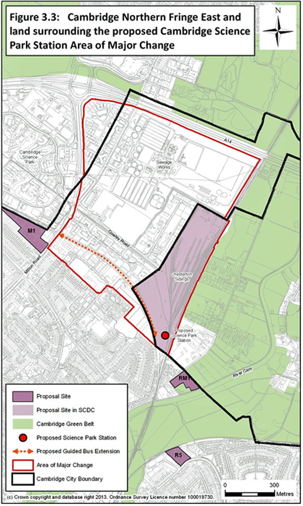
Policy 14: Northern Fringe East and land surrounding the proposed Cambridge Science Park Station Area of Major Change
The Council is seeking the wider regeneration of this part of the city, shown in Figure 3.3, with the creation of a revitalised, employment-focused area centred on a new transport interchange.
The area is allocated for high quality mixed-use development, including employment uses such as B1, B2 and B8, as well as a range of supporting commercial, retail, leisure and residential uses (subject to acceptable environmental conditions).
The quantum of development, site capacity, viability, time scales and phasing of development will be established through the preparation of an area action plan (AAP) for the site. Planning applications will only be considered when the area action plan has been adopted. The AAP will be developed jointly with South Cambridgeshire District Council, and will involve close collaborative working with Cambridgeshire County Council, Anglian Water and other stakeholders in the area. The final boundaries of land that the joint AAP will consider will be determined in the local plans of each authority and by the AAP.
All proposals should:
- take into account existing site conditions and environmental and safety constraints;
- demonstrate that environmental and health impacts (including odour) from the waste water treatment works can be acceptably mitigated for occupants;
- ensure that appropriate access and linkages, including for pedestrians and cyclists, are planned for in a high quality and comprehensive manner;
- recognise the existing local nature reserve at Bramblefields, and where development is proposed provide for appropriate ecological mitigation measures either on- or off-site; and
- ensure that due consideration has been given to safeguarding the appropriate future development of the wider site.
Supporting text:
3.28 Cambridge Northern Fringe East is within the Cambridge City Council and South Cambridgeshire District Council authority boundaries. A coordinated approach to planning of the area across district boundaries will be needed. An early review of the site through a jointly-prepared area action plan will ensure a coordinated approach is taken, and will enable the feasibility of development and its viability to be properly investigated.
3.29 The proposed railway station on the sidings in South Cambridgeshire will be served by the Cambridgeshire Busway and will include cycle and car parking facilities. The station will significantly improve the accessibility of the site and surrounding area, including access to and from Cambridge Business Park, Cambridge Science Park and St John’s Innovation Centre.
3.30 This area forms part of an area of search for a household waste recycling centre to serve the north of Cambridge, and as a location for inert waste recycling. There are also minerals and waste and rail safeguarding areas covering the sidings and other areas of land. Any proposals for these facilities will need to be compatible with other uses in the area.
3.31 The sidings, in South Cambridgeshire, currently have a number of businesses importing aggregate using the railway that is used for construction and road maintenance in the wider Cambridge area. This provides an important source of building materials for the wider area. The operations associated with the ongoing use of these facilities produce noise and dust, and how they will operate in the longer term will be considered in the area action plan.
3.32 Exploration of the viability and feasibility of redevelopment of the waste water treatment works to provide a smaller new treatment works facility on the current site will be undertaken as part of the feasibility investigations in drawing up the AAP. A reduced footprint could release valuable land and enable a wider range of uses. Residential development could be possible, subject to appropriate ground conditions, amenity and air quality.
3.33 The development of Cambridge Northern Fringe East will require partnership working between landowners and developers, as well as the two local authorities and Cambridgeshire County Council.
3.34 The principal land uses, access and transport arrangements are shown in Figure 3.3: Northern Fringe East and land surrounding the planned Cambridge Science Park Station.
Figure 7.1: Policy 14 – Figure 3.3 from Cambridge Local Plan 2014: Proposed Submission
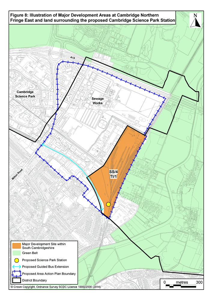
Policy SS/4: Cambridge Northern Fringe East and land surrounding the proposed Cambridge Science Park Station
1. The Cambridge Northern Fringe East and land surrounding the proposed Cambridge Science Park Station will enable the creation of a revitalised, employment focussed area centred on a new transport interchange.
2. The area, shown on the Policies Map, is allocated for high quality mixed-use development, primarily for employment within Use Classes B1, B2 and B8 as well as a range of supporting uses, commercial, retail and residential uses (subject to acceptable environmental conditions).
3. The amount of development, site capacity, viability, time scales and phasing of development will be established through the preparation of an Area Action Plan (AAP) for the site.
4. All proposals should:
- Take into account existing site conditions and environmental and safety constraints in this area;
- Demonstrate that environmental and health impacts (including odour) from the Waste Water Treatment Works can be acceptably mitigated for occupants;
- Ensure that appropriate access and linkages, including for pedestrians and cyclists, are planned for in a high quality and comprehensive manner; and
- Ensure that the development would not compromise opportunities for the future redevelopment of land within the AAP boundary.
Supporting text:
3.28 Cambridge Northern Fringe East is located within the Cambridge City Council and South Cambridgeshire District Council authority boundaries. Chesterton Sidings and most of the land between Cowley Road and Milton Road is in South Cambridgeshire. A coordinated approach to planning of the area across district boundaries will be needed through a Joint Area Action Plan (AAP) which will ensure a comprehensive approach to redevelopment.
3.29 The proposed railway station, on the sidings in South Cambridgeshire, will be served by the Guided Busway and will include cycle parking facilities and car parking. The station will significantly improve the accessibility of the site and surrounding area including access to and from the Cambridge Business Park, Cambridge Science Park and St John’s Innovation Centre making the area a highly attractive business destination.
3.30 This area forms part of an area of search for a household waste recycling centre to serve the north of Cambridge, and as a location for inert waste recycling. There are also minerals and waste and rail safeguarding areas covering the sidings and other areas of land. Any proposals for these facilities will need to be compatible with other uses in the area.
3.31 The sidings, in South Cambridgeshire, currently have a number of businesses importing aggregate using the railway that is used for construction and road maintenance in the wider Cambridge area. This provides an important source of building materials for the wider area. The operations associated with the on-going use of these facilities produce noise and dust and consideration of how these uses will operate in the longer term will be considered in the AAP.
3.32 Exploration of the viability and feasibility of redevelopment of the Waste Water Treatment Works within Cambridge City to provide a new treatment works facility at a smaller scale on the current site will be undertaken as part of the feasibility investigations in drawing up the AAP. A reduced footprint could release valuable land to enable a wider range of uses to be provided through the release of additional land. Residential development could be created subject to appropriate ground conditions, amenity and air quality.
3.33 The development of Cambridge Northern Fringe East will require partnership working between landowners and developers as well as the two local authorities and Cambridgeshire County Council.
Figure 7.2: Policy SS/4 – Figure 8 from Submission South Cambridgeshire Local Plan 2014