Draft North East Cambridge Area Action Plan
7.1 Sustainable connectivity
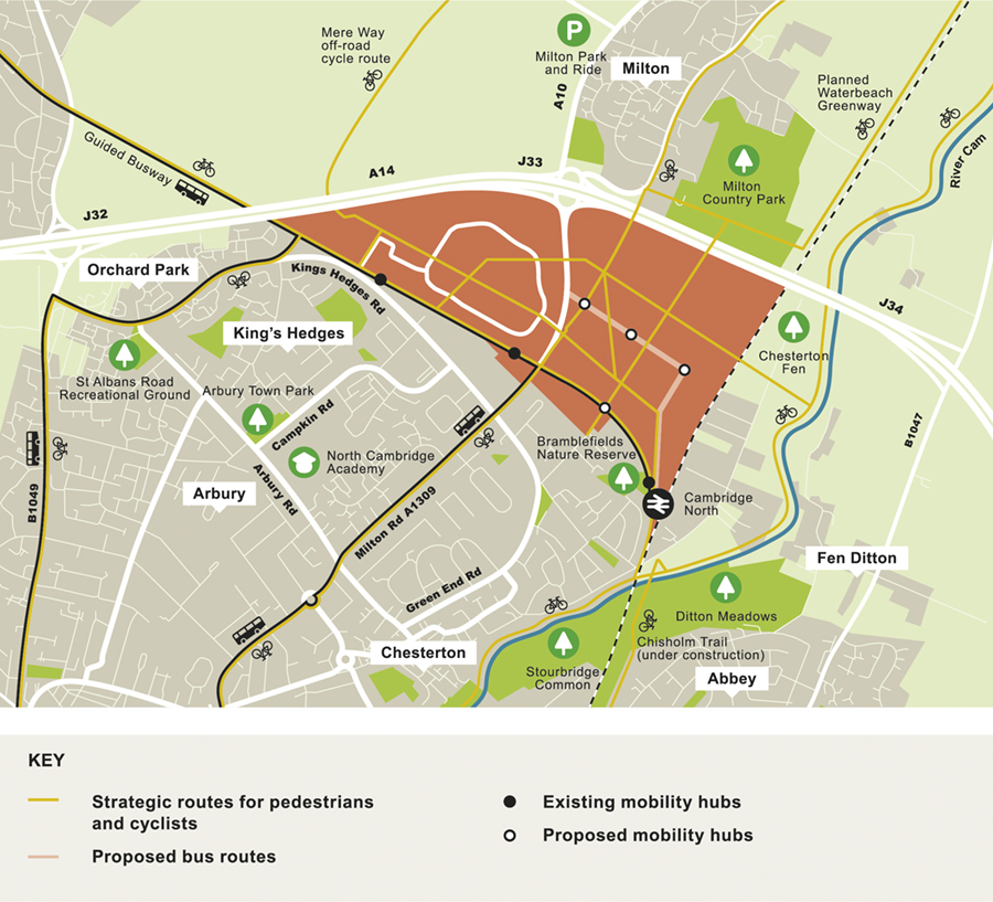
Figure 36: Strategic walking and cycling routes and mobility hubs, to be retained and created in North East Cambridge.
North East Cambridge must be designed around the principles of walkable neighbourhoods and healthy towns, to reduce the need to travel and to encourage sustainable travel choices. The policy sets out how development in the area should create a comprehensive network of routes which are direct, permeable, legible and safe, where people are prioritised over vehicular traffic and can move easily between different forms of sustainable transport in order to complete their journey.
- You supported the inclusion of healthy towns principles, ensuring health and wellbeing through site design and including well designed green spaces and paths for walking, cycling and horse riding for mobility, recreation, exercise, offering visual interest and the opportunity to connect with nature and integrate with public transport. You commented that all walking and cycling infrastructure must design out crime and be fully accessible to people with disabilities and help to redress deprivation in surrounding communities.
- You supported all the options to remove the physical and perceived barriers: improving east-west and north-south connections, including across Milton Road and to the River Cam.
- You commented that cycle congestion exists, that the towpath should be protected from overuse to remain a tranquil area for leisure, and that there are already enough cyclists along this route.
- You supported options for improving public transport, cycling and walking accessibility, including beyond the Area Action Plan boundary. You commented that to get people onto public transport there needs to be more buses at peak times, and it needs to be accessible and better value for money / subsidised. Your suggestions included exploring the appropriateness of another Guided Bus stop, frequent shuttle buses, better use of Milton Park and Ride and Mere Way, develop interchange at Cambridge North station and CAM metro, small electric vehicles, and better local buses connections. You commented that there needs to be high quality information at public transport stops, integrated, cashless ticketing and pay as you go. Buses could also have capacity to accommodate cycles.
- You supported measures that encourage cycling, including employment premises installing secure cycle parking, showers, lockers and drying rooms with easy access. You also commented that pool cycles should be available for businesses in the area as well as bike repair shops and facilities and cargo cycles for last mile deliveries. However there were some concerns that lockers attract crime and have management related issues. It was also highlighted that the Area Action plan should consider charging points for electric cycles and make provision for storage for non-standard cycles which are popular in Cambridge. There is also the need to minimise conflict between different modes such as pedestrians and cyclists.
- You expressed concerns about how the links can be achieved without impacting on existing businesses and their operations and relating to the movement of heavy commercial vehicles (HCVs) around the site, particularly close to schools.
- You made suggestions that Milton Road and King's Hedges Road cannot cope with additional traffic, and that the plan should create places that are people focused rather than car dominated. Your suggestions included a new vehicle connection from the A14 to Cambridge Science Park Fen Ditton, and to plan roads on the periphery of the Area Action Plan site. You commented that the unsafe level crossing at Fen Road should be closed, and alternative provision made, which may include a road bridge into the Area Action Plan area. You commented that the Area Action Plan should not be designed around the need to cater for cars and should do this by reducing the dominance of Milton Road, reconfiguring existing traffic lights and enhancing the public realm. You also noted that car ownership could be discouraged with a dedicated car-pool network and low levels of parking, due to an abundance of other more sustainable transport options. You suggested parking controls should be in place from the construction stage of development and that measures will require landowner support to be effective. You expressed concerns that more consideration is needed to the reality of car use, particularly for those who need cars such as the elderly, disabled or pregnant people, and those with young children, that the Area Action Plan should improve traffic issues rather than worsen them, and redress the imbalance between jobs and housing.
- You commented that the Area Action Plan should embrace technology so that users find it easy to switch between modes and ensure flexibility to future proof and avoid stifling innovation, which may include autonomous vehicles. Your suggestions included cycle hire schemes, on-demand transport for those with low mobility, and micro-mobility solutions. You supported innovative measures such as a centralised consolidation hub to service businesses and retail deliveries, help reduce demand on the highway network and lessen environmental impacts, which could use cycling logistic firms using cargo cycles to make last-mile deliveries. It was also suggested transport is about human centred, safe and convenient space not technology.
How your comments have been taken into account
- Whilst some comments were made that the Area Action Plan needed to consider the reality of car use, it is clear, from the Transport Evidence Base, that for the development to be acceptable in planning terms it will need to mitigate its travel impacts and significantly reduce car usage (car mode share). As a result, the policy approach focuses on reducing the need to travel and facilitating travel by non-car modes rather than catering for vehicular trips. The issue around whether the Fen Road level crossing should be closed and alternative access provided is addressed under Policy 17: Connecting to the wider network.
- North East Cambridge will be designed around the principles of walkable neighbourhoods and healthy towns, to reduce the need to travel and making services and facilities readily accessible and safe for everyone by active modes. Coupled with this, providing an extensive high-quality network of walking and cycling routes within the site and (removing barriers) connecting to the wider area, where the design of the public realm prioritises people over vehicles and provides a choice of on- or off-road route. The policy supports the seamless connectivity and interchange between modes and this will be provided through a series of mobility hubs across the area. A flexible approach has been taken to future proof changes in mobility and technology, in recognition that travel patterns and habits are changing, and that technology is developing all the time. Reflecting the comments received and the placemaking objectives for North East Cambridge, Policy 16: Sustainable Connectivity incorporates all these aspects. The policy provides flexibility and the emphasis is placed on creating the right environment and connections to facilitate mode shift as a personal and/or lifestyle choice.
- Note, a suite of connectivity policies address associated issues in further detail including improving wider connectivity (Policy 17: Connecting to the wider network), Safeguarding for public transport (Policy 19: Safeguarding for Cambridge Autonomous Metro and Public Transport) and Managing vehicular traffic (Policy 22: Managing motorised vehicles).
(11) Policy 16: Sustainable Connectivity
North East Cambridge should be designed around the principles of walkable neighbourhoods and healthy towns to reduce the need to travel and encourage active sustainable travel. This should include a comprehensive network of links and connections that are safe, direct, permeable, legible, integrated with the green and open space network, and where priority is given to people over vehicular traffic with low traffic and design speeds, as well as car free neighbourhoods (see Policies 21 and 7) to encourage active travel trips and deliver excellent connections via high-quality public transport (see Policy 19).
The network should seamlessly integrate and improve connectivity within the site, to the adjoining areas around north Cambridge including nearby villages, Cambridge city centre, employment areas, and utilising green links to the wider countryside and Rights of Way network. Leisure routes should include appropriate provision for equestrians.
The pedestrian and cycle connections to be made as part of North East Cambridge are shown on Figure 36 and include:
- Cowley Road will form a new high-quality spine through the development between Cambridge North Station/Station Approach Local Centre - across Milton Road (via new bridge) - Cambridge Science Park - Cambridge Regional College
- Cambridge Science Park - Milton Road (north) crossing – Cowley Road Neighbourhood Centre - railway crossing – Chesterton Fen open space and River Cam towpath
- Cambridge North Station - District Centre – Cowley Road Neighbourhood Centre – Milton Village (via Jane Coston Bridge)
- Milton Village (via Jane Coston Bridge) – Cowley Road Neighbourhood Centre – Milton Road
- Waterbeach Greenway (under A14) – Linear Park – new Guided Busway stop –– Nuffield Road
- Waterbeach Greenway (under A14) – Linear Park – District Centre – Cambridge North Railway Station/Station Approach Local Centre
- Cambridge North Station/Station Approach Local Centre – Chisholm Trail (proposed) – Cambridge Station – Cambridge Biomedical Campus
- District Centre – Gainsborough Close (East Chesterton)
- Cambridge Science Park – Garry Drive (King's Hedges) -Campkin Road Neighbourhood Centre
- Mere Way (under A14) – Cambridge Regional College – Science Park Local Centre – King's Hedges Road Guided Busway stop (existing)
The public realm must be designed to put people first and to create a vibrant and socially interactive environment (see Policy 7) with a seamless interface with public transport and other travel options at mobility hubs (see Policy 19). The design of streets and spaces should consider the needs of those walking, cycling and using other sustainable modes to minimise conflict between different users, including those using mobility wheelchairs, electric bikes and e-scooters (when legalised).
Innovative and flexible solutions to internalising trips and reducing motor vehicle use are encouraged, including through measures such as:
- digital infrastructure
- online information for journey planning
- Mobility as a Service (MaaS)
- micro-mobility
- demand responsive transport and ride sharing
- smart / mobile ticketing
- cycle taxis
- last mile deliveries (see Policy 20: Last mile deliveries)
- future proofing for technological improvements and the use of autonomous vehicles (see Policy 30)
Relevant Objective: 1, 2, 4, 5
The location and connectivity of North East Cambridge provides a unique opportunity to bring forward a highly sustainable type of development designed around accessibility and the needs of people rather than cars, marking a step change in the way people move around. The strategic objectives for the Area Action Plan state that it must be designed around the principle of walkable neighbourhoods and healthy towns, providing local services, cultural opportunities and amenities that are accessible by everyone, whatever their age and ability, on foot, by cycle and micro mobility modes such as scooters.
Making sustainable travel possible for everyone
Sustainable modes of travel, including walking, cycling and other forms of micro-mobility are zero-emission, socially inclusive, promote health and wellbeing, and help to create a more vibrant and socially interactive environment. To make sustainable travel the first choice for everyone who works, lives and visits North East Cambridge, the new district must be designed from the outset with a network of links and connections that are direct, permeable, legible and safe. This network, together with public transport, will help people access and move around this new city district and wider area without needing to rely on the private car.
To achieve this the city district will be designed around the principles of walkable, low traffic neighbourhoods, removing direct through routes for traffic, discouraging non-essential vehicles into certain areas, and with low traffic speeds (in accordance with Policy 7: Legible streets and spaces and Policy 21: Street hierarchy). Walkable neighbourhoods are designed around prioritising walking and cycling (or use of other sustainable means) to access local services and facilities. These are typically based on distances of 400 metre (5 minute) and 800 metre (10 minute) walking catchments, although this is only a guideline and the key factor is providing attractive, convenient and well designed routes which form part of a coherent network.
A people-first approach will ensure that streets (including junctions) and public spaces will be people-friendly, designed for all ages and abilities with a low-design speed for vehicles, and which are integrated with the built environment. They should also feel safe and be overlooked by buildings which are in use throughout the day and night. Development across North East Cambridge should form a coherent network of streets, paths and green links for people that offers choice for how they move around and through the Area Action Plan area. This includes pedestrians, cyclists and horse riders.
Linking to the wider area
North East Cambridge must be linked to surrounding communities and key employment, social and retail destinations within the wider area, to ensure people do not need to travel by private vehicle. It is therefore essential that North East Cambridge is served by, and seamlessly connected with, existing and planned high quality public transport and routes for non-motorised users.
New and upgraded infrastructure is already being planned and delivered in the vicinity of the site through the Greater Cambridge Partnership, for example the Waterbeach to Cambridge Greenway, Chisholm Trail, and along Milton Road. However, there are currently severance issues and barriers to movement within North East Cambridge (Milton Road) and hindering wider connectivity (A14, railway line, Cambridgeshire Guided Busway and existing development) which will need to be addressed (see Policy 17). It is important that development specific masterplans across the site include networks for existing and planned infrastructure within the site, and must consider whether improvements are needed to the quality or capacity of existing routes in the wider area.
Active sustainable modes also form the 'first and last mile' of longer journeys, connecting people's origins and destinations with high quality public transport. North East Cambridge is already directly served by Cambridge North railway station and bus services, some using the Cambridgeshire Guided Busway. Further high quality public transport services and infrastructure enhancements are proposed within the site and the wider area, including a new route between Cambridge and the proposed New Town at Waterbeach, as well as the Mayor's aspirations for a Cambridge Autonomous Metro (CAM). It is important that seamless interchange through mobility hubs is included in proposals for locations for public transport interchange.
Discouraging car use
The scope for highway capacity improvements is limited due to the existing road configuration and lack of space, particularly at the junction of Milton Road with King's Hedges Road and Green End Road. The already high levels of traffic and peak hour congestion on the existing road network mean that the introduction of additional vehicular traffic is unacceptable in terms of highway capacity, place making and air quality. As a result, development will need to support a significant shift away from the private car and towards sustainable travel to a level not seen in Greater Cambridge previously.
The masterplanning process will ensure the delivery of an environment which puts people first and integrates measures to carefully control vehicular traffic, whilst ensuring essential traffic can be accommodated for those with disabilities who rely on private vehicles or taxis as well as service vehicles. The scale of the required mode shift is such that innovative solutions are going to be needed to reduce not only the need to travel, but also the distances travelled by keeping trips local and putting people first, and, for those longer distance trips that will still need to be made the options are in place from the beginning to encourage and enable modal shift.
The way that people access services and facilities, and personal travel, are evolving, including becoming increasingly digital. There is a shift away from personally owned modes of transport to new models of mobility including more demand responsive travel, 'Mobility as a Service' (a shift away from personally-owned modes of transport towards the integration of various modes of transport along with information and payment functions into a single mobility service. Recent services that allow customers to purchase monthly subscription packages giving them access to public transport and private taxi and bike hire schemes are an example) and micro-mobility (Micro-mobility provides access to on-demand scooters, cycles, electric cycles and potentially other devices that come into the market), with increasing use of on-demand ride-share, scooters and electric scooters, cycles and electric cycles. Technology will have an important role in enabling and supporting this and is constantly evolving; for example, with the implementation of 5G. In the near future, autonomous vehicles may have an important function for first and last mile journeys, demand responsive travel, ride sharing, and deliveries. It is important to future proof infrastructure at North East Cambridge and consider new options and models for mobility within the design of the area.
- North East Cambridge Area Action Plan Transport Assessment (2019) and Addendum (2020)
- Smart Infrastructure Topic Paper: Future Mobility (2020)
- Smart Infrastructure Topic Paper: Environmental Monitoring (2020)
- Internalisation Topic Paper (2020)
- Health Facilities and Wellbeing Topic Paper (2020)
- Anti-poverty and Inequality Topic Paper (2020)
- Manual for Streets (Department for Transport, 2007)
- Waltham Forest Mini Holland Design Guide
- Modal share for pedestrian, cycle, public transport users
- Policy 5: Strategic transport infrastructure
- Policy 15: Cambridge Northern Fringe East and new railway Station Area of Major Change
- Policy 59: Designing landscape and the public realm
- Policy 80: Supporting sustainable access to development
- Policy 81: Mitigating the transport impact of development
South Cambridgeshire Local Plan 2018
- Policy SS/4: Cambridge Northern Fringe East and Cambridge North railway station
- Policy HQ/1: Design Principles
- Policy TI/2: Planning for Sustainable Travel
Cambridgeshire and Peterborough Local Transport Plan – Draft Plan and Policies Annex Cambridgeshire Local Transport Plan 2011-2031 (2015)
Transport Strategy for Cambridge and South Cambridgeshire (2014)
Greater Cambridge Sustainable Design and Construction SPD (2020)
Making Space for People Supplementary Planning Document (Draft 2019)