Draft North East Cambridge Area Action Plan
7.6 Street hierarchy
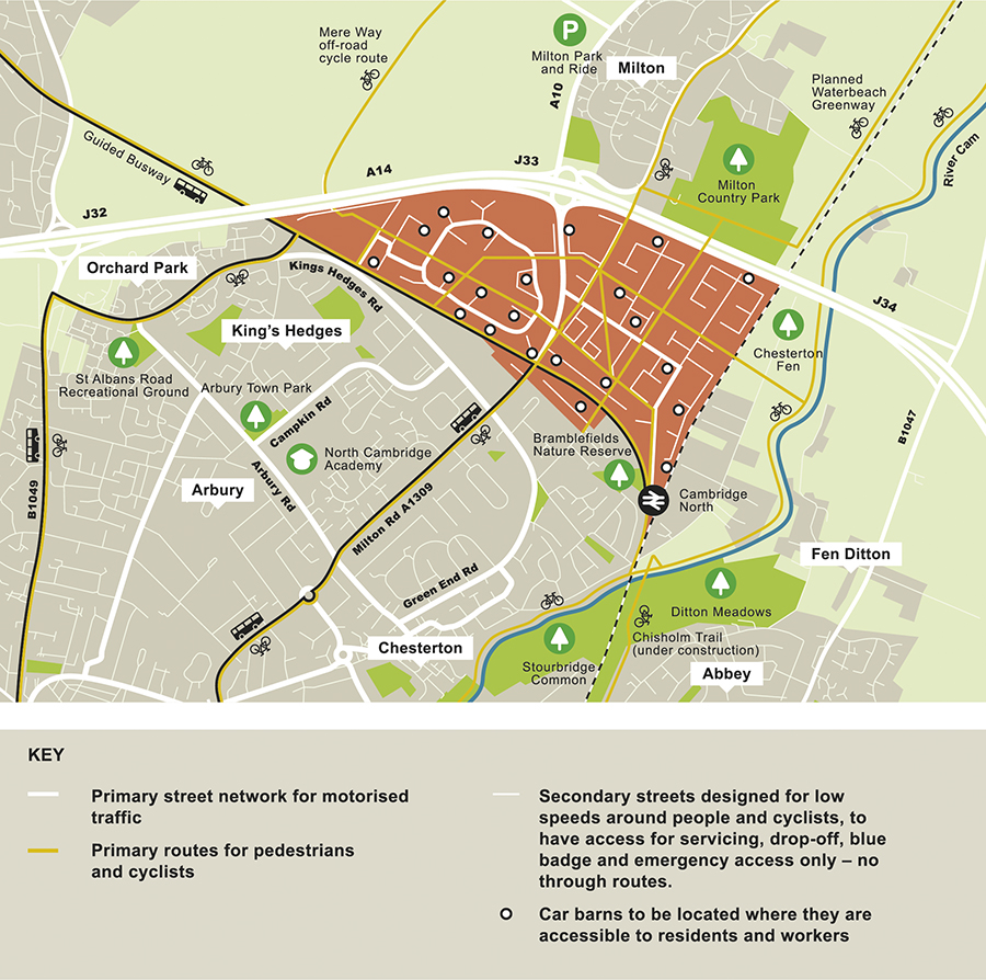
Figure 40: Street hierarchy for North East Cambridge
While North East Cambridge will be designed around active travel as the first choice, we must also ensure that there is a functional street network for vehicular access, for emergency vehicles, servicing local businesses, and for people with mobility issues as well as community transport and taxis. This policy describes the primary and secondary street network, and how these streets should be designed to lower vehicle speeds, and with excellent provision for walking and cycling to ensure these remain the travel mode of choice. It also sets out how space efficient car parking should be provided in 'car barns' so that residents and workers who need to occasionally use cars, can access private or shared cars.
- You supported facilitating non-car travel modes, including provision of an extensive network of routes for active travel, high quality public transport, but without cutting off access for those who need cars.
- One comment suggested that main roads should be kept to the periphery of the development.
- You commented that industries requiring lots of large lorries are considered incompatible with safe cycling and walking.
- You commented that provision for non-car modes is necessary to implement a trip budget approach and reduce car dependence; this would also support low levels of car parking and provision of a car pool hire scheme could help to reduce car ownership. You felt that a robust and well-funded area-wide Travel Plan is needed.
- You said we should consider the reality of car use, and provision should be made for car journeys into Fen Road
- You suggested centralised refuse collection and a consolidation hub for deliveries to help reduce demand on the highway.
How your comments have been taken into account
- It is not a feasible option to ban vehicular traffic from North East Cambridge completely. Access is needed for emergency vehicles and to meet servicing requirements of local businesses, retail and community uses, and by people with mobility issues. Vehicles such as public transport, community transport and taxis provide an important part of the wider mobility model. However, a site-wide network of through routes for vehicles would undermine efforts to reduce car use and encourage active travel. The proposed policy therefore manages vehicular traffic onto the most appropriate streets to enable the new city district to function appropriately. This is broadly in line with your comments that vehicle use should not be banned but should be reduced as far as possible.
- New vehicular links to areas outside North East Cambridge, such as across the railway to connect with Fen Road, could encourage a greater level of traffic through North East Cambridge and undermine the aspirations to reduce car use. Any move to close the level crossing will need to be initiated by Network Rail and go through due processes. The authorities will need to work together to form a view on where any alternative should go to deliver the best outcomes, should this situation arise.
- In response to your comments, delivery consolidation is dealt with in Policy 20: Last mile deliveries.
(6) Policy 21: Street hierarchy
North East Cambridge should be designed to manage vehicle movements in accordance with the street hierarchy shown in Figure 40 and the design principles described in Policy 7: Legible streets and spaces and shown in Figure 16, Figure 17 and Figure 18:
-
Primary streets will provide the main vehicular access into and within North East Cambridge. They should be designed to:
- Include high quality segregated paths and cycle paths for all non-vehicular users, including micro mobility.
- Give priority to active sustainable modes across junctions using the primary street and across side roads.
-
Secondary streets will provide access to the wider area for essential emergency vehicles, as well as servicing commercial, community and residential properties, off-plot car parking in car barns (including car pool hire schemes), and to provide access for people with mobility issues. These should be designed to
- Provide full permeability and priority for active sustainable modes.
- No through routes for non-essential traffic, with filtered permeability to enable access for essential vehicles.
- Public realm designed for low traffic volumes and speeds below 20 mph.
- Any loading bays, drop-off/pick-up points and vehicle parking for people with mobility issues, should be integrated into the public realm. Innovative solutions should be considered to 'manage the kerb'.
Consideration should be given to the incorporation of car-free zones, particularly close to centres of activity and mobility hubs.
Relevant Objectives: 1, 4, 5
It is not intended to prevent vehicular traffic within North East Cambridge but to minimise and manage vehicle movements through a clear street hierarchy and filtered permeability. Filtered permeability "filters out" through car traffic on selected streets to create a more attractive environment for walking and cycling, while maintaining accessibility for emergency and service vehicles. This will maintain appropriate access to all areas to enable the area to function in a manner that will not undermine place making and active travel objectives. All streets will be designed around people, with low traffic speeds, and according with the design principles outlined in Policy 7: Legible streets and spaces and shown in Figure 17, Figure 18 and Figure 19:
Primary streets
The main vehicular access to North East Cambridge will be via primary streets which will serve the key areas including Cambridge Science Park and Cambridge North railway station. They have been designed to keep traffic away from centres where there will be clusters of public uses and activity, such as the district and neighbourhood centres, schools and other spaces where the public realm puts people first, to minimise conflict.
Whilst primary streets will be the main traffic routes through the site, priority will be maintained for active travel routes at all junctions to provide seamless connections and maintain continuity for cyclists and pedestrians, adopting 'Mini-Holland' principles. Crossing points should be level, safe (with good sight lines and lighting), and ensure traffic is required to give way.
High quality segregated routes and spaces for pedestrians and cyclists will be provided to maintain separation and minimise conflict between different users travelling at different speeds, as well as from vehicular traffic.
Secondary streets
Secondary streets will be accessed from the primary streets and provide access to the wider area for essential emergency vehicles, as well as servicing commercial, community and residential properties, off-plot car parking, and to provide access for people with mobility issues. These streets will be designed as no-through routes (except for essential traffic such as emergency vehicles) to reduce circulating traffic and create opportunities for car free zones within the development. With low traffic volumes the design of secondary streets should be more inclusive for all users within a shared space with less need for physical segregation, although there should be clear delineation for different users (for example through use of different surfacing materials and low kerb heights) to minimise conflict, particularly for vulnerable users such as those with visual impairments.
Consideration should be given to any vehicle parking, including for people with mobility issues, space for drop-off / pick-up and delivery vehicles (allowing flexibility for future technological advances such as autonomous vehicles), and to integrate it into the public realm in a way that the space can be repurposed when the space is not in use.
- North East Cambridge Transport Assessment (2019) and Addendum (2020)
- Ely to Cambridge Transport Study (2018)
- Smart Infrastructure Topic Paper: Future Mobility (2020)
- Smart Infrastructure Topic Paper: Environmental Monitoring (2020)
- Internalisation Topic Paper (2020)
- Skills, Training and Local Employment Opportunities Topic Paper (2020)
- Waltham Forrest Mini Holland Design Guide (2015)
- Manual for Streets (2007)
- Number of vehicles using primary and secondary streets
- Number of cars parking in undesignated places
- Policy 59: Designing landscape and the public realm
- Policy 80: Supporting sustainable access to development
- Policy 81: Mitigating the transport impact of development
South Cambridgeshire Local Plan 2018
- Policy HQ/1: Design Principles
- Policy TI/2: Planning for Sustainable Travel
Cambridgeshire and Peterborough Local Transport Plan – Draft Plan and Policies Annex
Cambridgeshire Local Transport Plan 2011-2031 (2015)
Transport Strategy for Cambridge and South Cambridgeshire (2014)
Greater Cambridge Sustainable Design and Construction SPD (2020)
Making Space for People Supplementary Planning Document (Draft 2019)