Grafton Area of Major Change SPD 2017
2 SITE AND CONTEXT
2.1 SITE LOCATION
2.1.1 The Grafton Area is located in the eastern part of Cambridge city centre, to the south of Newmarket Road and to the west of East Road. It is a 10 minute walk from the other part of the primary retail area in the city centre and the historic core across Christ's Pieces. The area is bordered to the west by New Square and includes the retail units along the north and south sides of both Fitzroy Street and Burleigh Street. The SPD area includes all of the Grafton Centre, its car parks and service areas.
2.1.2 Figure 5 illustrates a selection of views of the area as it currently exists.
Figure 5 Existing site photographs. Top: Looking east along Fitzroy Street.
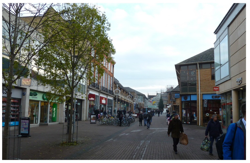
Figure 5 Existing site photographs. Middle: Looking along Burleigh Street from East Road.
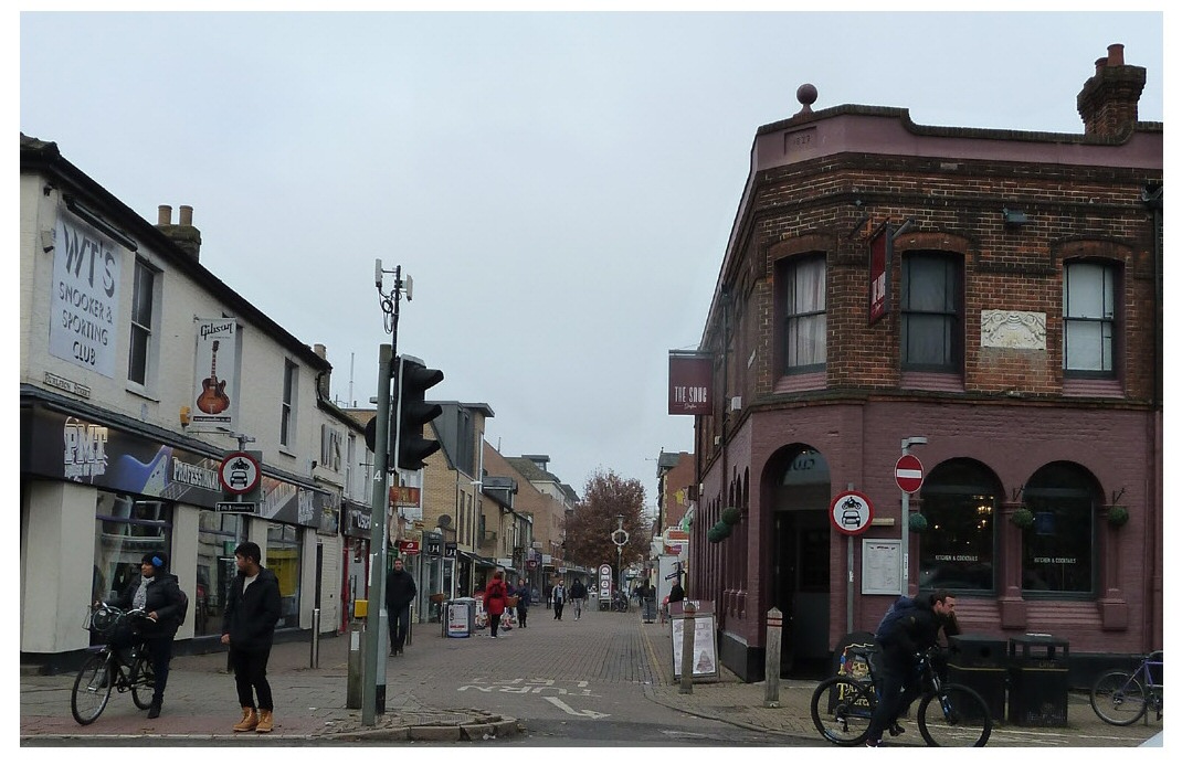
Figure 5 Existing site photographs. Bottom: The Grafton Centre from East Road

Land ownership
2.1.3 The majority of the
site is owned by Legal & General Property. This is managed by
the developer Wrenbridge, who are managing the refurbishment
of The Grafton on behalf of the landowner. The areas of
highway within the SPD area are under the control of
Cambridgeshire County Council. The rest of the land ownership
within the area, particularly along Burleigh Street and the
south side of Fitzroy Street is fragmented across multiple
landownerships.
2.2 MOVEMENT AND ACCESS
Streets
2.2.1 Key movement information is identified on Figure 6.
(1) Figure 6 Vehicle access
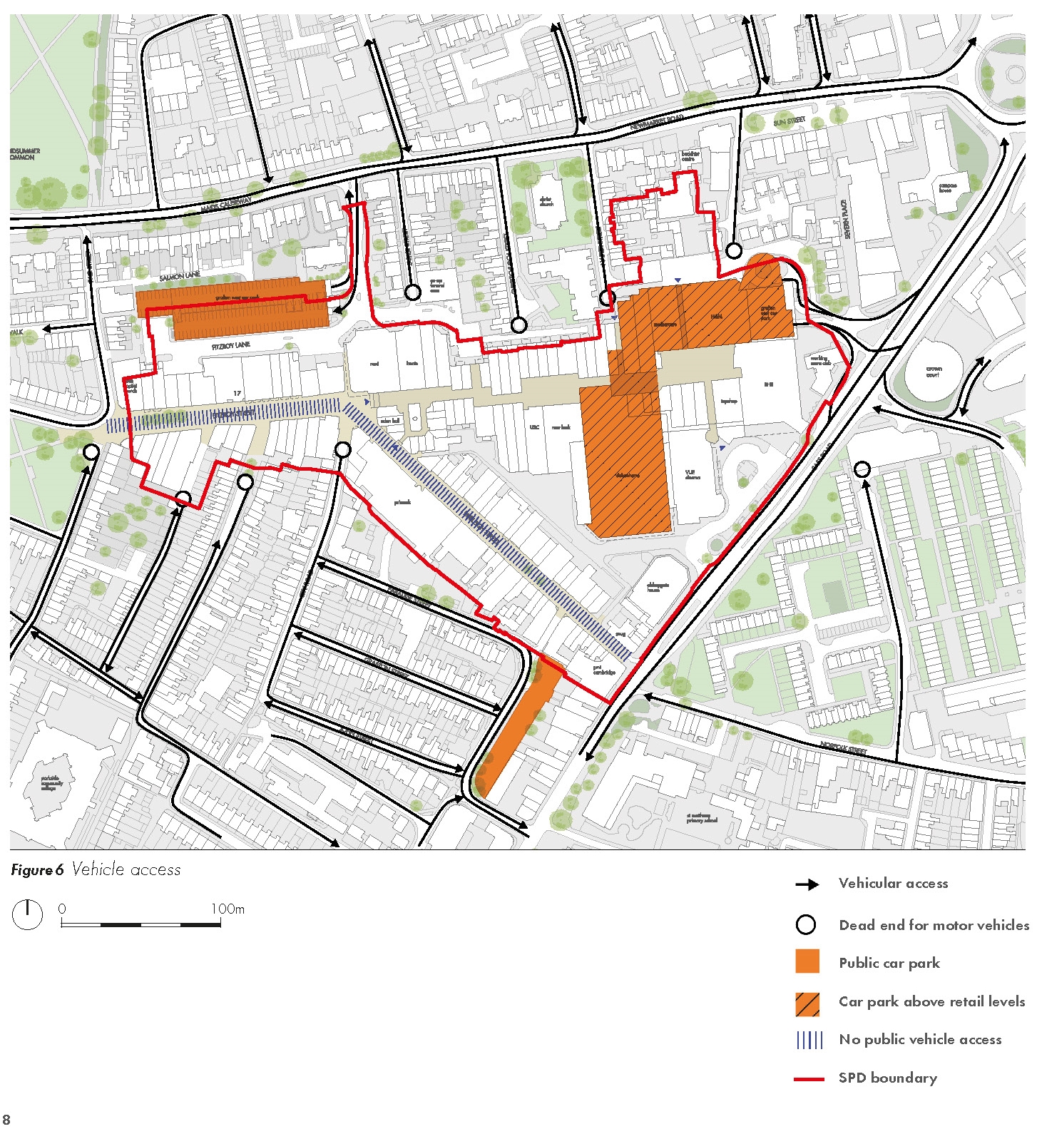
(1) 2.2.2 The Grafton Area is bounded to the north by Newmarket Road and to the east by East Road which form the major routes through the area. These roads converge at a large roundabout to the north east of the study area. All other vehicular routes are more minor residential streets, many of which are dead-ends apart from for cyclists and pedestrians which have been severed by the Grafton Centre or the partial pedestrianisation of Fitzroy Street and Burleigh Street.
Parking
(1) 2.2.3 There are three public car parks within the area, two are associated with the Grafton Centre, the largest of which is the Grafton East MSCP on the roof of the centre accessed from East Road (876 spaces). Grafton West Car Park has two decks of car parking and is accessed from Maids Causeway/Newmarket Road (284 spaces). The third car park is the smaller Adam and Eve Street car park which is located just to the south of the SPD boundary (40 spaces).
(1) 2.2.4 The site is within a Controlled Parking Zone (CPZ) which means on street parking is restricted at certain times of day.
Public transport
(2) 2.2.5 Figure 7 illustrates the current arrangements for cycle access and public transport.
(4) Figure 7 Cycle access and public transport
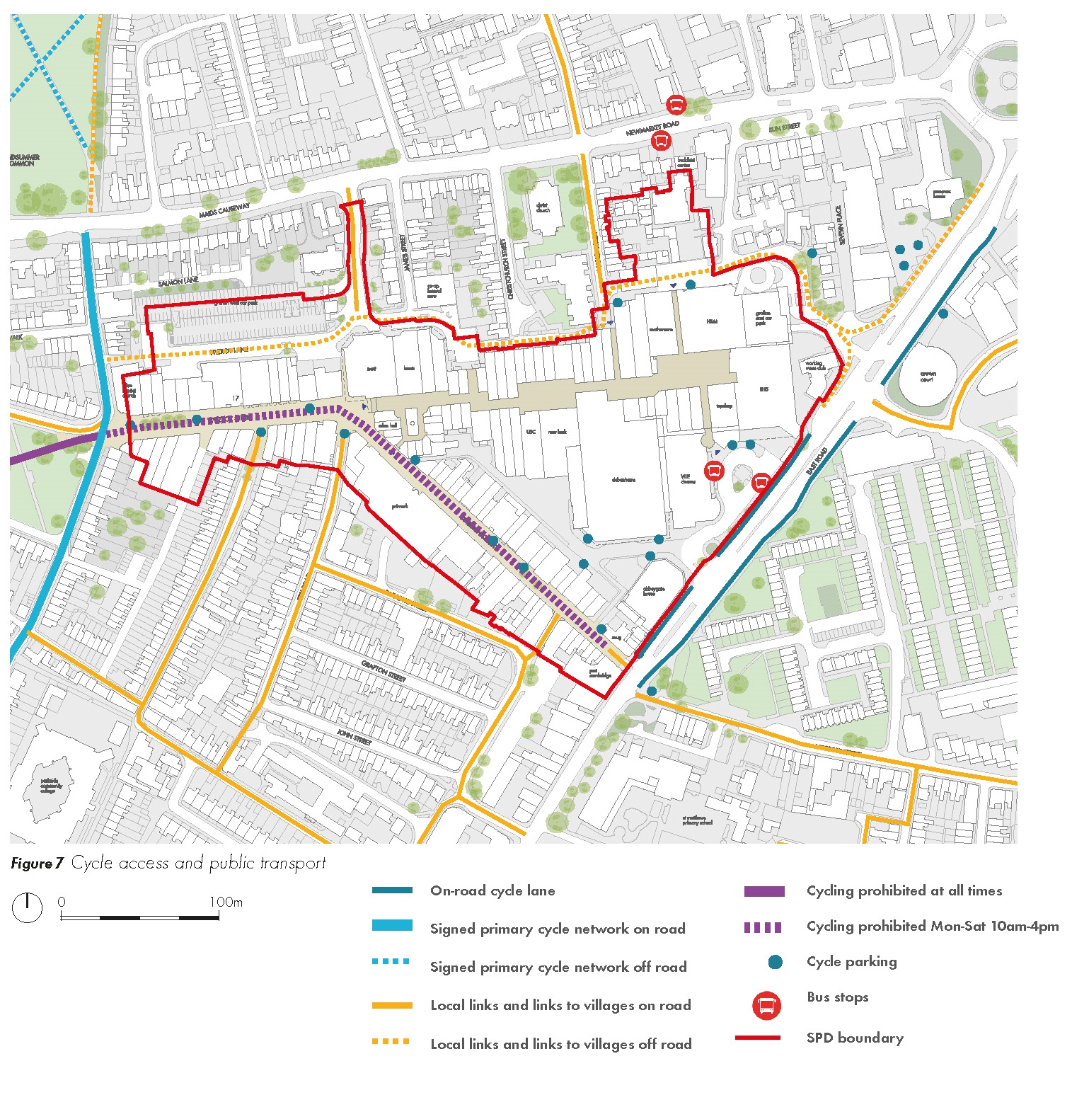
2.2.6 Bus links are excellent from the area with bus stops provided on East Road and Newmarket Road, as follows:
• Newmarket Road/Milton Road Park and Ride buses serve the East Road/Grafton Centre bus interchange
• Madingley Road Park and Ride buses stop on Jesus Lane/Emmanuel Street
(1) 2.2.7 All Park and Ride services provide a frequent 10-minute service throughout the day. On Newmarket Road the services are both inbound and outbound and on Milton Road the services are outbound only. Cambridge Railway Station is a 15-20 minute walk in a south easterly direction from the site.
(2) 2.2.8 The bus "pull-in" area on East Road is not an efficient use of space and adds to the journey times of many bus routes serving the area. The Park and Ride services currently divert from their line of route along East Road to serve the Interchange, with a subsequent increase in journey times when compared with serving an on-street stop. The large areas of tarmac and undefined areas of public realm have a negative impact on the environment.
Cycle routes and parking
(10) 2.2.9 East Road has cycle lanes along its length in both directions and Newmarket Road has a section of cycle lane west of its junction with James Street. Cycling is not permitted along Burleigh Street and Fitzroy Street between 10am-4pm Monday to Saturday, however on-site observations confirm that Burleigh-Fitzroy Street is regularly used as a cycle route during these hours. Fitzroy Street currently experiences two-way flows of over 2,300 cycles between 7am and 7pm on a typical day. These routes will need to be incorporated and improved in any plans for the area.
(7) 2.2.10 Cycle parking is accommodated within the public realm on Burleigh Street and Fitzroy Street, and on East Road near the junction with Burleigh Street, within the Bus Interchange area and at numerous other locations around the Grafton Centre. An audit of existing cycle parking provision has confirmed that a total of approximately 550 cycle parking spaces are currently provided. The location and amount of cycle parking will need to be carefully reviewed as part of this SPD, with the existing cycle parking provision to be considered as a minimum.
Site access
2.2.11 Figure 8 summarises current patterns of access and servicing to the site for motor vehicles.
(1) Figure 8 Service access
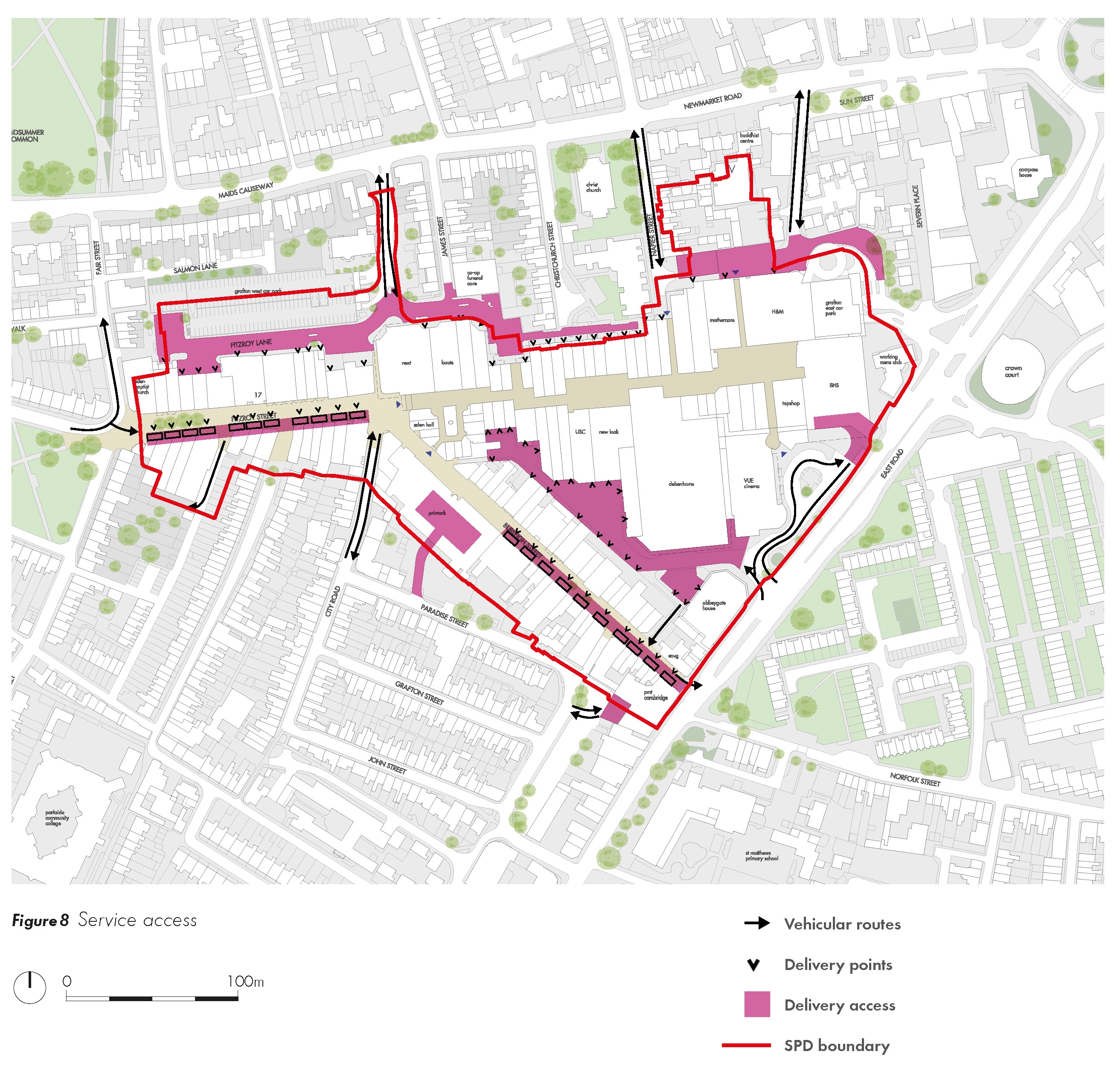
(1) 2.2.12 East Road and Newmarket Road provide the main vehicular access routes to the area, with the entrance to the Grafton Centre main car park (Grafton East MSCP) from East Road.
2.2.13 There are currently no vehicular access routes directly through the site. However limited vehicular access is permitted at the southern end of Burleigh Street and the western end of Fitzroy Street as they are generally pedestrianised. Access to the southern end of Burleigh Street is from East Road via Dover Street and Adam and Eve Street, with egress directly onto East Road (left-turn only). The remainder of Burleigh Street is pedestrianised with no vehicular access except for loading. Fitzroy Street is pedestrianised with no vehicular access, except for loading.
2.2.14 East Road is a very busy vehicular route which currently experiences two-way 12hr vehicle flows between 7am and 7pm of circa 20,400 vehicles on a weekday and 18,500 vehicles on a Saturday (source Full Manual Classified Traffic Count, May 2017). The Greater Cambridge Partnership are currently revisiting the City Access 'eight-point plan', therefore the function of East Road needs to be informed by the outcomes of the City Access Study and considered holistically with consideration of the conflicting demands placed on this corridor. Opportunities exist to improve the environment along East Road and there is some flexibility around the future function of this corridor.
(2) 2.2.15 The centre is serviced both from East Road and points along Newmarket Road, with the service yards highlighted in pink on Figure 8. The retail units on Burleigh Street and the south side of Fitzroy Street are serviced on street, outside of main shopping hours. A detailed review of the existing servicing of the retail units within the Grafton Area has been undertaken as part of the background to the SPD. It is likely the existing full extent of service areas is no longer required by the centre. The potential conversion of redundant servicing areas to provide active uses, redevelopment opportunities and public realm improvements will be reviewed and will be informed by a detailed study of existing servicing areas and engagement with County Highways/Transport teams.
(2) 2.2.16 The surrounding residential streets are accessed via East Road and Newmarket Road and are often one way due to the dead-ends created by the Grafton Centre and the pedestrianisation of Burleigh Street and Fitzroy Street
2.3 LAND USE
Existing land uses
2.3.1 Figure 9 illustrates the current pattern of ground floor land uses in the SPD area. The majority of the SPD area currently contains the Grafton Centre and associated areas of servicing and car parking. This shopping centre contains a range of national multiples, large format stores including a Debenhams department store and leisure uses including a Vue cinema. Fitzroy Street and Burleigh Street run along the southern edge of the area and are dominated by retail, service and cafe uses at ground floor. On upper floors there are some residential and employment uses. Along East Road and to the north of the Grafton Centre there are a number of smaller office blocks and buildings containing community uses.
Figure 9 Existing ground floor land uses
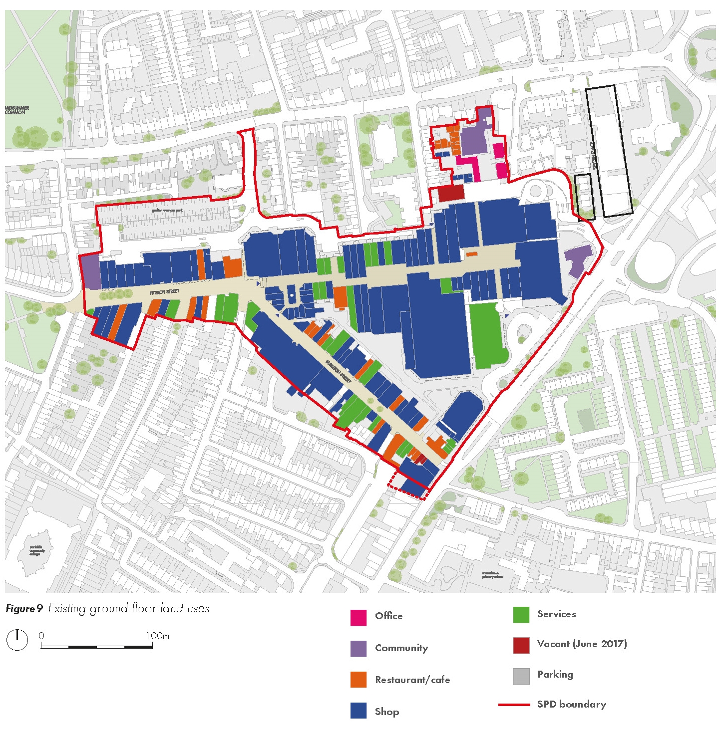
(2) 2.3.2 The area immediately surrounding the SPD area is generally a low rise residential neighbourhood which currently contrasts with the scale of the Grafton Centre.
The changing face of the retail environment
(1) 2.3.3 Today 75% of the population shop online and more than a quarter do so at least once a week, with Britons spending £91 billion a year on the internet. Online supermarket shopping is more significant in the UK than any other country (5% in 2014). The share of retail trade completed online has grown significantly to 16.8% in 2016 (Centre for Retail Research 2016), and is predicted to continue rising albeit more slowly over the next decade to 20 or 25%.
2.3.4 Online retail still needs a physical presence, and less than half of online retail sales are with online-only businesses. Retailers are focusing on the integration of 'multichannel' opportunities, with smaller stores with limited ranges in smaller town centres which act as 'showroom' and contact point for Click and Collect orders. It is also driving co-location of stores, with for example Argos now locating within Sainsbury's stores and also accepting eBay parcel collections. These changing retail trends have had an impact on the form and amount of comparison retail space delivered in town centres, generally reducing the amount required within new developments.
(1) 2.3.5 Large convenience store development has reduced/ceased but the smaller format stores (e.g. Tesco Metro) is one of the fastest growing sectors. The introduction of Lidl/ Aldi has also seen growth in a different form.
2.3.6 Town centres are also becoming increasingly important locations for leisure, hospitality and evening economy uses, shifting the mix of uses that are occurring within high streets. Nationally footfall was up in March 2017 compared to 2016, and Cambridge High Street Footfall was up by 10,5% within this period (Cambridge BID 2017). Much of this footfall increase was identified in the post 5pm period which provides evidence for the importance of a strong leisure offer as a footfall driver.
2.3.7 Many of the major trends affecting the High Street over the last decade have ultimately resulted in a shift in approach rather than the more significant downturn envisaged. The factors affecting town centres are multiple and varied. Some factors have direct impacts on the viability of nonresidential uses, other factors have more of an indirect but powerful influence.
2.3.8 Demographics – the catchment population will have a big impact on the type of retailand leisure uses.
2.3.9 Changing markets – changing demands within different retail streams and employment activities can have a quick and direct impact on high streets.
2.3.10 New technology – the impact of technology on retail has been profound and is still evolving. The impact on other nonresidential uses such as the restaurant industry is, and will be, just as significant whilst perhaps physically more subtle.
2.3.11 Lifestyles / consumer expectations – rapidly changing lifestyles and expectations are in part linked to new technologies in how they influence town centres. Opening hours and the mix of uses in centres are also increasingly influenced by consumer lifestyles.
2.3.12 Working/business practices – the emergence of working at home, shared workspace and live-work units are evidence of the changing nature of the working economy.
2.3.13 Future sustainability – building in the capacity for more sustainable operations to enable lifestyle/ market shifts is essential.
2.3.14 Rising costs of major resources – cost of wheat, oil, water and energy is expected to rise as supplies fail to keep pace with demand, this will impact all town centre uses from the cost of food (and therefore the extent of food outlets) through to the viability of large employment space.
2.3.15 Climate change impacts and adaptations - from disruptions to the supply chain through to physical impact on the comfort of the high street for outdoor dining and dwell time. Adaptations can help to mitigate these impacts.
2.3.16 By far the most important implication of all these factors is the need for flexibility in high streets and town centres. The typologies employed need to build in longevity and enable different uses to occupy spaces over time. Key factors include how blocks are structured to support servicing and access that do not cause conflicts, and the grain and depth of blocks to enable smaller and larger operations to be more interchangeable.
Retail need
(1) 2.3.17 The identification of the AOMC as an opportunity for increased floorspace was derived from the Plan's Evidence Base, principally: the Cambridge City Centre Capacity Study (Arup, May 2013) and the Cambridge Retail and Leisure Study Update (May 2013). The Capacity Study found that there is a long term opportunity for the redevelopment of the Grafton Centre. This includes mixed use (residential above retail) and retail. An initial assessment identified a redevelopment could achieve an uplift of 12,000 sq.m Gross Internal Area (GIA). This would need to be the subject of masterplanning, as now referred to in the emerging Policy 11.
Frontage
(1) 2.3.18 Figure 10 illustrates active and inactive frontages in the AOMC. The impact of the Grafton Centre on the surrounding area and the extent to which it presents an inactive frontage to surrounding streets can clearly be seen. A typical town centre block should have an active front with doors and windows facing the street, with the rear of buildings contained within the perimeter block, shielded from view by the adjacent street. The shopping centre contains its activity within the building and presents blank frontages, service yards and car parking to the street which has a negative impact on the legibility of the area and quality of the public realm.
Figure 10 Existing frontage analysis
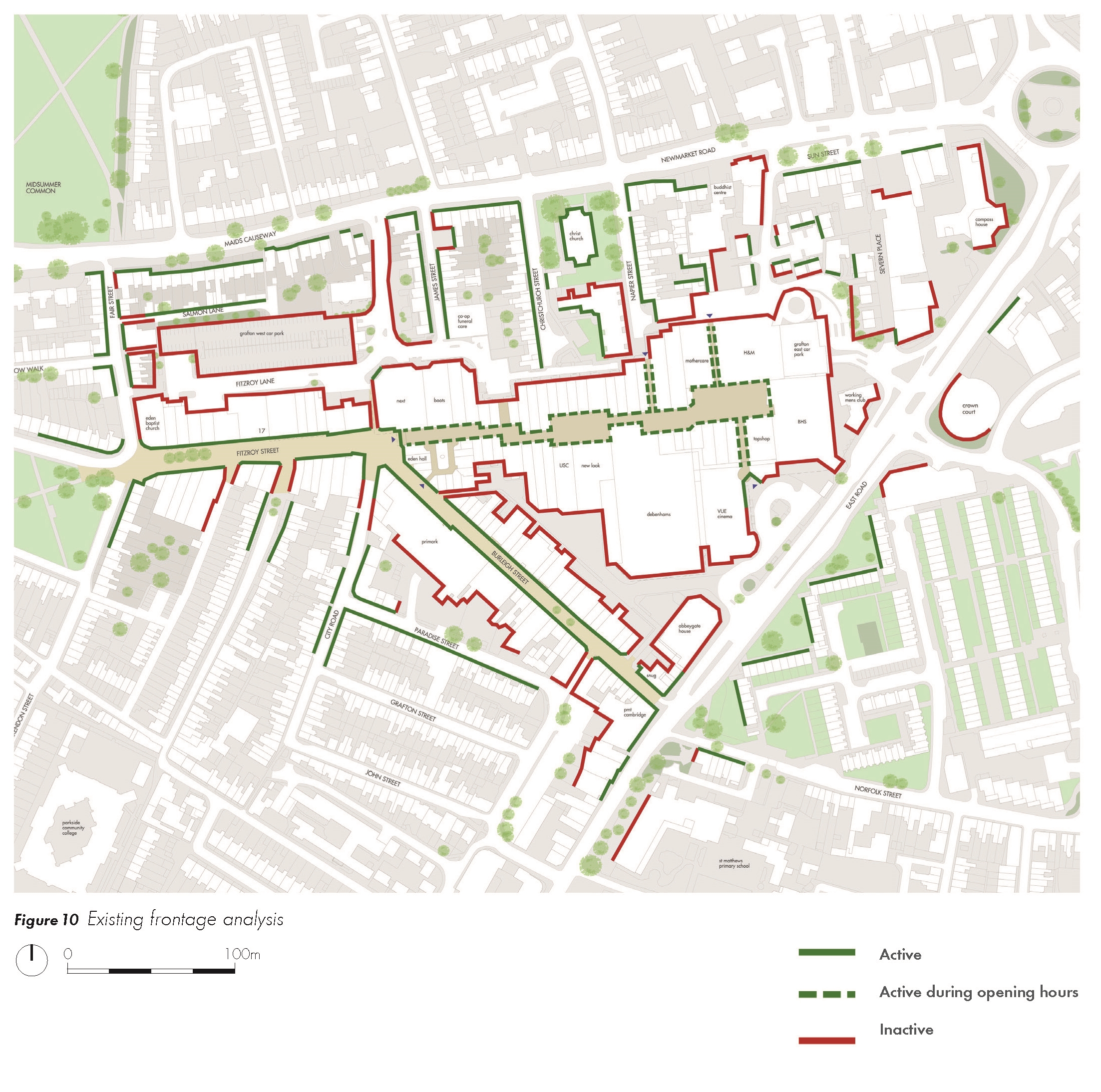
2.3.19 The Grafton Centre has also caused a confused street pattern with many dead ends leading to the centre causing a break down in the natural pattern of fronts and backs of buildings. Where streets meet the centre, buildings face multiple directions, which has a negative impact on the legibility of the area.
(1) 2.3.20 East Road is one area that has particularly suffered in terms of the gap in activity along the length of the Grafton Centre that faces this street. Other buildings along this street do not have a positive relationship with the street with areas of blank frontages and mirrored glazing.
2.4 SCALE, MASSING AND BUILT FORM
Existing building heights
(1) 2.4.1 Building heights vary across the site and the bulk and massing of the Grafton Centre is significantly larger than any other building in the surrounding area. Generally the centre is the equivalent of three residential storeys in height. The tallest buildings in the area are around four storeys including the Cambridge Crown Court and a number of the office buildings along East Road and Newmarket Road. The portion of East Road within and immediately surrounding the study area generally has a taller and bulkier building grain than the rest of the SPD area.
2.4.2 When constructed the Severn Place scheme (Alison Brooks Architects) between Newmarket Road and East Road will add to the taller buildings visible along East Road rising to eight storeys when implemented (see Figure 38 for context). The scheme has a lower scale along the Newmarket Road frontage.
(1) 2.4.3 Burleigh Street and Fitzroy Street are generally two and three storeys with the Primark building rising to four storeys. The listed number 17 Fitzroy Street also rises to four storeys.
2.4.4 The area surrounding the site is mainly comprised of residential two-storey housing, although there are a number of three-storey houses on Newmarket Road. Behind these properties Salmon Lane has a very intimate scale with a mix of single and two storey coach houses. Existing building heights are shown in Figure 11.
Figure 11 Existing building heights
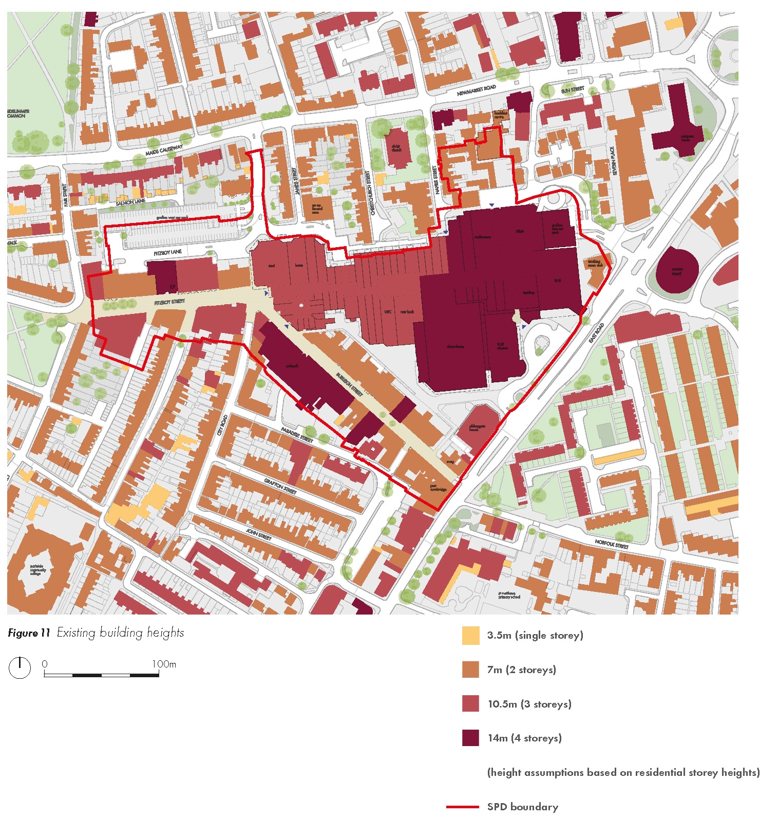
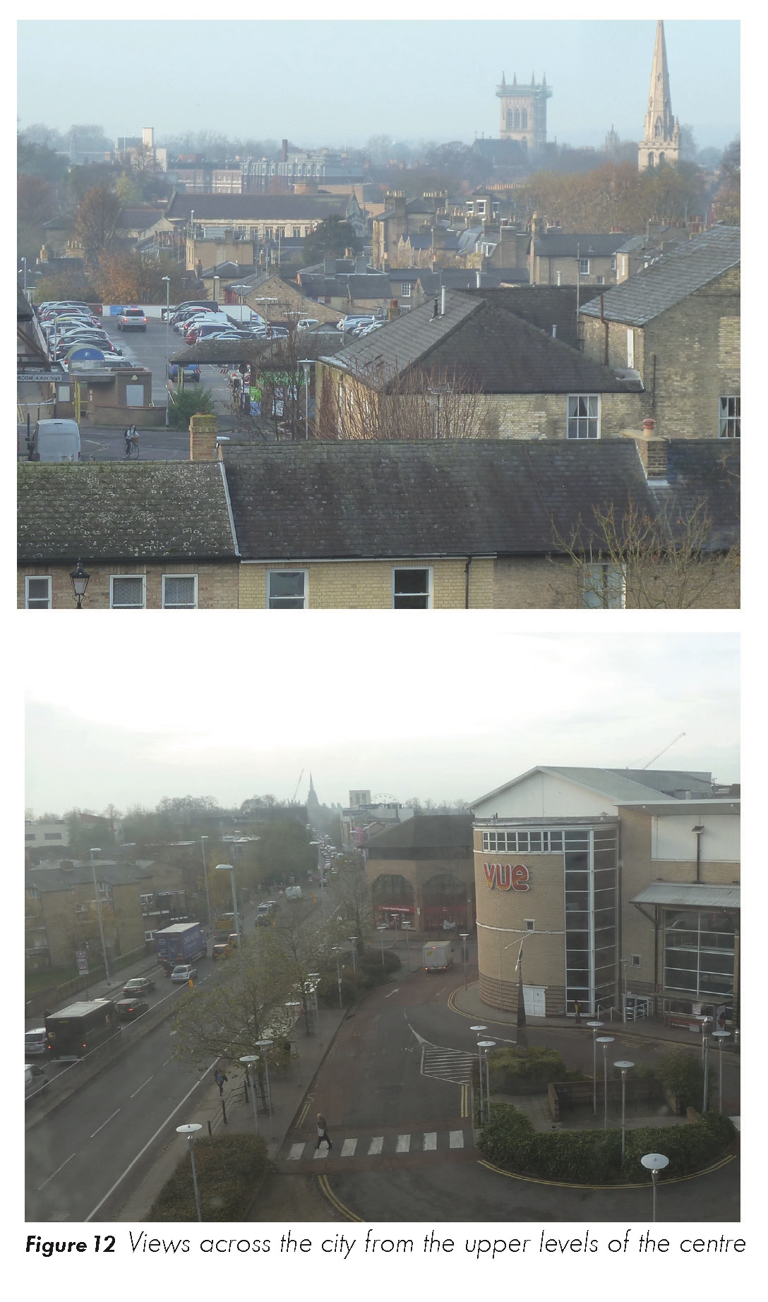
Figure 12 Views across the city from the upper levels of the centre
Historic development
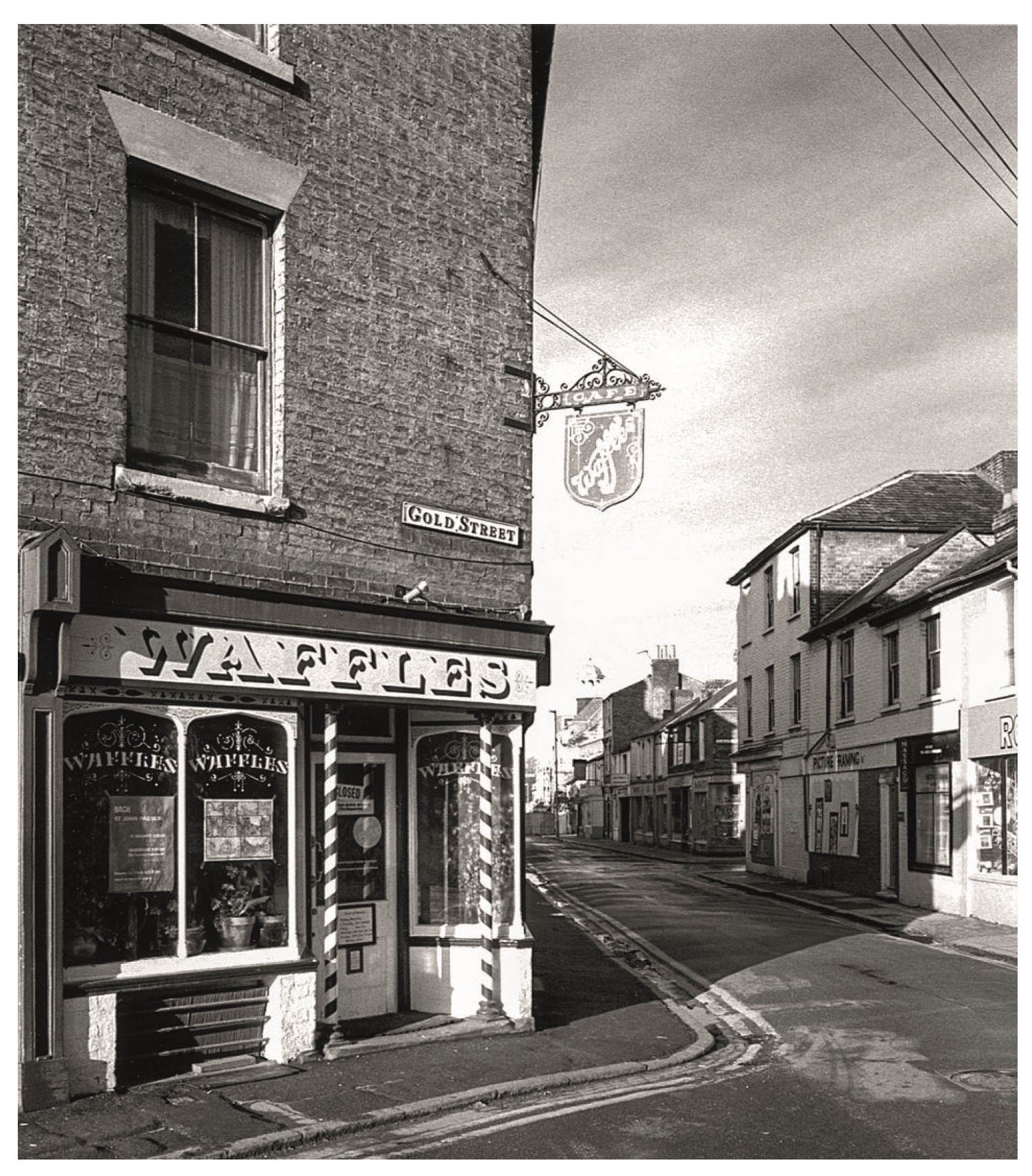
2.4.5 The historic maps (Figure 13) illustrate how dramatically the area has changed over the last 150 years. The orange structure of routes on the 1880s plan highlights the key routes that existed within the study area, including the continuous east/west route along Fitzroy Street, running through to East Road. Gold Street also used to connect between Fitzroy Street to East Road. Gold Street is shown in the bottom photo of Figure 14.
Figure 13a Historic development - 1888
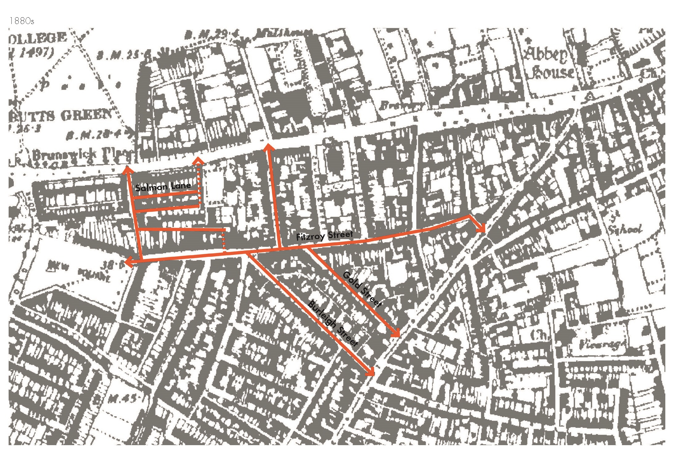
Figure 13b Historic development - 1983
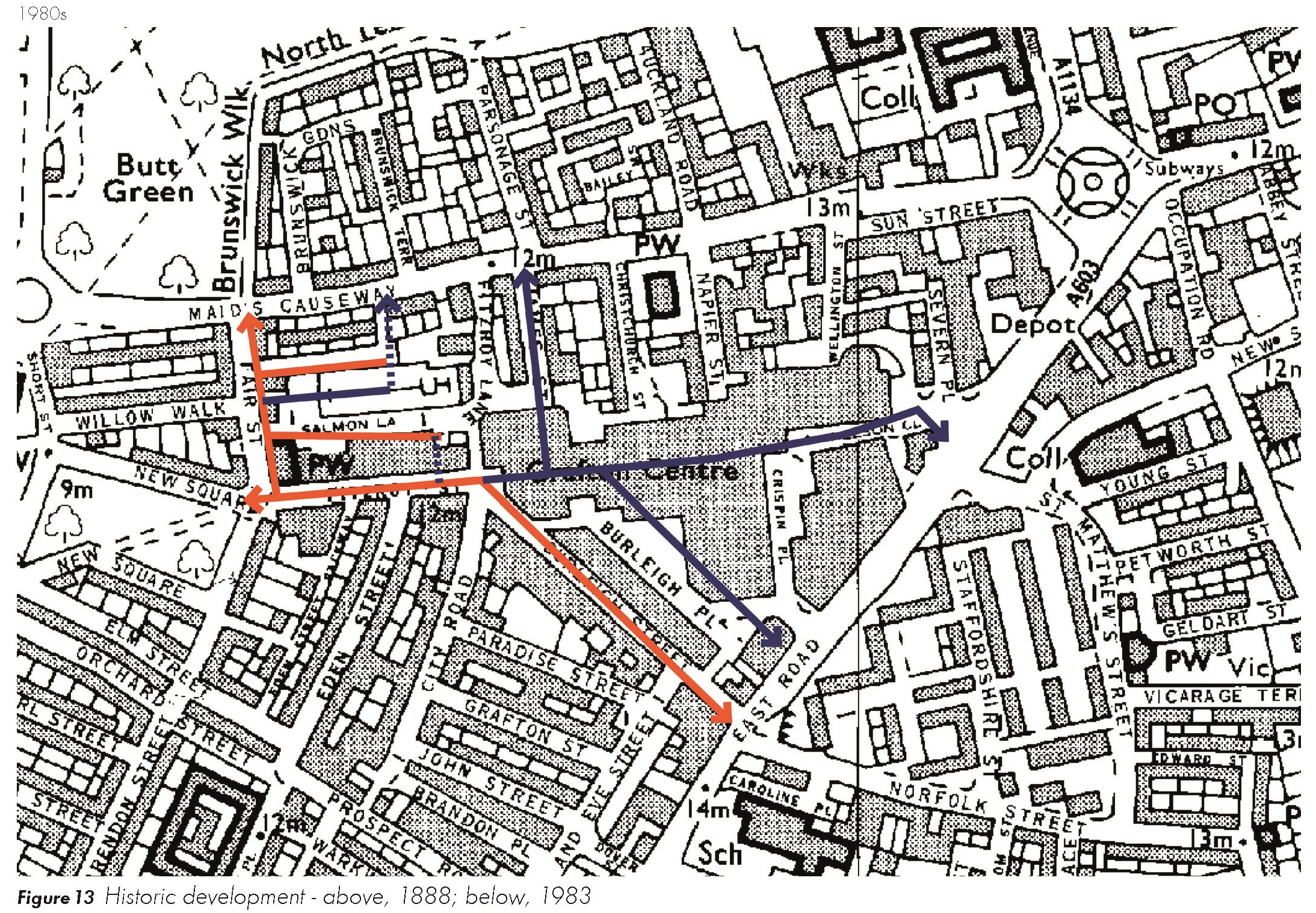
Figure 14 The Grafton Area before the shopping centre was built. Top: The Old Co-op on Burleigh Street.

(1) Figure 14 The Grafton Area before the shopping centre was built. Middle: Eden Chapel which is retained on the edge of the Grafton Centre.
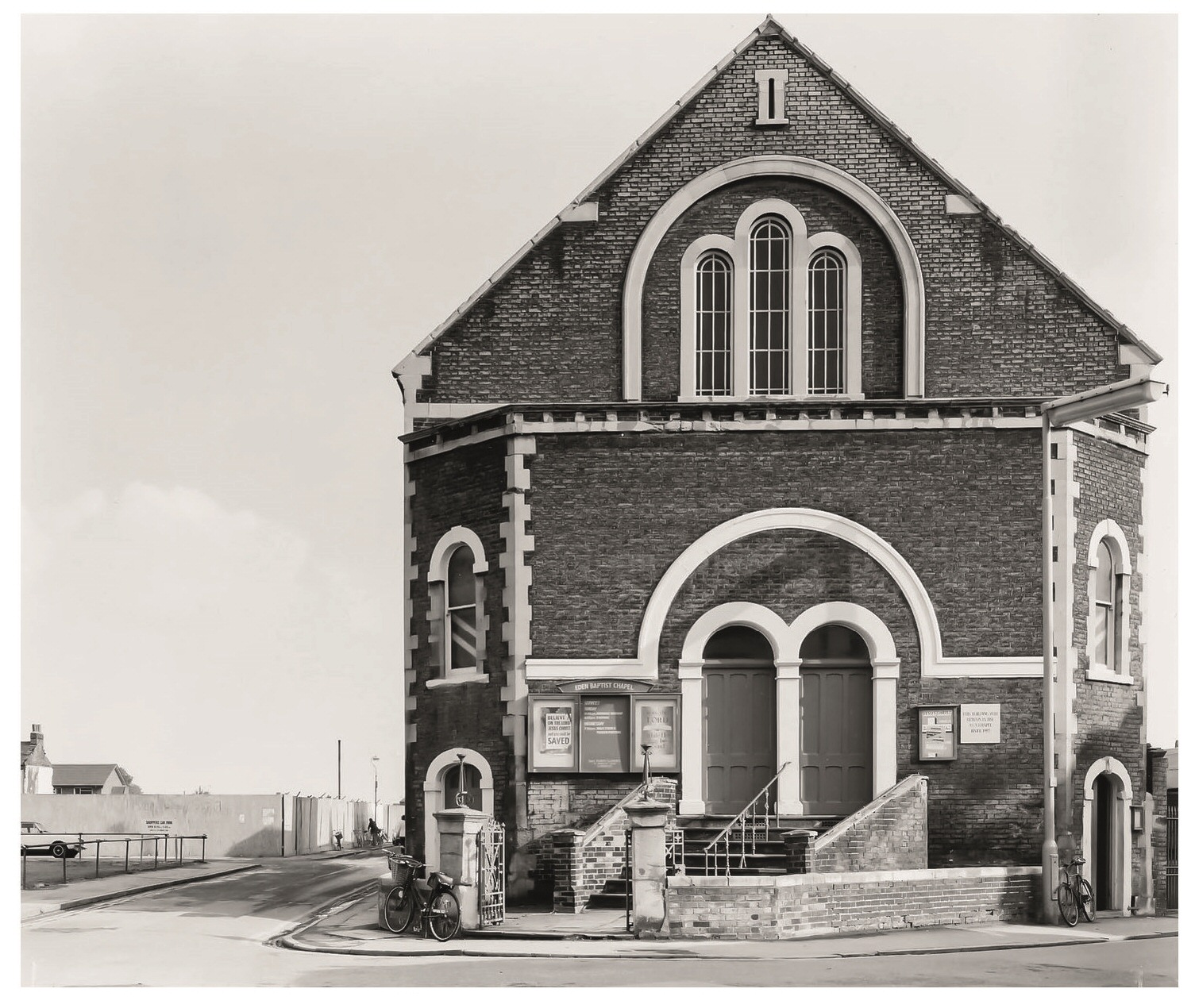
Figure 14 The Grafton Area before the shopping centre was built. Bottom: Waffles on Gold Street.
2.4.6 The map from the 1980s shows the newly constructed Grafton Centre which was built to meet the shopping needs of future generations. At the time it was felt that this could not be accommodated in the historic core of Cambridge. The centre was built over three phases and resulted in the demolition of the Victorian terraced streets highlighted in blue on the 1983 OS plan. The northern sides of Burleigh Street and Fitzroy Street were also redeveloped.
Conservation Areas
(1) 2.4.7 The Grafton Area SPD is surrounded by three Conservation Areas which form part of the 'Cambridge Conservation Area No. 1 – Central' which was originally designated in 1969, and was extended eastwards, beyond Elizabeth Way in 1993. Only very small parts of the northern part of the SPD area are included within Conservation Areas.
2.4.8 The Central Conservation Area was gradually split into smaller areas including the three which surround the Grafton Area. The Kite Conservation Area wraps around the SPD area to the north and southwestern sides. This was named after the kite-shaped piece of land which lies between Emmanuel Road, Newmarket Road and East Road. Today, the Conservation Area is a mainly residential area based on a grid pattern of streets, with two important open green spaces – New Square and Petersfield. The area was first developed on open fields and common land from around 1815 onwards.
(4) 2.4.9 The key recommendations for the Kite Conservation Area, as identified in the Conservation Area Appraisal and of relevance to the Grafton Area are:
• Designate new buildings of local interest: Consider the Tram Shed, 183 East Road, and The Snug (all in East Road) for designation.
• Enhance surrounding residential streets: Protecting houses from inappropriate alterations, care of trees and enhancements to the public realm.
• Protect positive views and skylines: Negative views, particularly of modern development within and on the edges of the Grafton Centre, and along East Road, should be mitigated and enhanced as new development comes forward.
• City Road, Paradise Road and John Street: Improvements to the existing traffic calming measures including new planting, new hard surfaces, and painting of the bollards.
• Car park next to The Tram Depot, Paradise Street: This car park would benefit from increased tree planting, better quality surface materials, new street lighting and a reduction in street signs generally.
2.4.10 The Mill Road Conservation Area forms part of the context to the south east of the study area. One of the key recommendations of particular relevance to this SPD will include preserving and enhancing the unique character of Norfolk Street which continues across East Road from Burleigh Street. This is an attractive commercial street which currently feels rather fragmented. Improvements to the buildings, public realm, traffic management, and general appearance of the area are all needed.
2.4.11 The Riverside and Stourbridge Common Conservation Area extends north of the Kite Conservation Area. This Conservation Area Appraisal recommends improvements to the roundabout at Newmarket Road and adjacent spaces and sites. There is currently an unattractive existing environment that is poor for cycles and pedestrians and dominated by traffic. Improvements to pedestrian crossings, public realm and sites around the roundabout are required.
(1) 2.4.12 Under the Planning (Listed Buildings and Conservation Areas) Act 1990, the surrounding context of the area is considered desirable to preserve or enhance for its 'special architectural or historic interest'. Early consideration would need to be given to the impact of proposals on the setting and character of the surrounding Conservation Areas as proposals come forward.
Buildings
2.4.13 The Grade II Listed 17 Fitzroy Street is located within the SPD area. This is a good example of the provincial department stores that were erected at the end of the 19th and beginning of the 20th century. The store is by the nationally recognised architect R. Frank Atkinson, a specialist in shop design. The façade is pleasing architecturally, surmounted by a large lantern, and has survived well. The light well and stairs, and associated balustrades, remain intact, which is not always to be expected in commercial premises, and endow the interior with special interest.
(1) 2.4.14 The building is of special architectural and historic interest and will be retained as part of any future re-development of the site. Consent must be sought to carry out alterations that would affect its character and setting.
(1) 2.4.15 There are other listed buildings that form part of the immediate context of the study area within the Kite Conservation Area including Christ Church, homes along Newmarket Road and around New Square which are illustrated in the Conservation Area Appraisal (2014).
Buildings of Local Interest
(1) 2.4.16 There are a number of buildings in the area surrounding the SPD area that are of local interest. These typically are terraced houses which vary in size and detail. Grafton House, located just to the north of Grafton West Car Park currently occupied by Coutts Bank is also designated as a building of local interest. Buildings of local interest do not have the same statutory protection as listed buildings but are nevertheless considered heritage assets.
Positive and negative buildings
2.4.17 The Conservation Area Appraisals give details of a number of positive buildings of townscape merit, and are shown in Figure 15. These are buildings that have been relatively unaltered where their style, detailing and building materials provides the streetscape with interest and variety. Crucially, they make a positive contribution to the special interest of the surrounding Conservation Areas and line many of the residential streets leading to the Grafton Centre.
(1) Figure 15 Heritage context
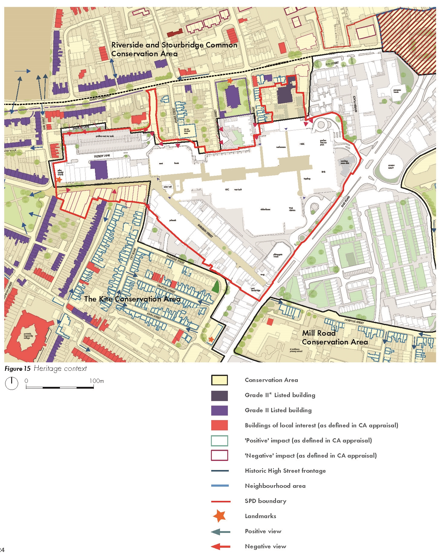
Figure 16 Photographs of Grade II listed Number 17
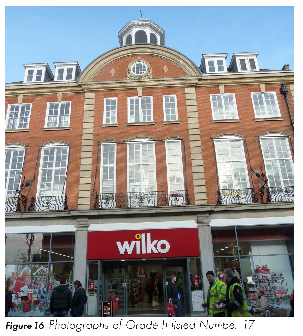
Figure 17 The setting of number 17 Fitzroy Street in 1903
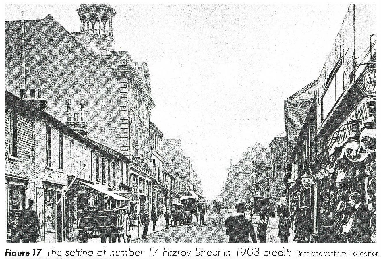
Figure 18 The setting of number 17 Fitzroy Street in 1957
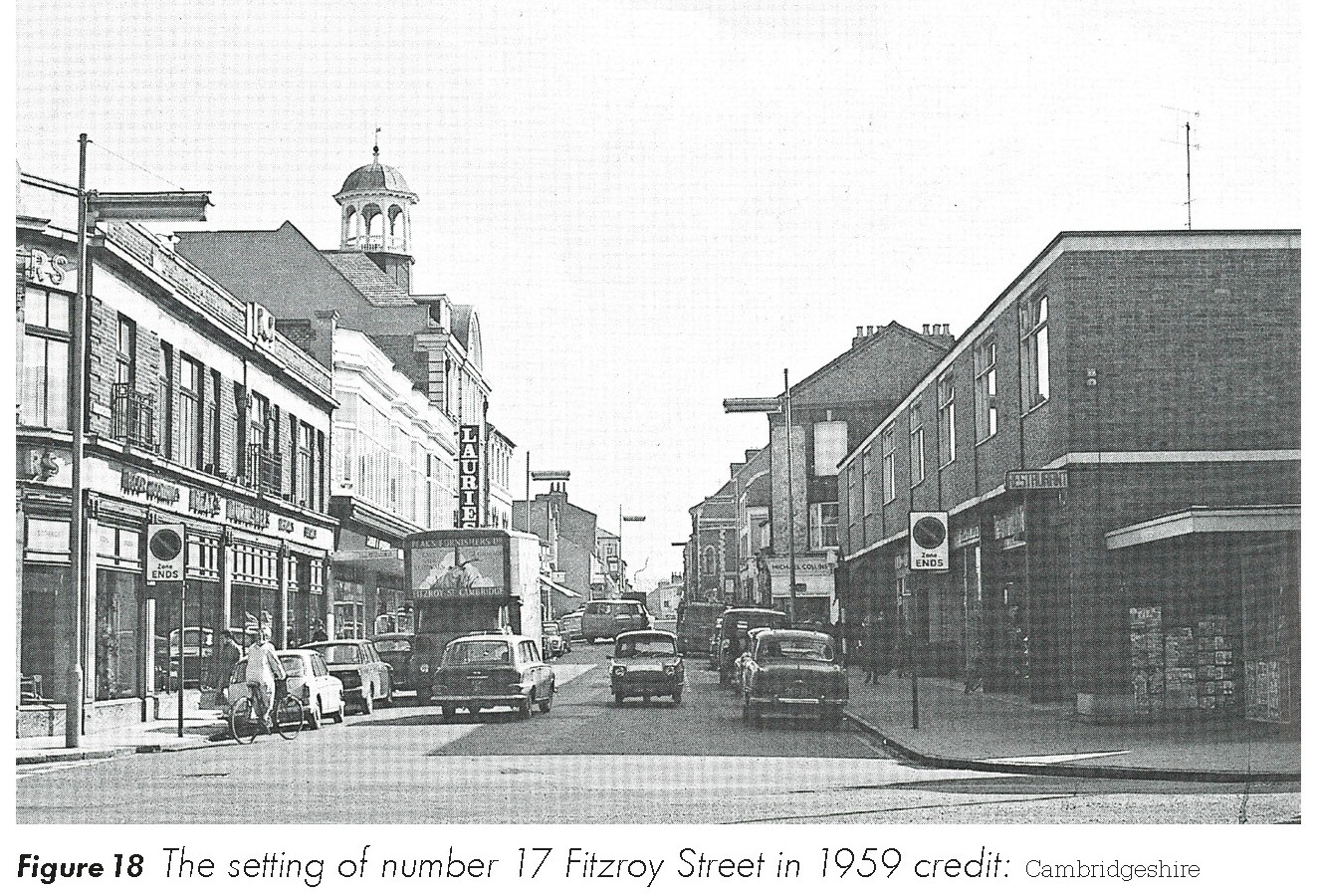
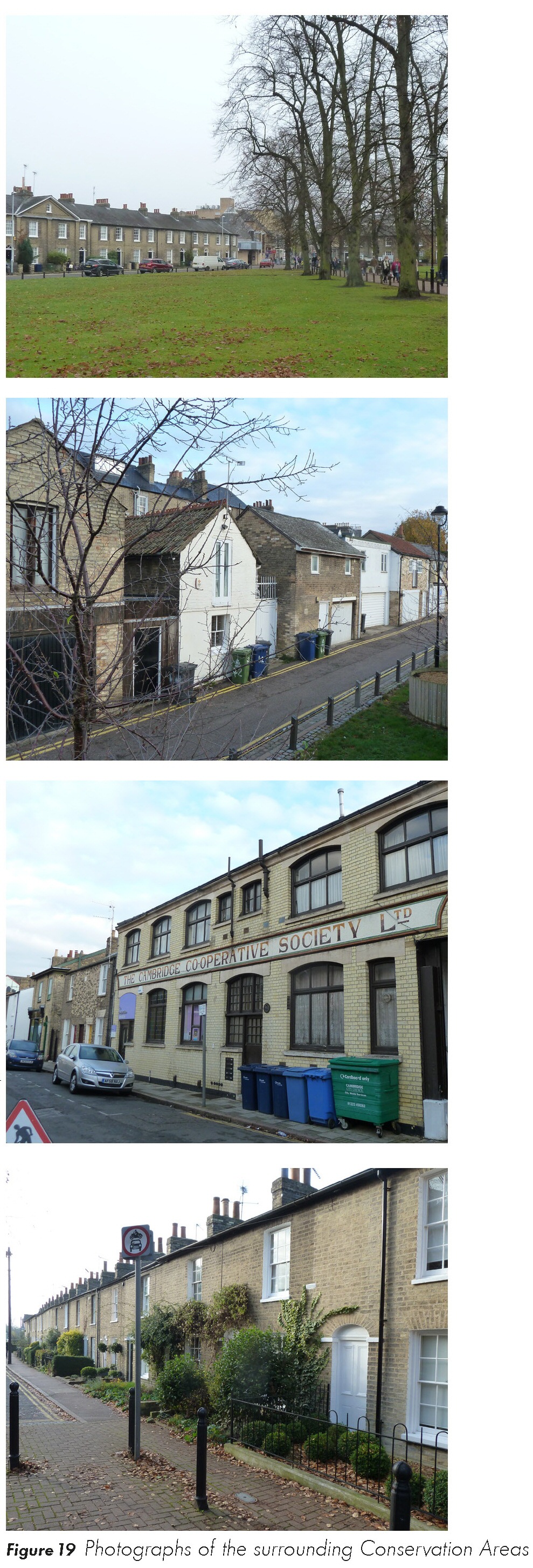
Figure 19 Photographs of the surrounding Conservation Areas
Views and landmarks
(1) 2.4.18 The Conservation Area Appraisals identify views and landmarks. Figure 15 illustrates the location of these.
(2) 2.4.19 The City Council will continue to protect the important positive views from unsympathetic development by ensuring that new development is in keeping with the character of the surrounding Conservation Areas, particularly relating to scale, general form and materials. New development should not block the positive views and skylines and longer views into and out of the Conservation Area must be carefully considered when new development is being planned. Any proposal must be in line with Policy 60: Tall Buildings and the skyline in Cambridge and associated assessment protocol.
(1) 2.4.20 Where there are negative views, particularly of modern development within and on the edges of the Grafton Centre, and along East Road, the City Council will seek to ensure that any new development seeks to mitigate the effect of these negative features.
2.5 LANDSCAPE, ENVIRONMENT AND PUBLIC REALM
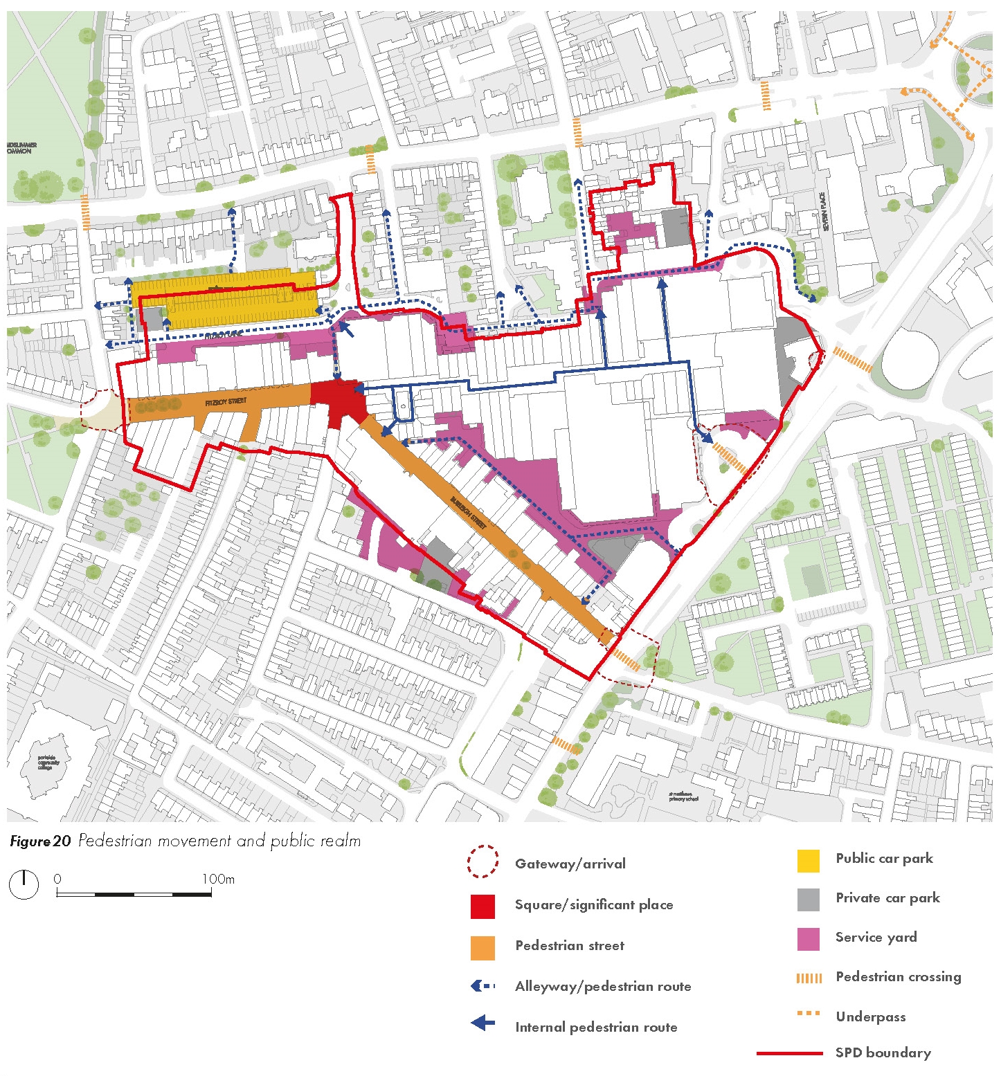
Pedestrian movement and public realm
(1) 2.5.1 The primary pedestrian route through the area is along Burleigh Street and Fitzroy Street, with routes continuing through the Grafton Centre connecting to East Road. Fitzroy Street in particular forms the principal pedestrian route between the Grafton Centre and the retail areas within the city centre and currently experiences over 21,000 two-way pedestrian movements between 7am and 7pm on a typical Saturday. Other minor pedestrian routes and alleyways connect to these key streets and out beyond the study area. A number of gateways have been identified that mark a location with a sense of arrival, many of which could be enhanced.
Figure 20 Pedestrian movement and public realm
2.5.2 There are no significant areas of open space in the study area. Large service areas and private car parks are located around the edge of the Grafton Centre which create a poor quality environment.
(3) 2.5.3 Although Burleigh Street and Fitzroy Street are pedestrianised the quality of the public realm is relatively poor with a significant amount of street clutter. Figure 21 illustrates a detailed analysis of the street environment along Fitzroy Street and illustrates the range of furniture including bins, cycle parking, street signs and A-boards.
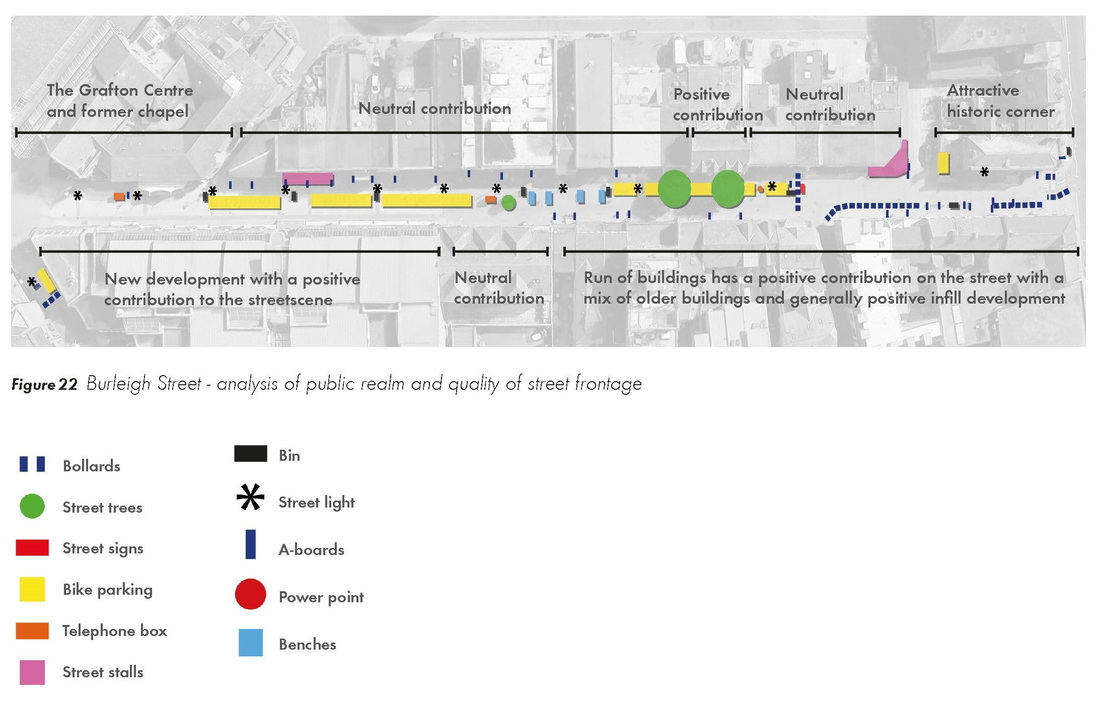
(1) 2.5.4 Figure 22 illustrates a similar environment along Burleigh Street where the pedestrian environment and walking route is disrupted by large areas of cycle parking.
Figure 21 Analysis of public realm and quality of street frontage along Fitzroy Street
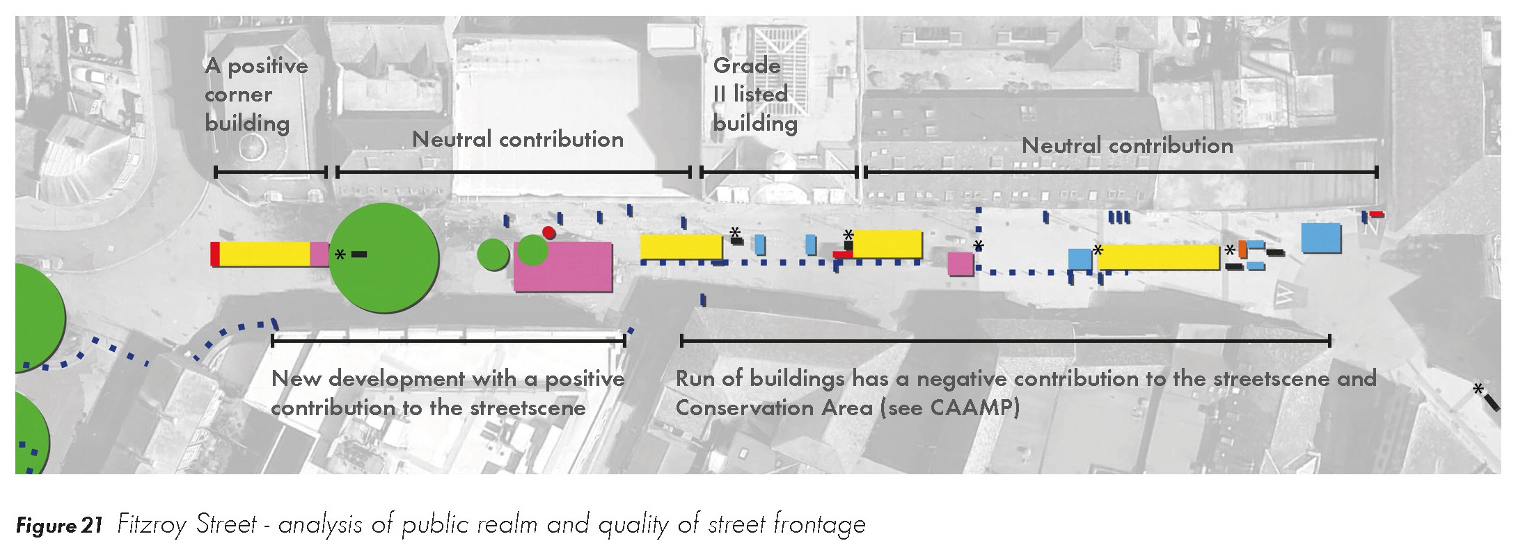
Figure 22 Analysis of public realm and quality of street frontage along Burleigh Street
(1) 2.5.5 The quality of the street frontage along these key streets varies. The eastern end of Burleigh Street has an attractive historic character which should be enhanced. Newer interventions including the Primark building and the new parade including Waitrose on Fitzroy Street have helped to raise the quality of the street environment. There may be opportunities through shopfront improvements and infill development tocontinue to raise the quality and continuity of the frontage, particularly focused in areas where the built fabric is of a lower or neutral quality.
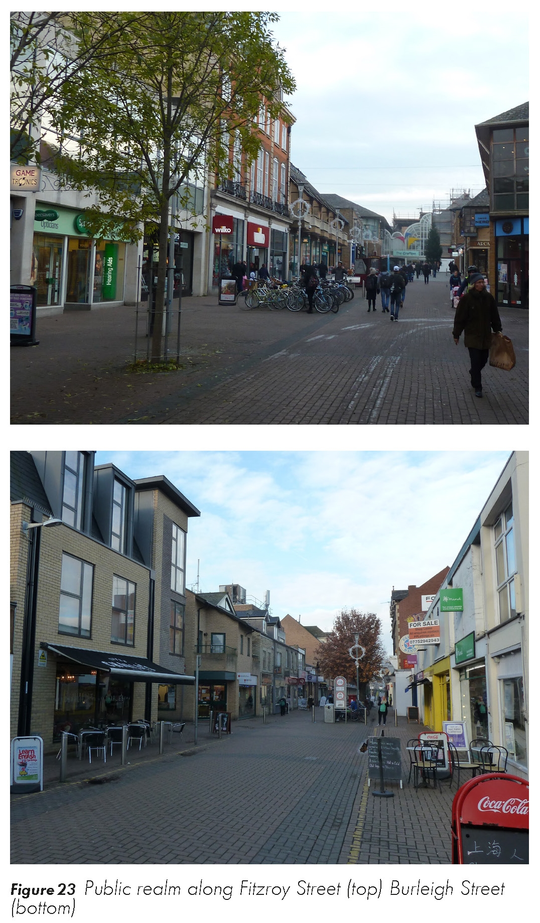
Figure 23 Public realm along Fitzroy Street (top) Burleigh Street (bottom)
Open space
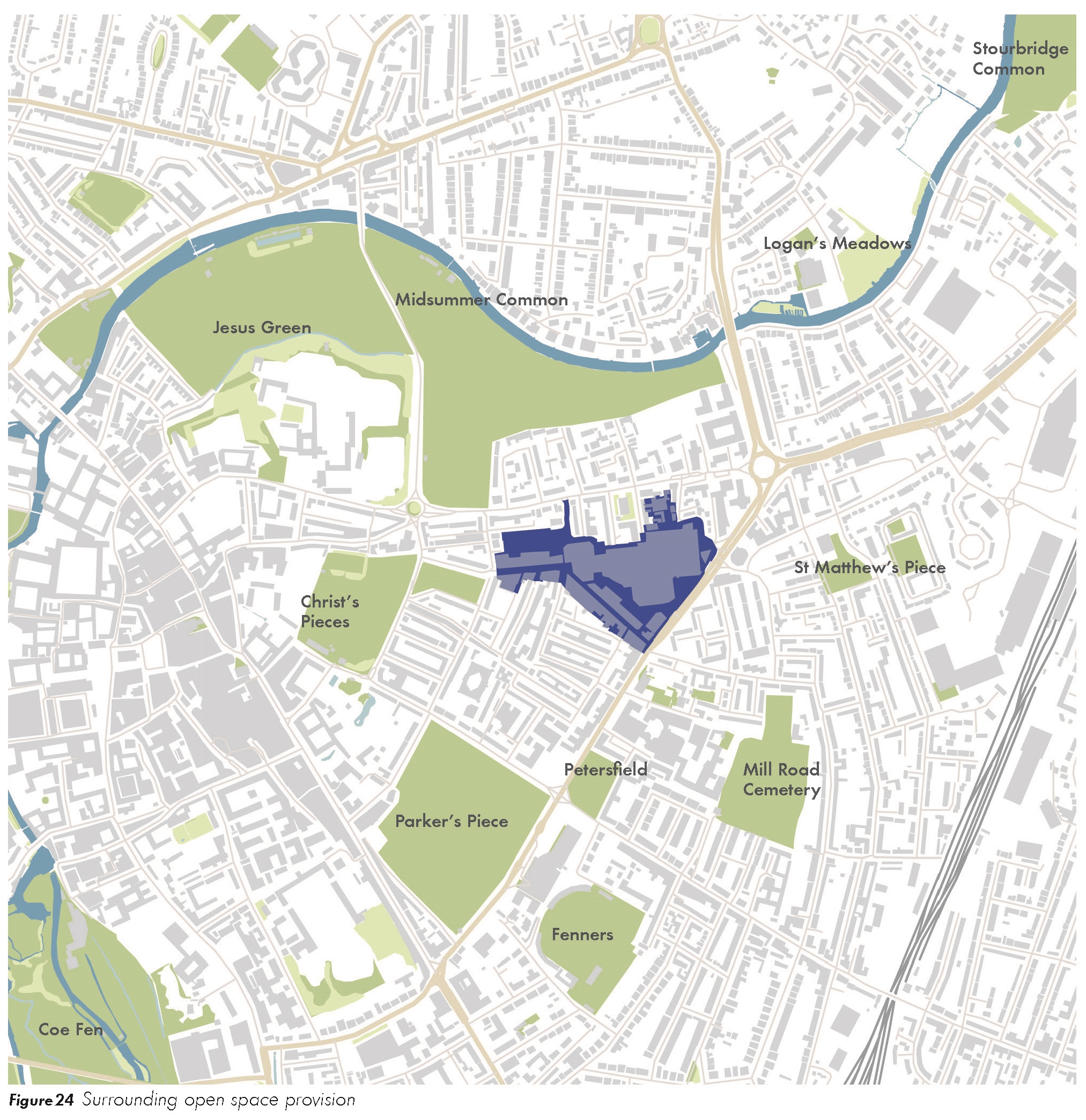
(1) 2.5.6 There is no green open space within the SPD area and limited hard landscaped space that could be described as a square or formal public space. However, there is a large amount of accessible green space in the surrounding area as illustrated in Figure 24. New Square and Christ's Pieces are the nearest open spaces which begin immediately to the west of the SPD area and provide an attractive gateway to the site and route from the town centre. The open spaces in the area are:
• New Square – 0.75ha (2 min walk), green open space with planting.
• Christ's Pieces – 0.6ha (5 min walk), playground facilities for children.
• Jesus Green and Midsummer Common - 13.8ha (5 min walk)
• Petersfield – 0.9ha (9 min walk)
• Parker's Piece – 9ha (10 min walk), green common near the town centre for recreational activities such as football and cricket.
• St Matthew's Piece - 0.6ha (9 min walk)
Figure 24 Surrounding open space provision
(2) 2.5.7 The SPD presents an opportunity to improve the public realm, increase tree planting and provide enhanced areas of hard landscaping.
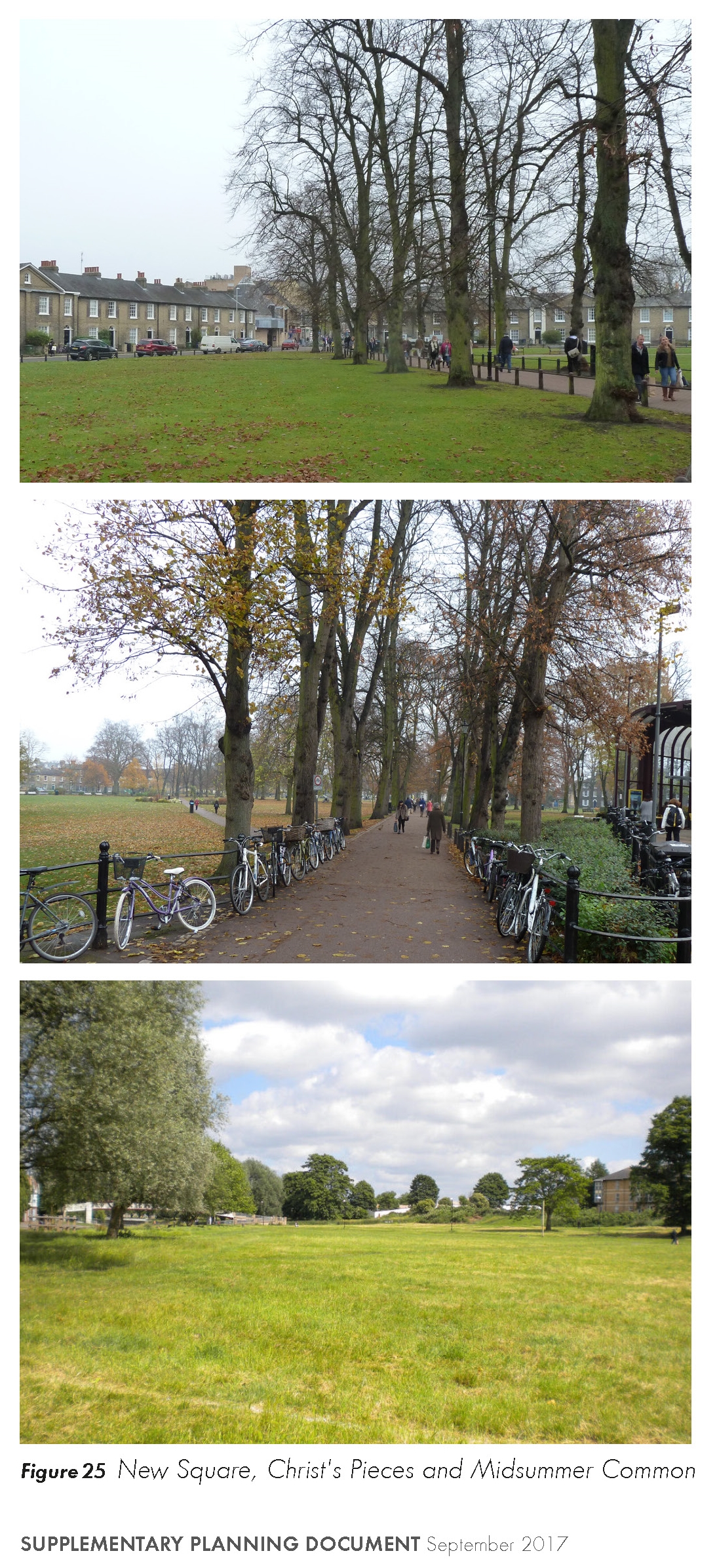
Figure 25 New Square, Christ's Pieces and Midsummer Common
Trees and landscape
(3) 2.5.8 Trees make a significant contribution to the appearance and character of surrounding streets and spaces. Mature trees surround New Square and form an attractive greened gateway to Fitzroy Street and the SPD area. Similarly, there are a number of more mature trees outside of the SPD area along Newmarket Road and around Christ Church which enhance the setting of this listed building.
(2) 2.5.9 Due to the bulk and massing of the Grafton Centre there is a relative lack of large trees within the SPD area. There are a number of more mature trees along Fitzroy Street but no areas of landscaping or green space within the study area. Figure 26 illustrates existing trees in and around the AOMC.
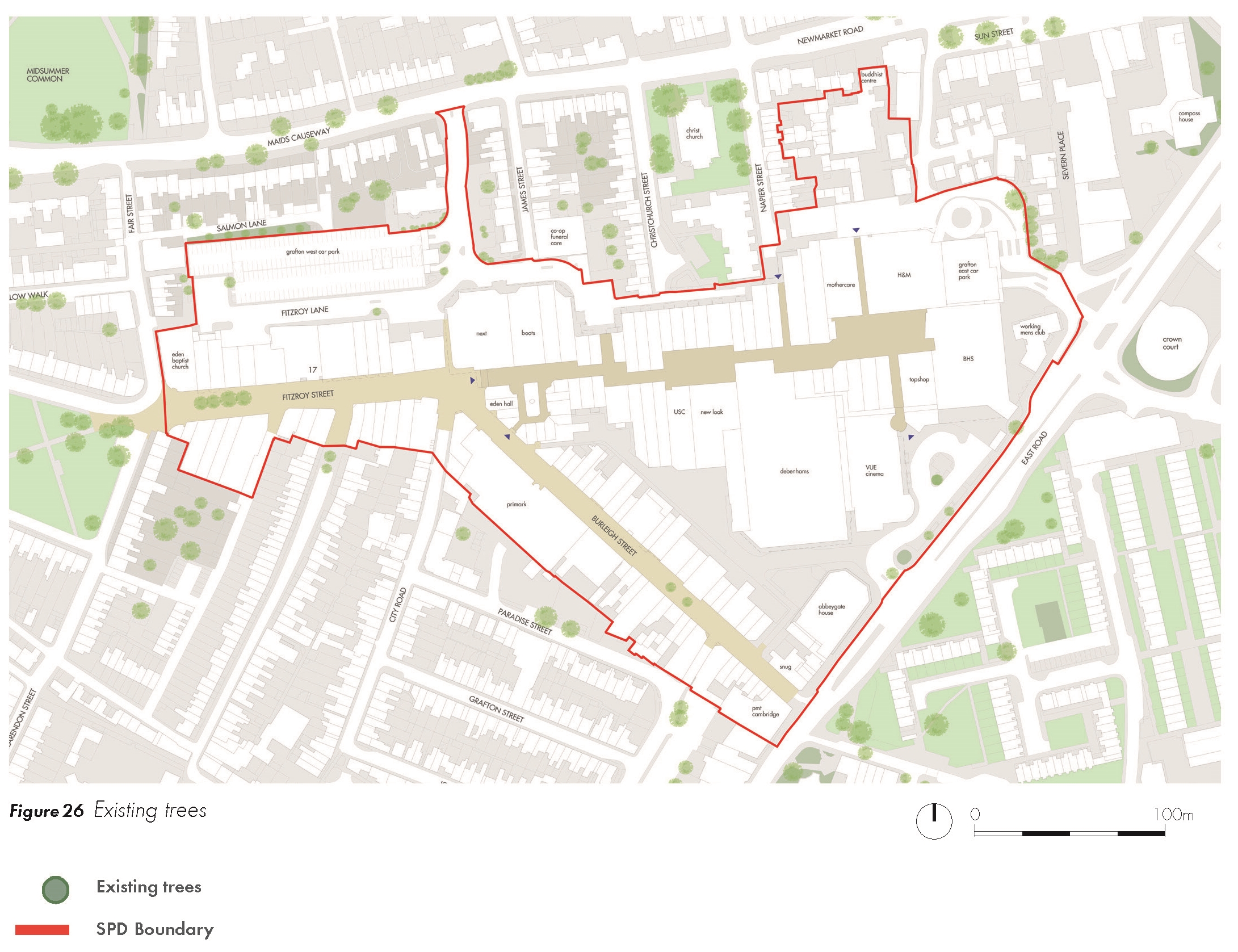
2.6 PUBLIC CONSULTATION
(6) 2.6.1 This section summarises the consultation that has taken place as part of the Grafton Area SPD process.
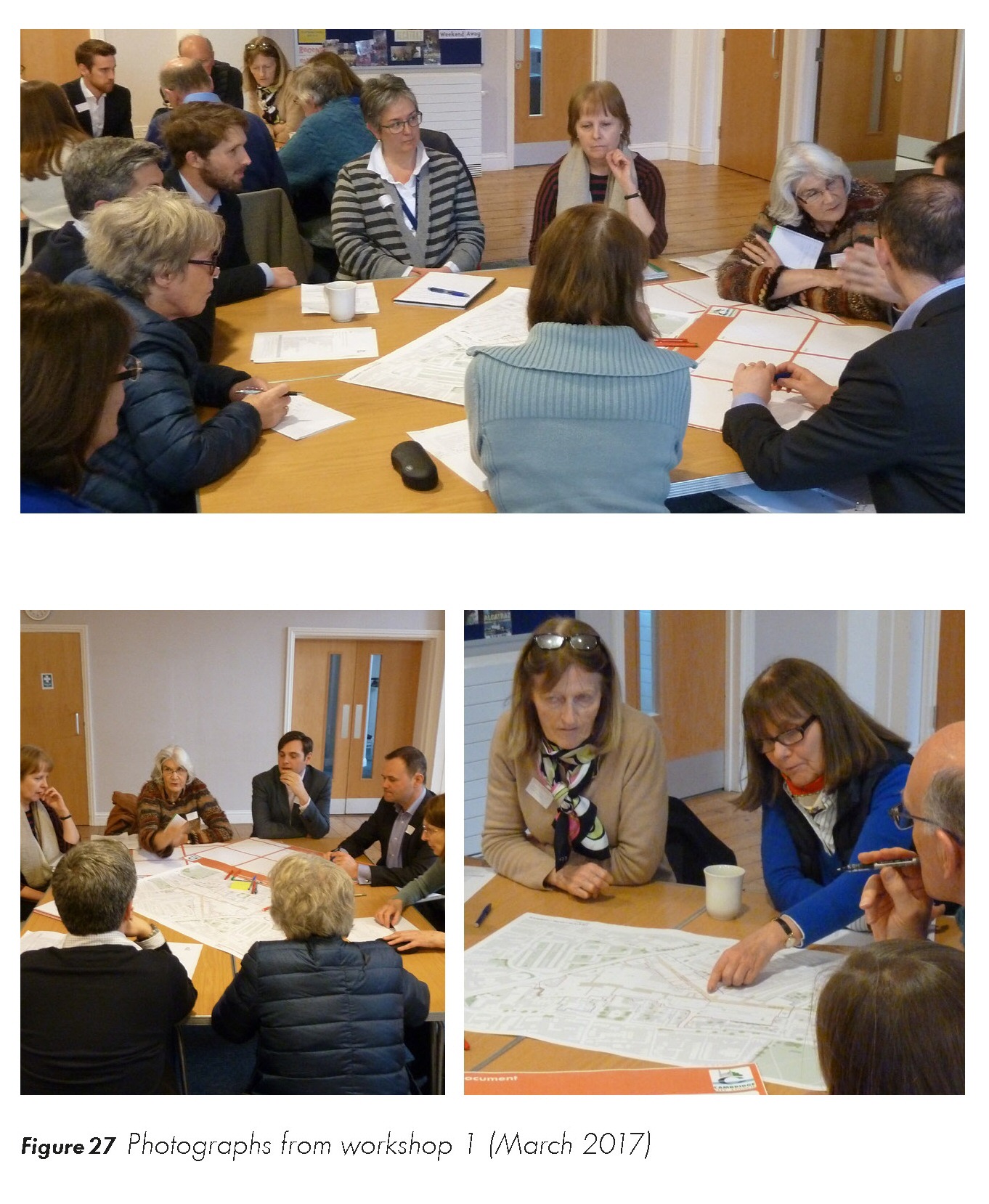
Stakeholder Workshop 1
(2) 2.6.2 A workshop was held in March 2017 to explore the context for the study and identify emerging opportunities for the area. Local residents and stakeholders were able to set out their priorities for the area and discuss any concerns. These are summarised under the following themes:
Land use
• Opportunities to enhance the retail, food, leisure, community and culture offer.
• Support for uses that encourage activity in the area into the evening.
• Keen to see independent shops and an enhanced offer of artisan food shops. Retain the fruit and vegetable stall currently located on Fitzroy Street.
• Support for more homes in the area, less support for student housing.
• Support for office space along East Road and Burleigh Place.
• Design buildings in a flexible way so that uses can evolve in the future.
Design
• Reintroduce the old Fitzroy Street connection in the longer term.
• Create distinct areas of character with carefully designed buildings in keeping with the local area.
• The 'human scale' of the area is important - surrounded by residential streets.
• Open spaces / public realm
• Improve public realm and reduce clutter along Fitzroy and Burleigh Streets.
• Introduce greening at higher levels as well as street tree planting.
• Create spaces to relax and dwell – more seating and spaces for activities and events.
• Improve the environment and quality of pedestrian crossings along East Road.
(1) Access and movement
• Service areas were felt to be too large and should be redeveloped where feasible.
• Review the hours in which deliveries are permitted.
• Car parks were felt to be under-utlised but on-street car parking is well used and residential permits should be extended.
• Long-stay cycle parking locations should be identified to help reduce clutter along Fitzroy and Burleigh Streets.
• Review if East Road needs to be a dualcarriageway as it has a negative impact on the environment. Invest in the quality of the public realm including surfacing and pedestrian crossings.
• Buses should stop on lay-bys along East Road.
• Some residents had safety concerns about using certain routes outside of trading hours.
Figure 27 Photographs from workshop 1 (March 2017)
Stakeholder Workshop 2
2.6.3 A second workshop took place in April 2017 which was attended by a range of stakeholders and residents. The purpose of the workshop was to provide a summary of outcomes from the first workshop, and to test and review the emerging proposals which will inform the production of the draft SPD. Feedback from the three workshop groups are summarised as follows:
Land use
• Improve range of uses, with focus on 'experiential' uses and make more of destination.
• More leisure activity.
• Connect day and night time activity.
Public realm and landscape
• Improving public realm along Fitzroy Street/ Burleigh Street should encourage night time activities.
• Fitzroy/Burleigh Street are poor for partially sighted.
• Long stay cycle parking provision.
• Some wider spaces helpful.
• Improve connections to Beehive Centre.
Building design and heights
• Intensification of height and floor space to encourage redevelopment.
• Heights are very sensitive - townscape analysis will be required for East Road.
• Activation of ground floors is important.
• Design quality is paramount.
• Address the edges of the centre and the surroundings.
(2) Character and heritage
• Enhance the surrounding Kite area.
• Improve relationship and connection with residential streets such as Napier Street and Christchurch Street.
• 'Independent quarter', including food and drink on Burleigh Street including night time economy.
• Add vibrancy through small scale redevelopment on Burleigh Street.
• Catalyst used to encourage evening uses.
• Create active frontages to north side of Burleigh Street on Burleigh Place.
• Need smaller retail units as well as bigger plots which focus on the city offer.
(2) Access and servicing
• Traffic is a big issue.
• Consider East Road options to reduce number of lanes.
• Supportive of network of historic streets.
• Need a balanced approach to servicing, encouraging a reduction and more smaller vehicles, potentially on-street.
• Interest in cycling on Fitzroy Street / Burleigh Street.
• Certain routes considered unsafe at night, introduce other uses such as office, residential and leisure uses.
• Different views about the role and function of Fitzroy Street in terms of proposals for streetscape improvements and roadway.
• Click & collect to encourage greater footfall.
• Careful to ensure it does not become 'rat run' for taxis.
• Ensure cycle parking is not to the detriment of other uses/activities.
• Consider night time route through Grafton Centre.
• Consider pop-up uses.
• Provide a Grand Arcade style cycle park.
(1) Sustainability
• Important to allow flexibility to future-proof any development.
• Emphasis on sustainable design.
• Reduce car use.
Delivery
• Emphasis on proposals outside of the core Legal and General ownership and also Burleigh Street.
Figure 28 Photographs from workshop 2 (April 2017)

Exhibition - The Grafton Centre
2.6.4 An exhibition was held in the Grafton Centre in May 2017 to help explain the changes that are currently underway to the centre and illustrate how it will look in the future. The exhibition also included a banner that introduced the SPD process and the timeline for the project, advertising the formal public consultation in Summer 2017.
Figure 29 Exhibition at the Grafton (May 2017)
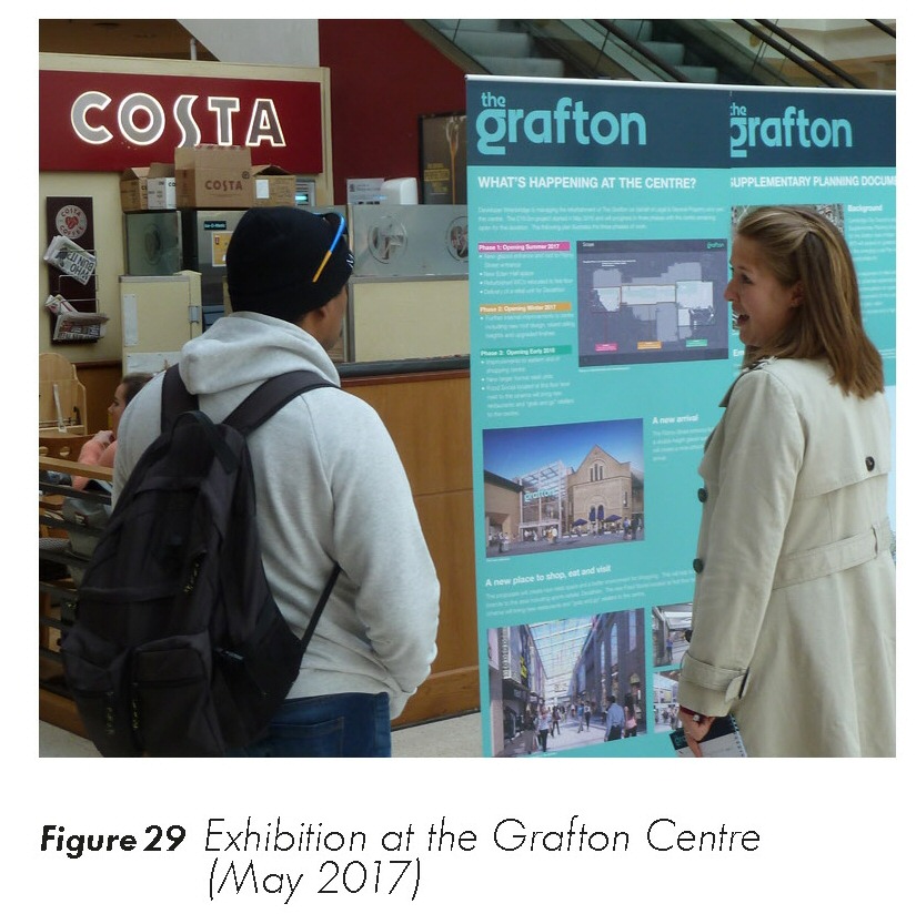
2.6.5 Of the 84 people who stopped to consider the proposals, there was significant interest in the works which are currently on-site or due to progress soon. Participants were keen to identify the types of operator who would be suitable, and there was a broad consensus about the need for more emphasis on food and leisure. People were interested in the longer-term opportunities for change and supported the concept of strengthening Fitzroy Street, Burleigh Street and East Street, alongside the longer-term proposals for change, including greater emphasis on street-based retailing.
2.7 Summary of opportunities and constraints
(1) Figure 30 Summary of the existing experience of the Grafton Area
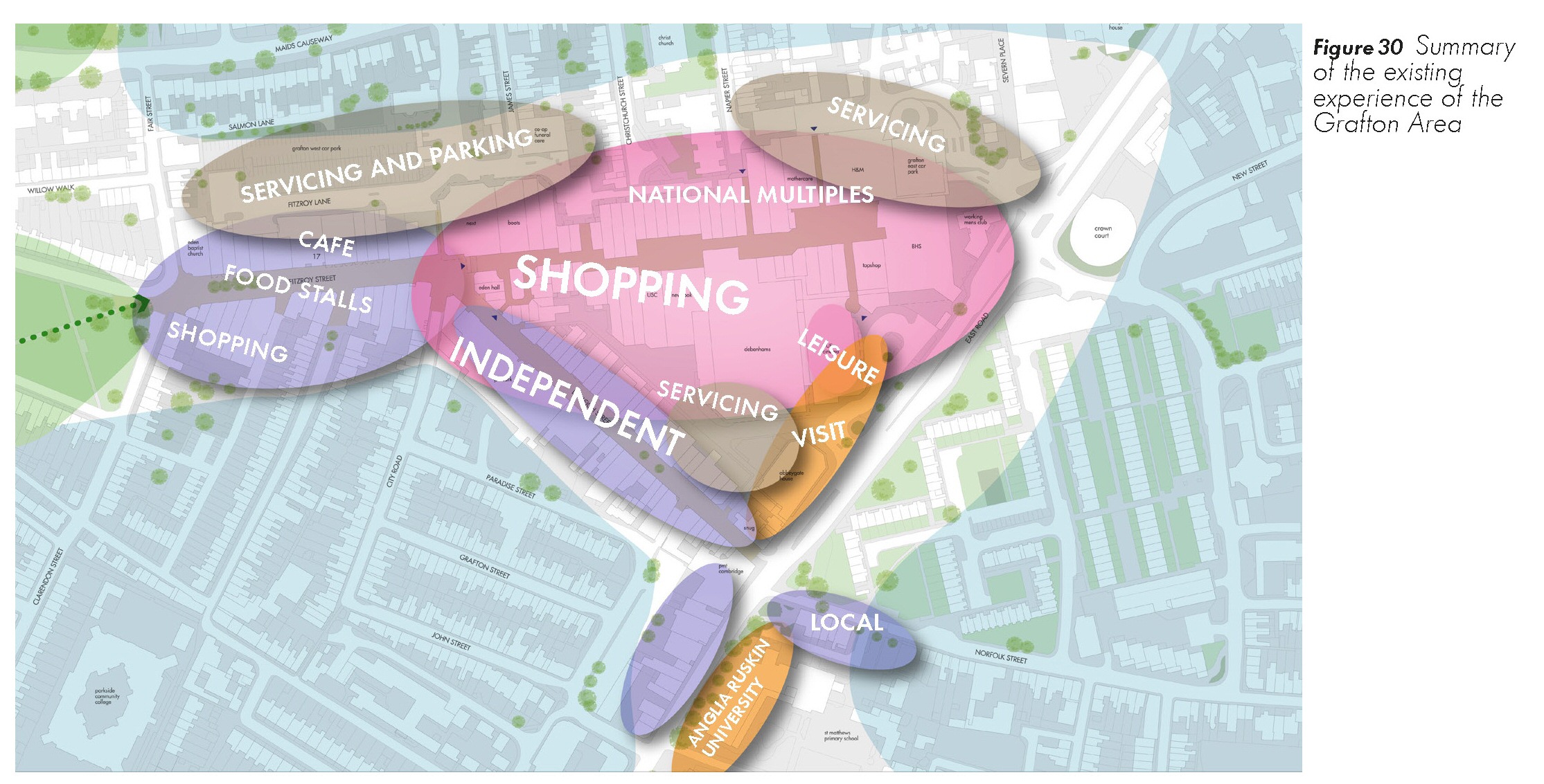
Figure 31 Summary of opportunities for future activities and character
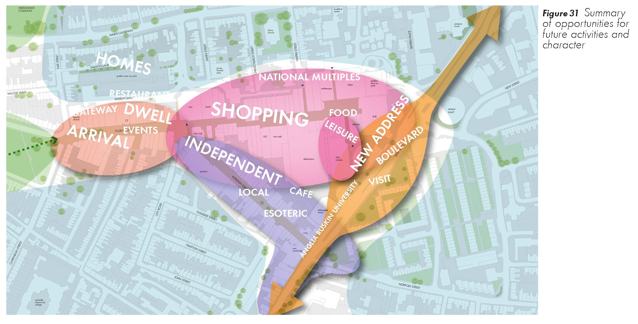
2.7.1 This chapter has highlighted a number of key constraints and opportunities that should be taken into consideration for future development within the Grafton Area SPD. Figure 30 helps to illustrate a summary of the existing context in terms of uses and experience. This highlights the dominance of the service areas and fragmented character of the existing SPD area. Figure 31 helps to set a vision for future activities and character within the Grafton Area which is more integrated and cohesive.
Issues
(4) 2.7.2 The SPD area has the following key issues:
• The Grafton Centre has a significant impact on the setting of adjacent streets and Conservation Areas.
• The SPD area still suffers from the loss of grain and severance of streets and connections as a result of the development of the centre.
• Fitzroy Street and Burleigh Streets form weak destinations and thresholds, and could play a stronger role for the local area and the city.
• The Grafton Centre is let down by poor edges and un-welcoming spaces which create a negative perception and hinder movement.
• Public realm and spaces suffer from competing demands and a lack of clarity including servicing, cycling and street furniture.
• The area lacks diversity of uses which constrains the level of activity and footfall through the day.
Opportunities
(1) 2.7.3 The opportunities within the SPD area have been organised into four categories.
(1) 2.7.4 Landscape and Public realm:
• Improve and co-ordinate the public realm along Burleigh Street and Fitzroy Street, integrating existing trees and enhancing the sense of arrival.
• Create a better frontage and pedestrian environment along East Road that is no longer dominated by traffic.
(5) 2.7.5 Movement and access:
• Adapt and redevelop the service areas to the Grafton Centre to better integrate the shopping centre into its context and provide effective, efficient servicing.
• Review the car parking requirement and consider the redevelopment of the Grafton West Car Park.
2.7.6 Scale, massing and built form:
• A series of sites along East Road to provide more active frontages and introduce new uses along a new boulevard.
• Redevelopment of sites surrounding the Grafton Centre of an appropriate scale and massing.
• Within the SPD area there will be opportunities to increase the comparison retail and leisure space with new residential and student accommodation on the upper floors.