Land North of Cherry Hinton SPD
5. Framework Principles and MasterPlan
Overview
(1) This chapter provides planning and design guidance on how the development principles will be used to guide future planning applications.
The main guiding principles are defined in a series of parameter drawings with supporting text. These are supported by a range of illustrative drawings which depict how the principles could be realised to create a high quality development.
As well as following the planning and design guidance set out in this SPD, any future planning applications should comply with extant policies contained within the Cambridge East AAP, the Cambridge Local Plan (2006) and South Cambridgeshire Core Strategy (2007) and their replacements, which are currently the subject of examination.
This chapter is structured as follows:
- Summary of consultation to date
- Movement
- Environmental considerations and sustainability
- Landscape and open space
- Land uses
- Character and form
- Environmental considerations and sustainability
- Planning obligations
- Overview of key development principles
Summary of consultation to date: SPD workshops
The principles set out in this section have been informed by consultation events and feedback. A summary of the key findings are provided below. Findings have informed the development principles set out on the following pages.
(1) A number of key stakeholders were identified and included neighbourhood groups, local councillors and key councillors from Cambridge City Council and South Cambridgeshire District Council.
(1) Two stakeholder workshops were held in preparation for the drafting of the SPD:
- Workshop 1. Key stakeholders were informed that the Site was being brought forward as part of the local plan and were invited to attend a Planning Workshop. The workshop was held at St. Andrew's Church Centre on 9th March 2017.
- Workshop 2. Having reviewed and input feedback, key
stakeholders were invited to a follow up planning workshop.
The workshop was held on 7th April 2017 at St. Andrew's
Church Centre.
(1) Movement and transport:
Spine Road - strong desire to avoid rat running
Concern over congestion caused by development
Cycling - consensus that cycle routes could play an important role in minimising traffic through the development and providing sustainable access to key destinations and local facilities
Public transport - lack of bus transport in the village
Footpaths - questions raised over the future of the footpath
through the site
(1) Social infrastructure:
Primary school should be located near the local centre
Secondary school should be placed carefully in relation to transport routes, possibly on the edge of development
Allotments - should be located between the built development and existing village
Community facilities - extra would be needed; a square or open space could hold community events
Local centre ingredients - suggestions included a pub, shop,
greengrocer, library, pharmacy, cafe, charity shops,
community space, health centre, faith space, hotel, meeting
rooms
Buffer zone between the development site and airport land should be lined with vegetation
There should be a clear green edge with Teversham
Airport - felt to be an interesting view
Green space should integrate recreational opportunities and should maintain views to countryside
Urban edge - careful thought should be given to the
interaction of the urban edge with the countryside
Character - a mix of styles are found in Cherry Hinton
Density - view that apartments should not extend beyond 4/5 storeys; higher density could be close to transport interchanges
Mixed-use considered a positive
(1) Housing:
Open spaces should be prioritised over gardens
Height - 4/5 storey maximum
Movement
(2) The development of a transport and movement strategy for the site relies on the relationship of several key components. It is important that these work together to encourage walking, cycling and the use of public transport as the most desirable modes of travel.
The components considered in this section are:
- Access and primary routes
- Primary street options
- Cycle and pedestrian movement
- Public transport
- Cars and parking
(2) Relevant planning policies include CEAAP (Cambridge East Area Action Plan 2008) policy CE/10 (road infrastructure), policy CE/11 (alternative modes and parking), CLP (Cambridge Local Plan 2014) policy 80 (Supporting sustainable access), CLP policy 81 (mitigating transport impact), and SCLP (Proposed Submission South Cambridge Local Plan 2013) policy TI/2 (Planning for sustainable transport) prioritise sustainable travel methods, and seek to ensure development mitigates transport impacts.
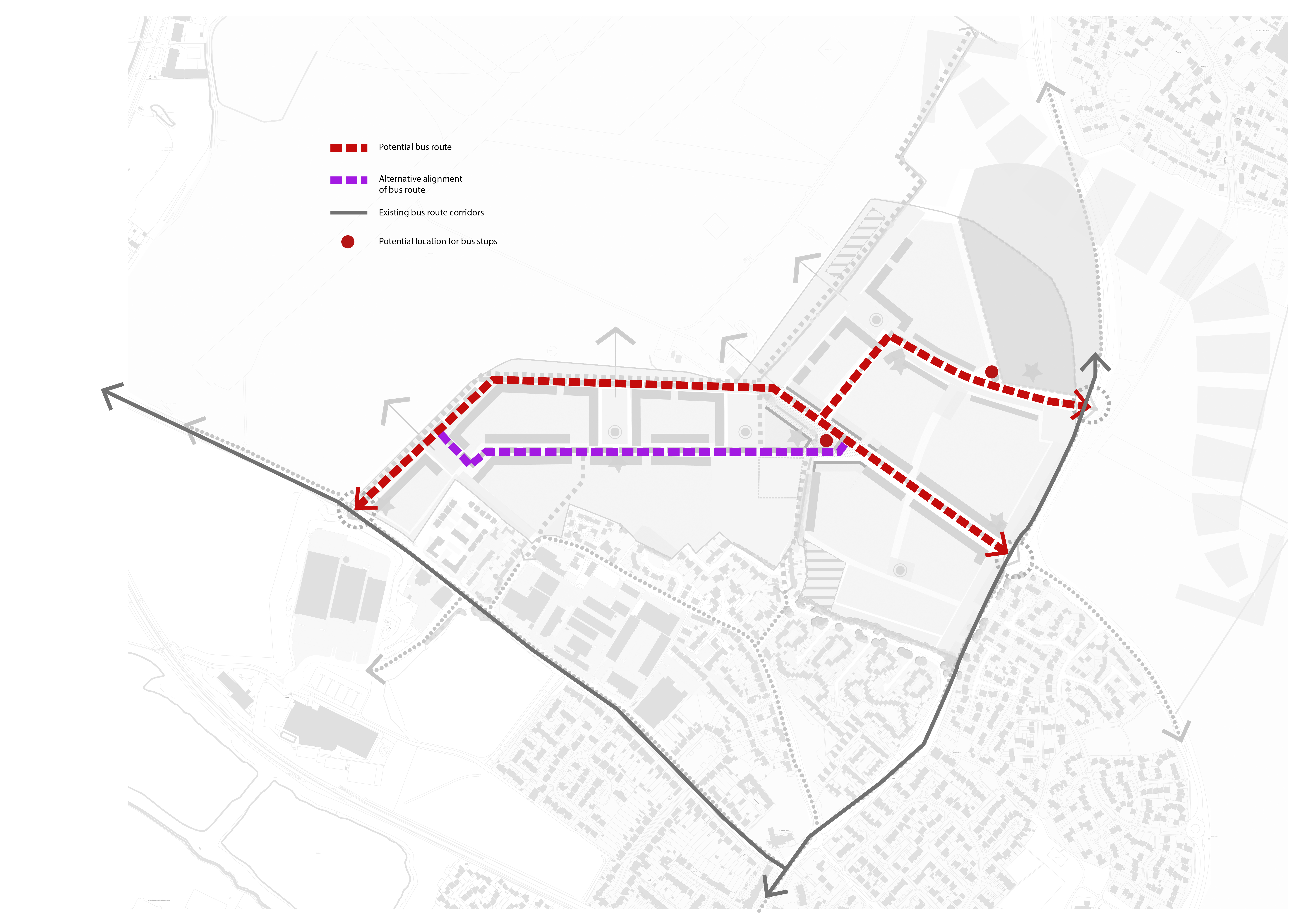
(8) The movement strategy, as illustrated in figure 39, capitalises on the unique opportunity that the location of the site offers in the east of Cambridge, promoting sustainable travel for existing and future residents in the area. Three key principles that are incorporated in the strategy include:
- Reducing the need to travel by car within the development through offering excellent permeability within the site for pedestrians, cyclists and public transport.
- Encouraging journeys on foot and by bicycle through providing direct connections to important routes off-site including Cherry Hinton High Street, Airport Way, Coldham's Lane and the Tins route.
- Encouraging travel by bus by ensuring main routes within the site accommodate buses and are designed to maximise the number of residents located within walking distance of a regular service.
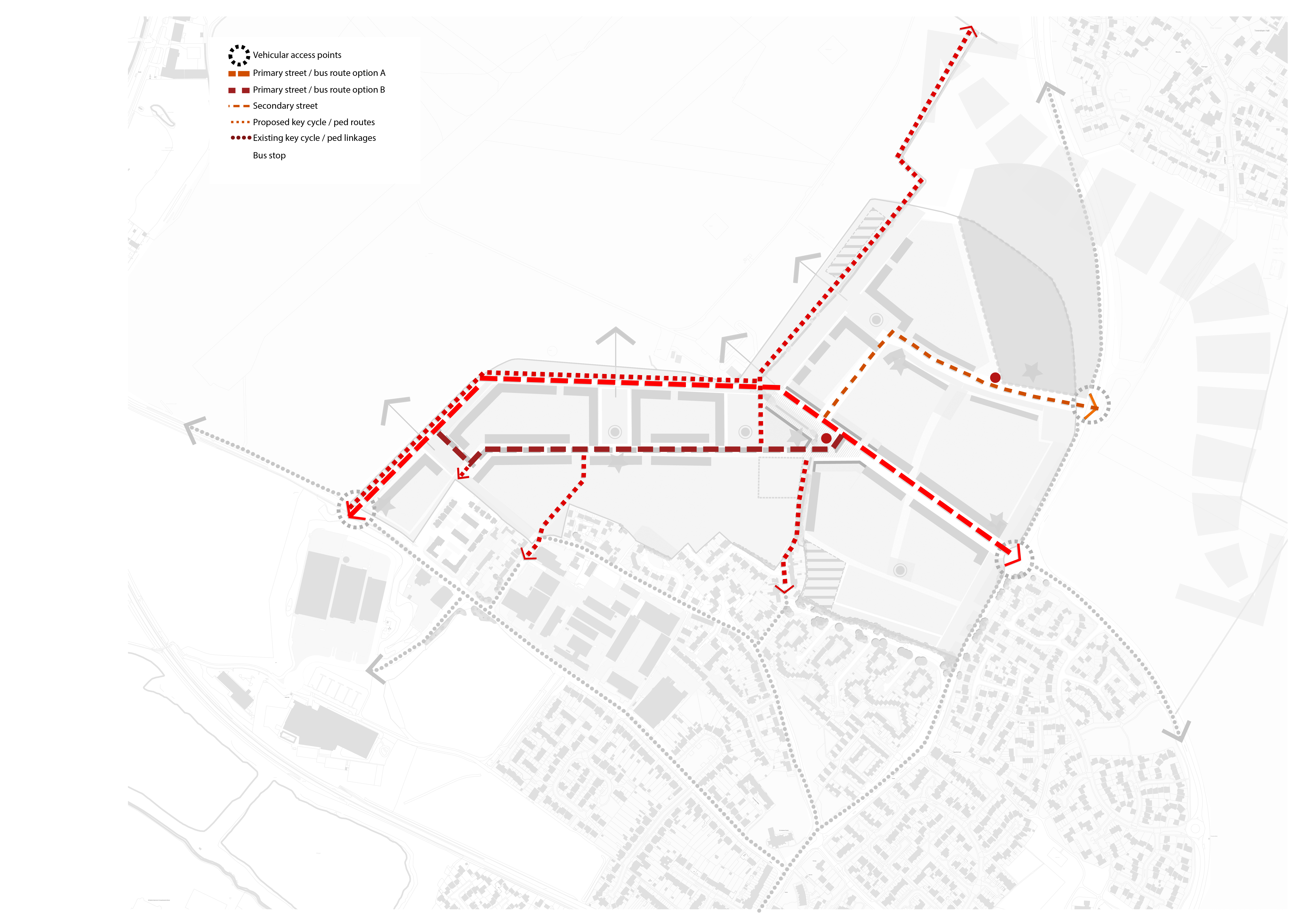
(3) As shown in figure 40, vehicular access to the site will be from Coldhams Lane and Cherry Hinton Road / Airport Way, as required by CLP policy 12 (R47) and SCDC policy SS/3.
(5) Any future planning application will need to demonstrate appropriate capacity at each of the access junctions for all vehicles, including emergency and refuse vehicules, travelling to and from the site through provision of a Transport Assessment. This assessment should also consider the development impacts on the local highway network (including Cherry Hinton Road and Coldhams Lane), and local junctions (Coldhams Lane / High Street, Coldham's Lane / Barnwell Drive).
(1) Developers will be encouraged to incorporate a traffic calmed environment using street design and intersecting cross routes to create a natural reduction in speeds. Shared surface environments should be employed. The spine road speed limit should be agreed with Highways Development Control however a design speed of below 20mph is considered most appropriate.

As set out in part 3 of policy 12, the master plan for site R47, 'will make provision for a primary and secondary school, a local centre with community hub, open space and a spine road connecting Coldham's Lane with Cherry Hinton Road. Vehicular access to the site will only be permitted via the new spine road unless needed for emergency access'.
(2) There has been discussion through the initial technical work and stakeholder workshops on the route, form and function of the spine road. Two primary street options are presented which show different ways that the spine road could form a flexible primary route through the site. The requirements of the final spine road design will be determined by Cambridge County Council and local authorities through the planning application process.
Consideration should be given to landscape when deciding on the design of primary routes in order to ensure the usability of open spaces within the site.
(1) Elements to consider include, but are not restricted to, the following:
- The visual impact of the design
- Impact on drainage
- The amenity value of adjoining open spaces
- Impact on residential amenity
- The location of the relocated gas main.
Main vehicular access points to the Site
(1) Weston Homes have obtained planning permission for up to 57 homes on land at Hatherdene Close, near to the western access into the Site. The Weston Homes development will become the immediate eastern boundary to the site in this location. Housing proposed on this site will be accessed via a new priority junction from Coldham's Lane and in order to maximise spacing between the two junctions, the Coldham's Lane access to the Land North of Cherry Hinton site is required to be located to the west of the site boundary, on Coldhams Lane. Local design guidance recommends minimum spacing between junctions on the same side of the road, to ensure that the visibility splays at each of the junctions do not interfere and result in safety issues. The visibility splays agreed for the Weston Homes site were 4.5m x 120m and therefore the location of the access to the far west of the boundary seeks to reduce the potential for impact on the Weston Homes visibility splay.
The County Council has recommended that the main access from the eastern side of the site is to be from the existing roundabout at the Cherry Hinton Road / Gazelle Way. This is due to the fact that the existing roundabout already requires vehicles to slow down and presents an opportunity for a main access point that has the least impact on vehicular movements as well as keeping this access point within the urban area of the city.
(3) There are as such two options for a spine road connecting these two main access points. The first of these options (Option A adjacent) runs the main spine road through the site along the northern boundary of the site; the second brings the main spine road away from the northern boundary and through the heart of the site (Option B adjacent).
(2) A spine road which runs through the local centre of the site and continues along the northern perimeter allowing the provision of direct, traffic free or low traffic cycle and pedestrian routes through the central belt of the site.
- Allows for a traffic calmed / free central spine through residential areas
- Aids in reducing the noise impact on residential areas by keeping noise generating activities along the airport edge, with a landscape park buffer to the residential blocks
- Opportunity to integrate the new gas main along the
footpaths and verges, keeping landscaped areas and parks free
from constraint
(1) Disadvantages
- Requires a thoughtful design considerations for traffic calming, to ensure it does not turn into a bypass peripheral route
- Requires consideration of landscape design to achieve high quality park and open spaces
(1) A spine road which runs through the centre of the site allowing the provision of traffic-free cycle and pedestrian routes along the perimeter of the site rather than through the centre.
(3) For Options A and B, there is also the possibility to introduce a bus gate along the spine road which would offer the opportunity to only allow through-connections between Cherry Hinton Road and Coldham's Lane for buses, pedestrians and cyclists.
Figure 41: Primary street options A
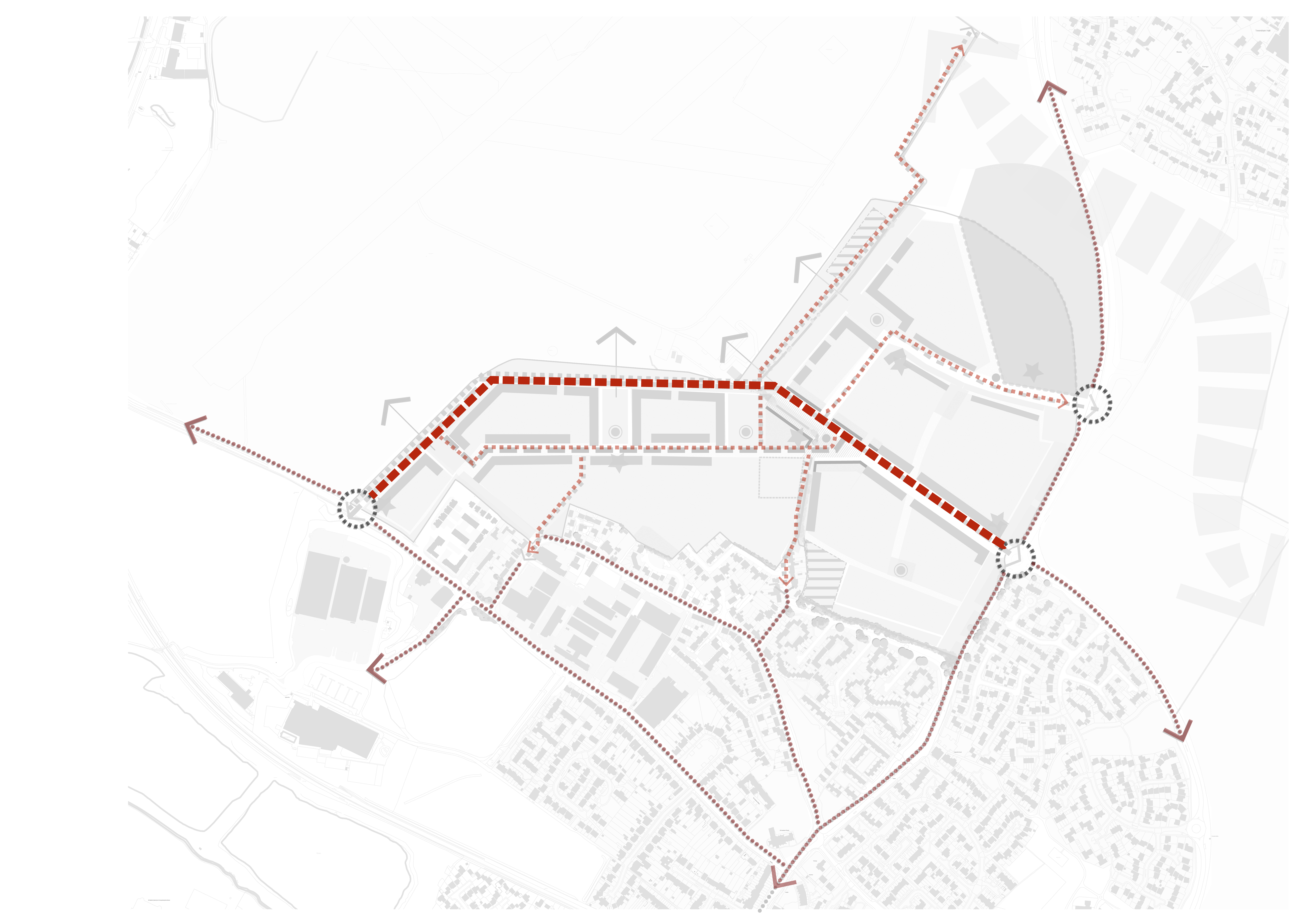
Figure 42: Primary street options B
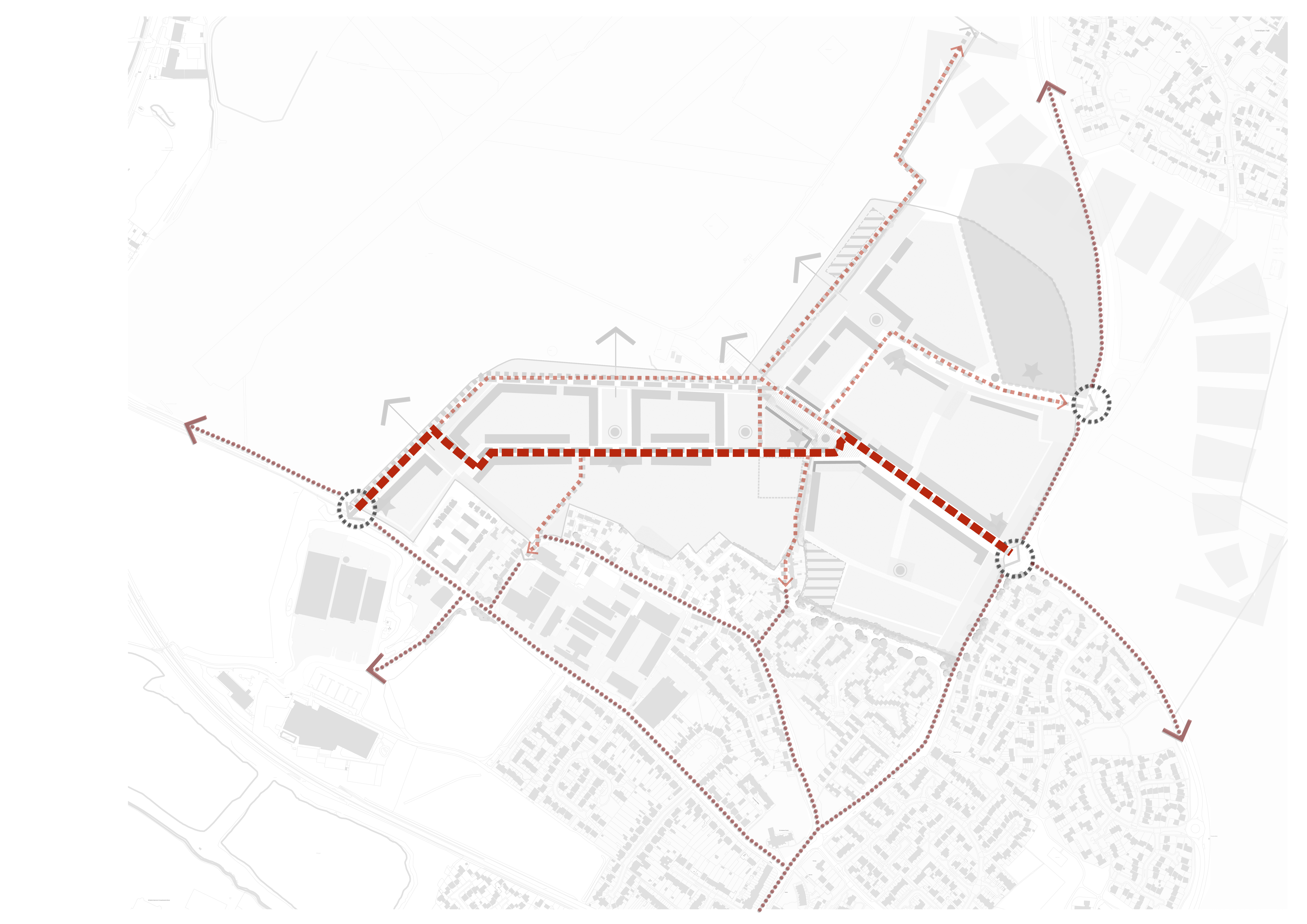
- Places the primary vehicular movement through the centre of the development
- Allows traffic free landscape edge and cycle pedestrian movement along the airport edge
- Opportunity to integrate the new gas main along the
footpaths and verges, keeping landscaped areas and parks free
from constraint
- Requires careful considerations of density and building heights along the primary street due to proximity to the existing residential edge
Cycle and pedestrian movement - potential links
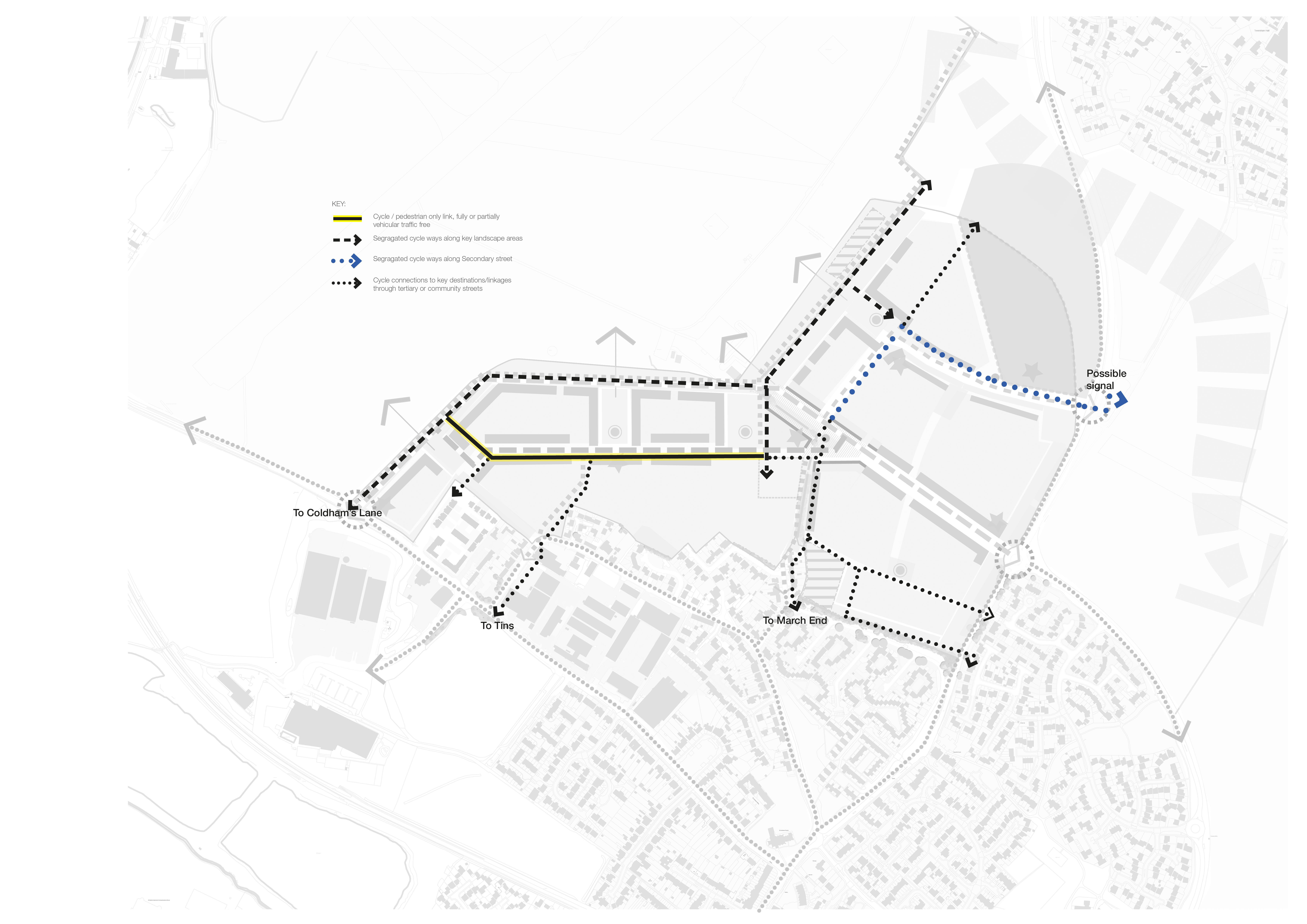
(6) Proposals for the site should be as permeable for cyclists and pedestrians as possible, exploring potential connections to the wider strategic cycle networks surrounding the site such as the Chisholm Trail and the existing Airport path as well as connections on foot to local facilities. Proposals will be required to demonstrate an appropriate walking and cycling strategy in terms of the site, and acknowledge the wider walking and cycling journeys which interface with it.
On-site, direct routes should be provided between areas of housing and community facilities. Local cycle and pedestrian only connections will be encouraged on the site. Pedestrian and cycle connections will also be accommodated on primary and secondary routes. Proposals should incorporate openings and cut through's for cyclists and pedestrians where possible.
Cycle routes should be well integrated into the proposals and utilise the green corridors and low order less trafficked streets. Off road cycle links within the site that are shared by cyclists and pedestrians should be at least 3.5m wide.

Proposals should make full provision of the existing public right of way running south-north through the site, connecting Cherry Hinton to Teversham.
(2) Pedestrian and cycle connections should be delivered by the proposals to facilitate both local and more strategic movements between the site, existing communities and key local services.
(2) In response to consultation feedback, safe cycle and pedestrian linkages through the development with minimum interaction with vehicular traffic should be encouraged.

(2) There is the opportunity to provide a dedicated cycle and pedestrian route through the site. Based on the two options for the primary street route, this dedicated network could come forward as shown in figure 45. Guidance contained with Making Space for Cycling 2014 should be followed when developing proposals for the cycle route.
Options for the primary street include:
- A wholly segregated cycle route is available on the northern boundary of the site for cyclists, providing a completely segregated route between Airport Way and Coldham's Lane.
- There is also a central spine within the development which will be a pedestrian / cycle priority link, with limited or no access for vehicles. The design and arrangement of the blocks around this central spine seek to reduce the volumes of turning traffic potentially conflicting with cyclists.
- External pedestrian and cycle connections are also provided from this central spine through the site to the south, linking with the Tins route and to the east to Cherry Hinton High Street, including access to the existing bus stop which is served by the Citi 1.
(3) Any strategy for public transport must be led by the County Council, in partnership with the local authorities, bus companies and developers. The proposed public transport strategy for the site will build upon the existing network.
(1) Proposals will provide well-connected, high quality pedestrian and cycle routes that connect with the public transport network to help make sustainable travel modes more attractive than use of the private car. The majority of the development should aim to be no more than a 5 minute or 400m walk to bus stops. Figure 46 illustrates how the bus route could come forward.
(1) Any planning application will be accompanied by a public transport strategy, setting out how the site will be served by public transport. Consideration should be given to the restricted height of Coldham's Lane Bridge.
(3) Proposals should accord with Cambridge City Council's parking standards, which are expressed as maximum standards in line with national guidance and the council's sustainability aims, and with CEAAP policy CE/11 (alternative modes and parking), CLP policy 82 (parking management) and SCLP policy T1/3 (parking provision), which seek to ensure appropriate parking provision for new developments for motor vehicles and cycles.
(1) Car parking should be designed to minimise impact on the urban form. The majority of car parking spaces should be provided 'on plot' with parking courts avoided.
(1) Facilities for electric charge points should be incorporated into design proposals with consideration given for provision of EV charge points (In line with Policy 35 of the National Planning Policy Framework (NPPF)).
Safe and secure cycle parking should be provided and should accord with both Cambridge City Council and South Cambs District Council's policy requirements and cycle parking guidelines, following guidance contained with the Cambridge Cycle Parking Guide for New Residential Developments, February 2010. Cycle parking should be considered early in the design process with an emphasis on Sheffield stands or within garages where appropriate.
Environmental considerations & Site-wide sustainability
(1) The development plan policies of relevance are CEAAP policy CE/25 (sustainable building and materials), CE/26 (noise), CE/27 (air quality), CE/28 (an exemplar in sustainability), CLP policy 27 (carbon reduction, community energy networks, sustainable design and construction), policy 33 (contaminated land), policy 34 (light pollution control), policy 35 (protection from noise and vibration), policy 36 (air quality, odour and dust), and SCLP policy CC/1 mitigation and adaption to climate change), CC/4 (sustainable design and construction), and CC/6 (construction methods).
Creating a sustainable development should be a priority underpinning the development of the Land North of Cherry Hinton. An integrated and site-wide approach should be employed to address the environmental, social and economic principles of sustainable design and construction. Development should seek to comply with all essential design considerations set out in the Sustainable Design and Construction SPD (June 2007), or as superseded, and should be strongly encouraged to adopt the recommended design considerations where appropriate.
(1) As the site is within an area of water stress, a key priority for development is to promote water efficiency and water-sensitive design. All dwellings should seek to limit internal potable water consumption to 110 litres/person/day through measures such as low- / dual-flush toilets, using flow restrictors on basin taps, smaller capacity baths and low-flow showers. Opportunities for incorporating rainwater harvesting systems for irrigation purposes, as well as greywater recycling systems, should also be explored.
Promoters of development should prepare a Sustainability Statement that proposes strategies for addressing the relevant sustainability criteria including water conservation, urban design, biodiversity, pollution and sustainable drainage.
Energy, carbon reduction and adaption to climate change
(2) Development should be designed and built in accordance with the energy hierarchy of:
1. Reducing energy demand in the first instance through careful consideration of site layout and by adopting a "fabric-first" approach to building design;
2. Using energy efficiently by, for example, using highly efficient systems to provide space heating and hot water and, where appropriate, heat recovery technologies; and
3. Only then supplying clean, renewable and low carbon energy
to seek to meet the council's 10% on-site energy target,
where it is appropriate to do so. Where renewable and
low carbon technologies are proposed, applicants should
demonstrate that potential adverse impacts on the environment
will be reduced as far as possible.
Development should demonstrate how adaptability will be built in so that future building occupants, particularly the vulnerable, are not exposed to unnecessary risks associated with the East of England's changing climate. Proposals should consider options to reduce potential overheating and reliance on air condition systems in accordance with the following cooling hierarchy of:
1. Reducing internal heat generation through energy-efficient design;
2. Reducing the amount of heat entering a building in summer through measures such as orientation, shading, albedo, fenestration, insulation and, where appropriate, green roofs and walls;
3. Managing heat within the building, e.g. through use of thermal mass and consideration of window sizes;
4. Passive ventilation;
5. Mechanical ventilation;
6. Only then considering cooling systems (using low carbon options).
Planning applications should be supported by an Energy Statement outlining the proposed strategy for conforming with the energy and cooling hierarchies outlined above.
Air quality should be
considered at the design stage, with consideration given to
mitigating emissions ant the site wide level. Development
should comply with best practice guidance set out in the IAQM
Land Use Planning & Development Control: Planning for
Air Quality (2017), or as superseded. Consideration should be
given to the following (please note the below list is not
exhaustive):
- Combustion Emissions - Consideration should be given at an early stage to the method of energy provision in the context of its impact on air quality including location of combustion emissions away from receptors through well cited vents or chimney stacks; scale of delivery e.g. district heating or CHP; height of chimney stacks in relation to dispersion and corresponding design constraints
- Incorporate facilities for electric charge points - Consideration should be given for provision of EV charge points across all appropriate land uses.
- Design should ensure there are no 'street canyons' which could inhibit effective pollution dispersion and lead to future air quality problems.
The relevant policies are CEEAP policy CE/24 (energy), CLP policy 29 (renewable and low carbon generation), and SCLP policy CC/2 (renewable and low carbon energy), and CC/3 (renewable and low carbon energy in new developments).
The development at LNCH will be designed and built in accordance with the energy hierarchy of reducing energy demand in the first instance (Be Lean), using energy efficiently (Be Clean) and, only then, supplying clean renewable and low carbon energy, where it is appropriate to do so (Be Green). The energy hierarchy is illustrated in figure 47.
Any planning application(s) for development will be supported by an Energy Statement presenting passive energy demand reduction measures adopted in the masterplan, options for further reducing demand through building designs, and options for efficiently supplying heating and cooling to buildings. The Statement(s) will include a preliminary feasibility study identifying opportunities for incorporating building-integrated or standalone renewable and low carbon technologies and, where appropriate, opportunities for 'exemplar' energy efficiency projects and consideration of smart grid approaches.

Surface water drainage strategy
The development plan policies of relevance are CLP policy 31 (integrated water management and water cycle), policy 32 (flood risk), and SCLP policy CC/7 (water quality), CC/8 (sustainable drainage systems), and CC/9 (managing flood risk). In addition the emerging flood risk and drainage design will follow best practice and planning regulations, including the Cambridge Flood and Water Supplementary Planning Document (SPD) 2016 which aims to guide the approach taken to manage flood risk and the water environment as part of new development proposals. Sustainable drainage must be considered early in the planning process in order to integrate it into the design.
Flood Risk and existing watercourses
(1) The Environment Agency's (EA) flood risk maps show the site as low risk for fluvial flooding, but with some areas as potentially at risk of flooding from surface water. Fluvial flooding is typically defined as flooding caused by water in rivers rising above bank levels, while surface water flooding is flooding caused by heavy rainfall running off land and ponding in areas of low topography, as it flows towards a watercourse or land drain. In reality, flooding is often caused by both sources of flood water combining together.
Modelling of the current surface water flood risk illustrated at the site is currently being undertaken to provide more confidence in the flood extents and to inform the site layout and master planning process. This follows the planning principles of making space for water and placing the most vulnerable land uses in areas of lowest flood risk. Flood compensatory works are proposed at the site to allow for areas currently shown within the surface water flood risk extent to be incorporated within the emerging masterplan. The form of the flood compensation areas will be designed in agreement with the approving authorities and ensure there is no detriment to offsite areas. These areas will be visually in keeping with the current landscape.
Sustainable surface water drainage strategy
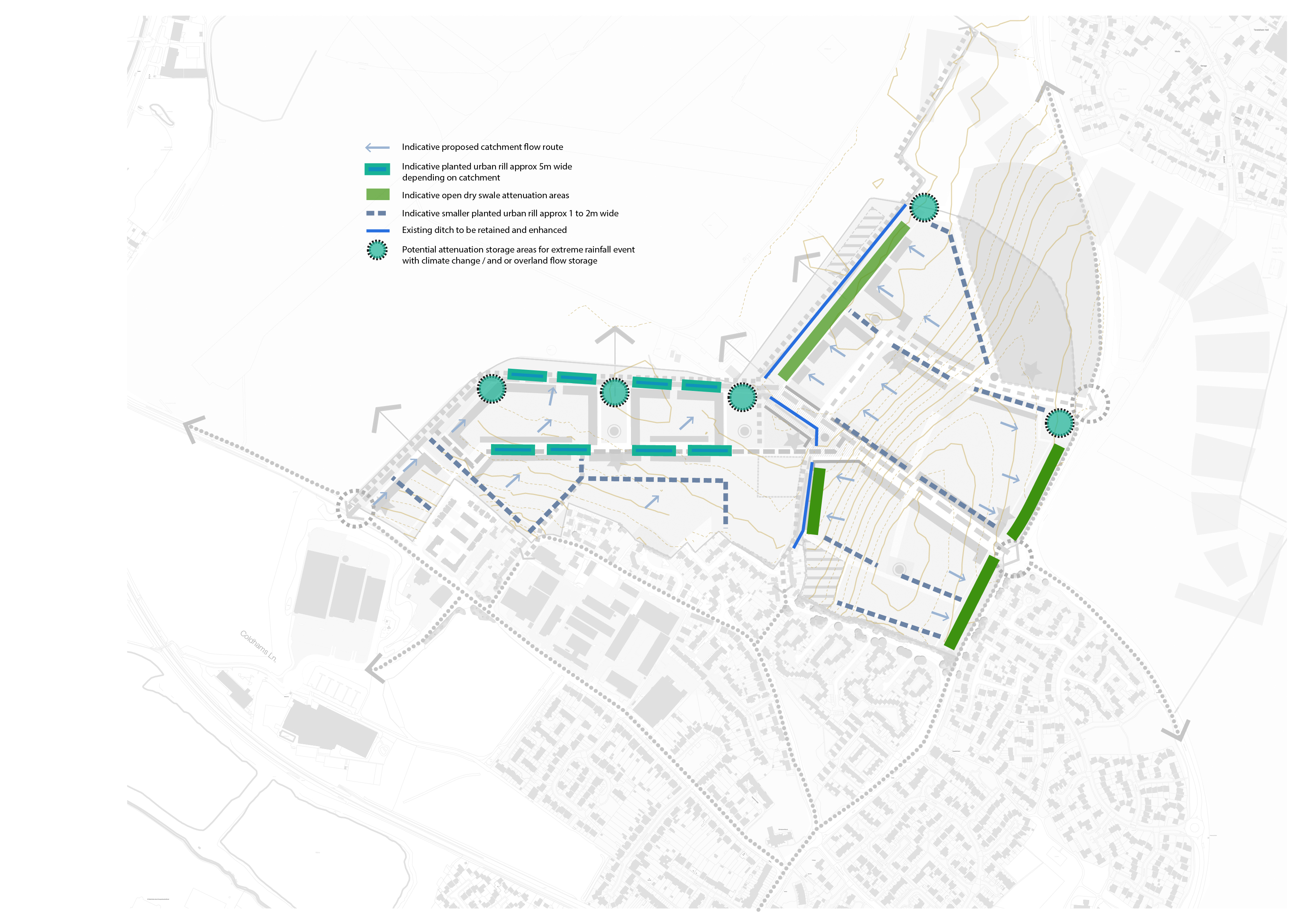
(2) The proposed surface water drainage strategy for the site is being developed and informed by the existing site constraints and hydrological catchments. The surface water drainage will be carefully developed to address the proposed landscape and visual requirements, identified during the baseline analysis for the project. Sustainable drainage will be considered at the outset of the outline planning application process in order to fully integrate the proposed Sustainable drainage into the development proposals.
The proposed development will include a comprehensive Sustainable Drainage System (SuDS), which will play an integral part of the green infrastructure (GI) for the project. The proposed SuDS seeks to deliver long term mitigation by attenuating and treating the development generated surface water runoff and where possible provide betterment. The SuDS will be designed so it will integrate within the wider landscape proposals and will provide opportunities, where possible, to enhance biodiversity and recreation facilities.
As well as providing a drainage function, the SuDS will also form an important part of the project's biodiversity strategy. The proposed SuDS features will be designed so that they maximise opportunities for habitat creation and wildlife. This will include the introduction of appropriate native planting.
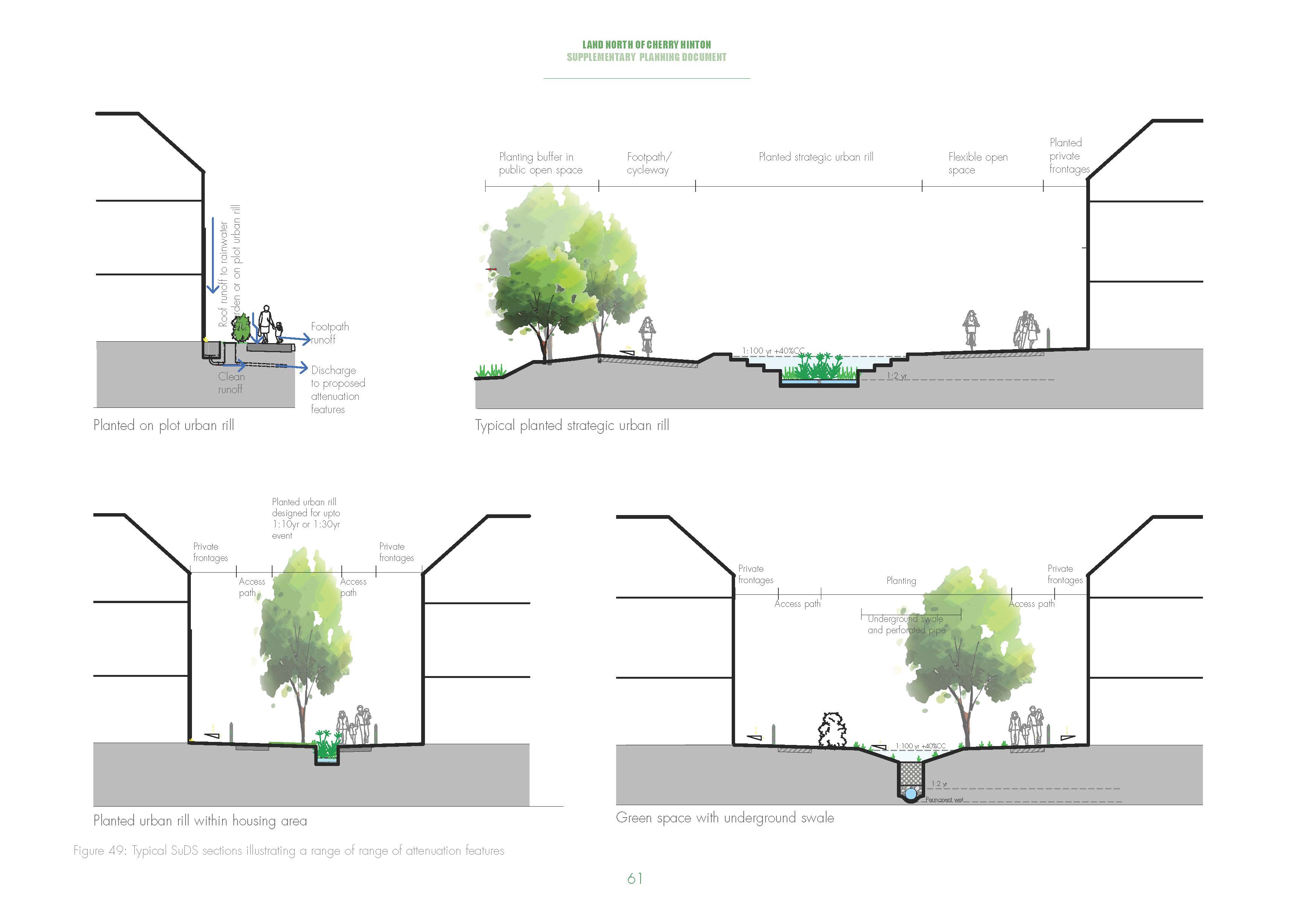
The prevailing surface water strategy to be adopted is a network of on-site planted and unplanted channels and urban rills which will provide attenuation and water quality treatment. Other strategic attenuation areas will also be required, including features such as linear dry swales and landscaped detention areas, providing dual use facilities such as play areas / recreational space in order to provide the necessary storage for extreme rainfall events and overland flow storage. Upstream on plot drainage solutions such as bio-retention planters and permeable paving will also provide pre-treatment for hard standing surfaces such a parking areas. Roof runoff, where feasible, will outfall directly into smaller on plot urban rill arrangements, bio-retention planters, porous paving or rainwater gardens. Piped networks will still be appropriate in some areas of the site due to the gradients which prevent the use of open channels and rills. The incorporation of large permanent open water features, attractive to wildfowl, will be discouraged in order to avoid the risk of bird strike. It should also be noted that proposals for below ground attenuation will be considered as a last resort.
Due to the site's close proximity to Cambridge Airport, the SuDS will need to be designed to take into account the risks from bird strike. Therefore, ongoing discussions are being undertaken with the aviation authorities to ensure the proposed SuDS is designed in accordance with best practice.
High groundwater levels and some isolated areas of soil contamination (subject to confirmation) may potentially exist in parts of the site, this will need to be considered and any results used to inform the emerging drainage strategy.
(2) Foul water drainage will discharge from the development to a local foul public sewer. This will be subject to agreed discharge rates with Anglian Water and is likely to require the presence of pumping station/s within the proposed development. Previous discussions with Anglian Water, as part of the pre-application process, indicates foul storage will be required. The storage can either be provided within the site boundary or at a local pumping station. Ongoing consultation with Anglian Water will be undertaken to ensure the development proposal meets their requirements.
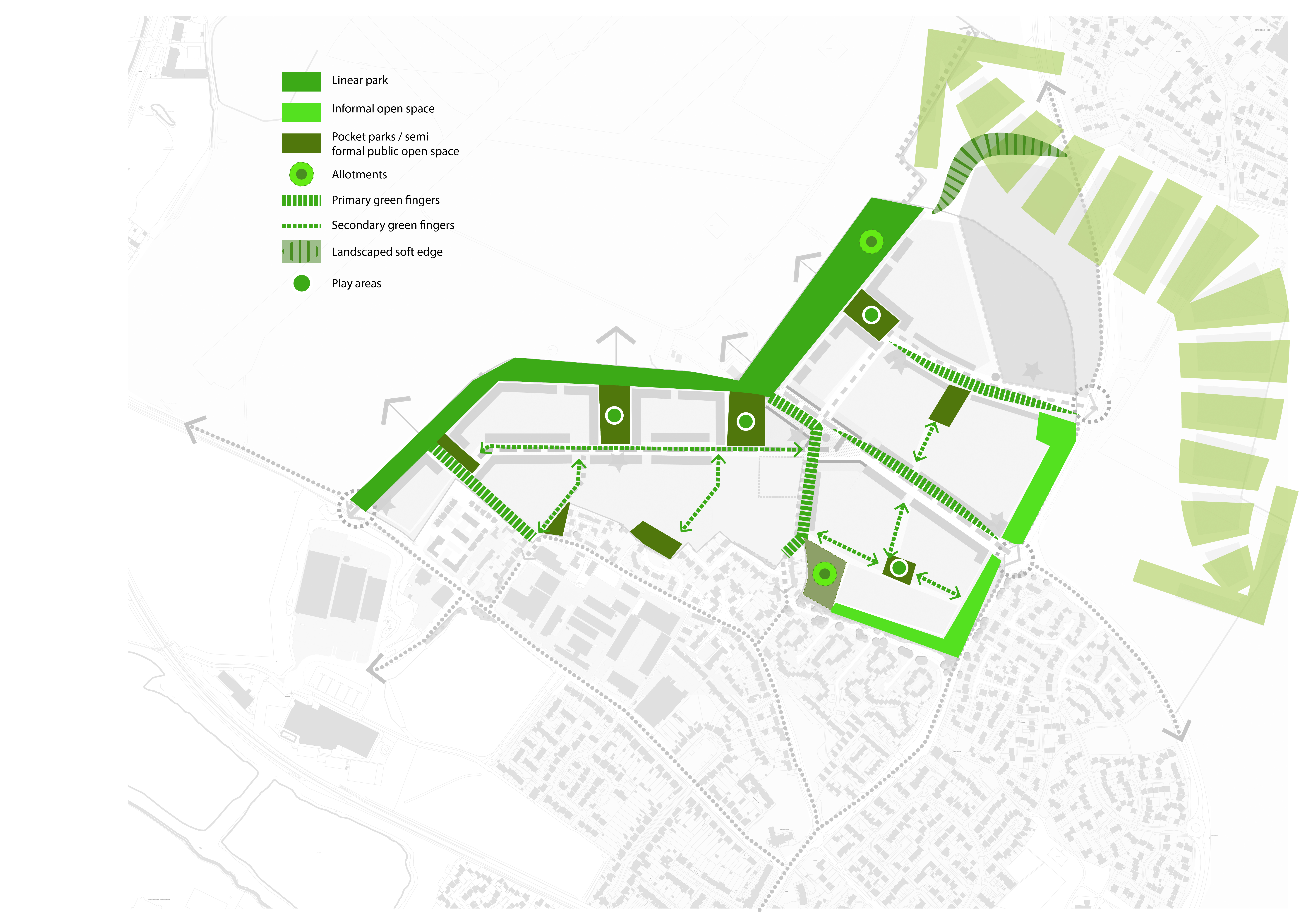
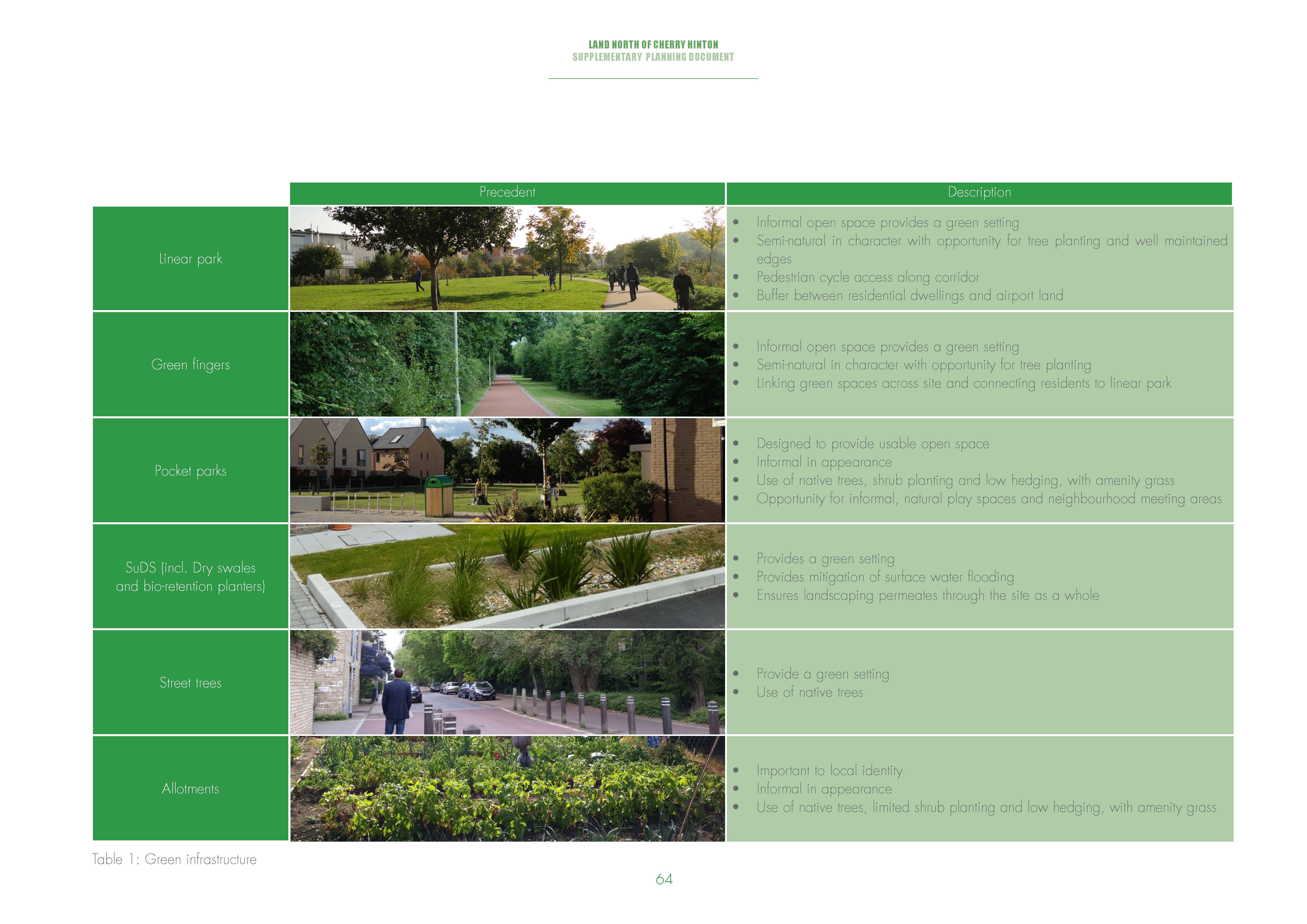
(2) The development of the site provides the opportunity to create an attractive green framework of public open spaces and wildlife habitats and to encourage sustainable lifestyles. The landscape strategy should be built around the existing landscape and will provide greenways, formal and natural play, pocket parks and allotments in line with policy requirements.
This section considers the following:
- Open spaces and recreation
- Trees
- Ecology
The relevant policies in the emerging development plans are CEAAP policy CE/20 (public open space and sports provision), CE/21 (countryside recreation), CLP policy 55 (responding to context), policy 56 (creating successful places), policy 59 (designing landscape and the public realm), policy 68 (open space and recreation provision through new development), SCLP policy HQ/1 (design principles), policy NH/2 (protecting and enhancing landscape character), policy NH/6 (green infrastructure), NH.7policy NH/8 (mitigating the impact of development in and adjoining the green belt), policy NH/12 (local green space), and policy SC/7 (outdoor play space, informal open space and new developments), SC/8 (open space standards).
(1) Development should seek to ensure an optimum distribution of open space so that all residents enjoy proximity and easy access to open space without having to overcome barriers to movement, such as major roads. Figure 50 and table 1 illustrate how open space could be provided across the site.
(1) The accessibility of open spaces and play areas will have a direct impact on their functional success. More accessible spaces usually tend to attract a greater level and range of activities, thereby increasing levels of natural surveillance that can help deter anti-social behaviour and potentially reduce the need for repair.
A mix of spaces will be
required to meet recreation needs. A balanced approach will
be required to resolve potential conflicting demands, for
example demands between natural, tranquil spaces and those
for children's play. Open spaces should be connected through
the incorporation of street trees and SuDS features.
Public
realm
(3) The development framework plan establishes a series of key nodal public spaces along the main routes. These are important to provide a strong sense of place. Principal among these will be the local centre, which is intended to be a busy public space where the community congregate. This square should be designed based on a shared space philosophy and be of the highest quality.
Open space and recreation
The relevant planning policies are CEEAP policy CE/20 (public open space and sports provision), CLP policy 68 (open space and recreation provision through new development), SCLP SC/7 (outdoor play space, informal open space and new developments), and SC/8 (open space standards).
The integration of semi-natural habitats within new developments lies at the heart of much current thinking on urban nature conservation. The extension of this concept to form wildlife corridors, green grids or networks has added benefits where these include public open spaces and green routes providing alternative green recreational routes for pedestrians and cyclists.
(3) Development of the site will include a green corridor and series of smaller linked green spaces, comprising an informal linear park, play space and allotments. As well as reinforcing the city-wide green network, connected open spaces can play an important part in helping to integrate new development into the existing area. Green spaces will be linked by street trees and SuDS features.
(3) Development of the site should ensure that an adequate level and mix of recreation space is provided to serve the new community. This provision should be of a high and durable quality, designed to ensure they are accessible, well-connected and integrated with new and existing communities. They should also encourage healthy lifestyles and the use of sustainable travel modes, such as cycling.
Table 2 outlines the public open space (POS) requirements based on the emerging policy position as set out in Cambridge City Council Proposed Submission July 2014 (Policy 68 requires open space provision as per table l.1 Open space and recreation standards from Appendix 1).
This table sets out the requirements, resultant land take, based on 1200 units, using the agreed population multipliers. Incidental green spaces such as verges, tree lined road corridors and other green spaces are not included within the calculations.
It must be demonstrated through the detailed design that open space located adjacent to the primary street is of a high quality.
|
Type |
Policy standard hectares (ha) per 1000 population |
Multiplier |
|
2.3/1000 |
||
|
Informal Open Space |
2.2 |
6.07 ha |
|
Allotments |
0.4 |
1.10 ha |
|
Outdoor sports facilities |
1.2 |
3.31 ha |
|
Indoor sports facilities |
1 sports hall per 13,000 people, 1 swimming pool per 50,000 |
N/A |
|
Children and teenagers play space |
0.3 |
0.83 ha |
|
Total |
4.1 |
11.30 ha |
Table 2: Open space provision requirements
(2) Provision may be made for formal sports pitches in part through community access to pitches and facilities at the secondary school, and / or via improvements to existing facilities in Cherry Hinton. Final provision of sports pitches should be decided in consultation with the relevant stakeholders and will be secured through the planning application process.
The full benefits and requirements of open space and recreation are documented in further guidance published by the city council in 2014, including Open Space and Recreation Strategy, Parks for Cambridge People and Cambridge Sports Strategy.
Play space and sports provision
(2) Children's play space for a range of ages should be provided within the development. It is estimated that approximately 0.8ha of equipped play space / outdoor provision would be required on site. It is anticipated that this will comprise a minimum of two local equipped areas of play (LEAP) and one neighbourhood equipped area of play (NEAP). Local areas for play (LAPs) will be dealt with at a later stage as part of the outline planning application.
(3) Some informal open space should be provided within the new built-up areas, for example, green access corridors, informal kick-about areas and small buffer areas adjacent to equipped areas of play. The majority of provision is likely to be located along the green corridor, which should include approximately 6ha of natural green space.
(1) Allotments should be provided in close proximity to overlooking homes and be accessible for new and existing residents. The likely requirement for the provision of allotments across the site is approximately 1.1ha, although the exact extent will be determined as part of the outline planning application.
(1)
Existing trees are an
important factor on development sites and a material
consideration in the UK planning system. There are a number
of trees on the site alongside the PRoW. These should be
retained and incorporated into landscape proposals where
possible.
Trees play an important role in the public realm and in enhancing existing landscape features. Street trees should be planted along streets and within public open spaces. Species should be selected to establish a sense of hierarchy through the streets and spaces, with larger trees on key routes and spaces.
Three non-statutory designated ecological sites are present on the site boundaries:
- Airport Way RSV County Wildlife Site (CWS) is located along the eastern boundary. The CWS includes the road verges and associated hedgerows/scrub on Airport way. It is of interest for its population of perennial flax, a nationally scarce plant
- Teversham Drift Hedgerow City Wildlife Site (CiWS) forms part of the south boundary
- Teversham Protected Road Verge (PRV) forms part of the east boundary. The PRV includes the road verges and associated hedgerows/scrub on Airport Way and Cherry Hinton Road. It is of interest for the quality of the grassland habitat present in the road verge.
(3) Design measures to minimise impacts of the development on these features are as follows:
- Retention and protection of hedgerows during construction where possible; planting of additional hedgerow using a diverse species mix to achieve net enhancement of this habitat resource
- Retention and protection of non-statutory designated
sites on the boundaries of the site during construction
through the use of buffer zones and the provision of adjacent
public open space. Creation of species-rich grassland
to achieve net enhancement of this habitat resource
- Retention of drainage ditches with a buffer to avoid impacts on water vole and enhancement of water vole habitat (creation of pools and re-profiling of drainage ditches, and provision of SUDs features)
- Retention and enhancement of habitat features, such as hedgerows and ditches, suitable for bats. Using a lighting scheme which avoids illumination of these retained habitat features. The incorporation of bat roosting features in buildings within the proposed development.
Housing
The relevant policies in the development plan are CEAAP policy CE/7 (Cambridge East housing), CLP policy 45 (affordable housing and dwelling mix), policy 50 (residential space standards), policy 51 (lifetime homes and lifetime neighbourhoods), SCLP H/7 (housing density), policy H/8 (housing mix), policy H/9 (affordable housing), and H/11 (residential spaces standards for market housing).
In line with the allocation, the primary land use will be residential housing. LNCH has capacity for up to 1,200 homes during the local plan period to 2031.
(1) Based on initial capacity studies the 1,200 residential units are likely to comprises a mix of 35% apartments and 65% houses, although the exact mix is flexible and will be informed by consideration of the housing market dynamics and evolving urban character.
(1) The average overall net housing density proposed for the site will be 40-50 dwellings per hectare (dph). Lower densities will be located on the southern edge of the site adjacent to the existing settlement, with density increasing northwards. The higher densities will be focussed around the local centre and main activity zone.
(3) The site is suitable for a range of housing typologies. A wide choice, type and mix of housing will be provided to meet the needs of different groups in the community, including families with children, older people and people with disabilities. This will assist the creation of a sustainable, mixed community within the site. The site may provide specific homes for the elderly depending on market demand.
(2) The affordable housing policies require a minimum of 40% to be delivered on the site. Developments should include a mix of dwelling sizes, types and tenures to meet projected future household needs within Cambridge. The development will be tenure blind with the affordable homes integrated with market housing and not identified through location, segregation or the appearance of buildings.
(1) Dwellings will be designed to provide future occupiers with efficient internal layouts, room sizes and access to the private amenity space. Dwellings will aim to provide adaptability and flexibility.
The relevant policies are CEAAP CE/9 (community services), CLP policy 74 (education facilities), and SCLP policy SC/4 (meeting community needs).
(5) The site allocation requires provision of a primary school and secondary school. The primary school should be located within close proximity of other community facilities. The secondary school should be located close to the edge of the development and within relation to key transport routes.
(4) In respect of the new primary school, provision should be made for a 2 form entry (FE) primary school and 2.3 hectares to serve the needs of the community.
(3) To ensure the secondary school is educationally and financially viable and to serve the wider needs of Cambridge, it will need to be a minimum of 6 FE. The final site size will be determined through further detailed planning and negotiation.
The preferred locations for the primary and secondary schools are shown indicatively on figure 31. The design of the school buildings will be expected to perform a positive role within the urban environment.
Community & other non-residential uses
(1) The relevant development plan policies for community uses are CEAAP CE/9 (community services), CLP policy 73 (community, sports and leisure facilities), and SCLP policy SC/4 (meeting community needs).
(4) Community facilities should be centrally located within the development site and within easy reach of all residents of the new community. The facilities should also be accessible for existing residents of Cherry Hinton. It is intended that the development will not compete with the Cherry Hinton High Street offer.
(4) The local centre will reflect the needs of the likely future population whilst supplementing facilities already available within Cherry Hinton and should include a number of small local shops and a nursery, although the final provision of the social infrastructure has to be determined as part of any outline planning application.
The relevant development plan policies are CLP policy 55 (responding to context), policy 56 (creating successful places), policy 57 (designing new buildings), policy 59 (designing the landscape and the public realm) and SCLP HQ/1 (design principles).
(1) The proposals for Land North of Cherry Hinton must create a clear identity that is cognisant of the 'village' character that existing residents of Cherry Hinton cherish. It will ensure placemaking is central to the layout, with the highest quality materials, architecture, landscape and public realm.
(1) Existing features of the site, including the distinctive topography, treed public right of way, historic hedgerow and attractive views across the airport and towards Teversham, should be woven into the layout to create a memorable and attractive new neighbourhood.
(4) The initial vision and design principles outlined in this SPD will build upon and strengthened to establish a compelling narrative for the new neighbourhood with a strong identity.
Figure 51 shows an indicative building heights strategy for the site, setting out the broad principles. The final strategy will be agreed through the outline planning application and informed by further analysis and the local context.
Based on the net residential area (including the local centre) of between 27 and 30 ha, the average overall net housing density proposed for the site will be 40-50 dwellings per hectare (dph). This excludes primary infrastructure such as public open space and the main street, along with non- residential land uses such as the primary and secondary schools. Lower densities will be located on the southern edge of the site adjacent to the existing settlement, with density increasing northwards across the site. The higher densities will be focussed around the local centre and main activity zone.
A range of building and housing types should be provided across the site. This range of typologies will help create an integrated community, with homes suitable for a range of household types and sizes. Careful consideration should be given the landscape and visual impact of building heights across the site.
New homes should maximise the benefit of solar orientation and outlook, whilst providing a robust street and block layout.
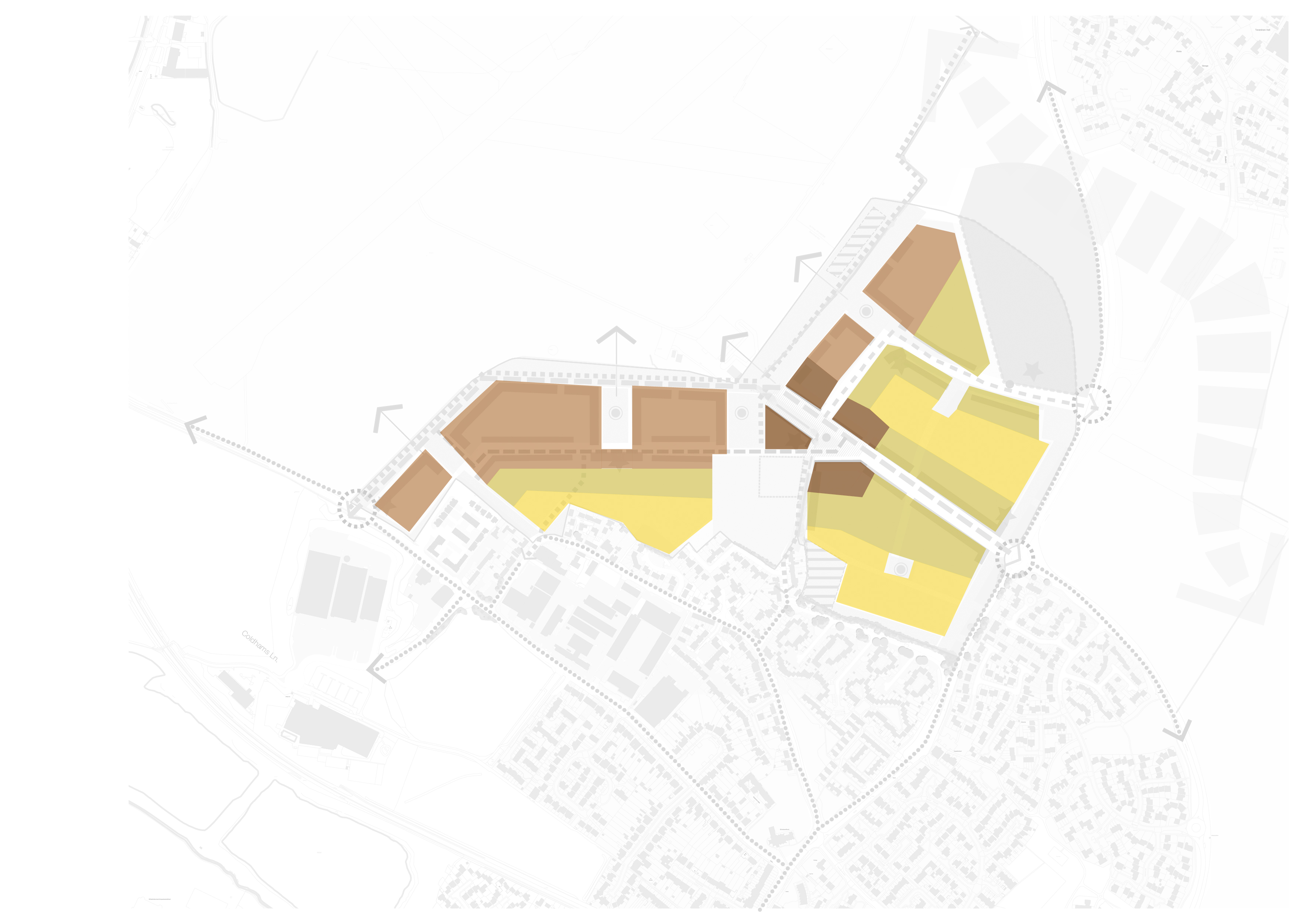
A range of building heights
should be provided across the site and create visual interest
and character. In broad terms, building heights should
increase around the local centre and along key movement
corridors. Building heights should respond to the higher
ridgeline, minimising the impact on long distance views.
Building heights should ensure an appropriate edge to the
green belt and take account of the potential to help mitigate
airport noise.
Streets are to be designed to be safe and legible and must add to the richness of the built environment. For the primary street a number of options are currently shown, and the final configuration will be determined via the outline application. The primary street must be legible and be perceived as the main route through the scheme. Built form and elevational treatment should reflect its primary role, with a high proportion of the 3-4 storey dwellings along this route. The intended design speed limit is 20mph.
(1) The majority of streets will be lower order in character, with reduced traffic speeds to slow traffic and encourage cycle and pedestrian movements.
(1) Tree planting along all streets will be fundamental to establishing a green setting to the housing, reflecting the local character of Cherry Hinton and connecting the green spaces and site with the surrounding area. A high proportion of smaller ornamental flowering trees should be used along lower order streets, with larger trees on primary routes focused within the open space and key public spaces.
The gas main is intended to be realigned along the primary street. The detailed realignment will be subject to further evolution of the master plan principles and consultation with National Grid Gas (NGG).
An appropriate easement for the realigned gas main should be incorporated into design proposals. This may be a negotiated easement of 3m either side of the gas main. An appropriate building proximity distance of 3m either side of the new gas main should also be incorporated in the design proposals, however any building must not impact the maintenance or access to the gas main.
(2) Any proposals to locate a feeder road over the new gas main would need to be agreed with NGG, as would proposals to lay of any future new utility services within the easement.
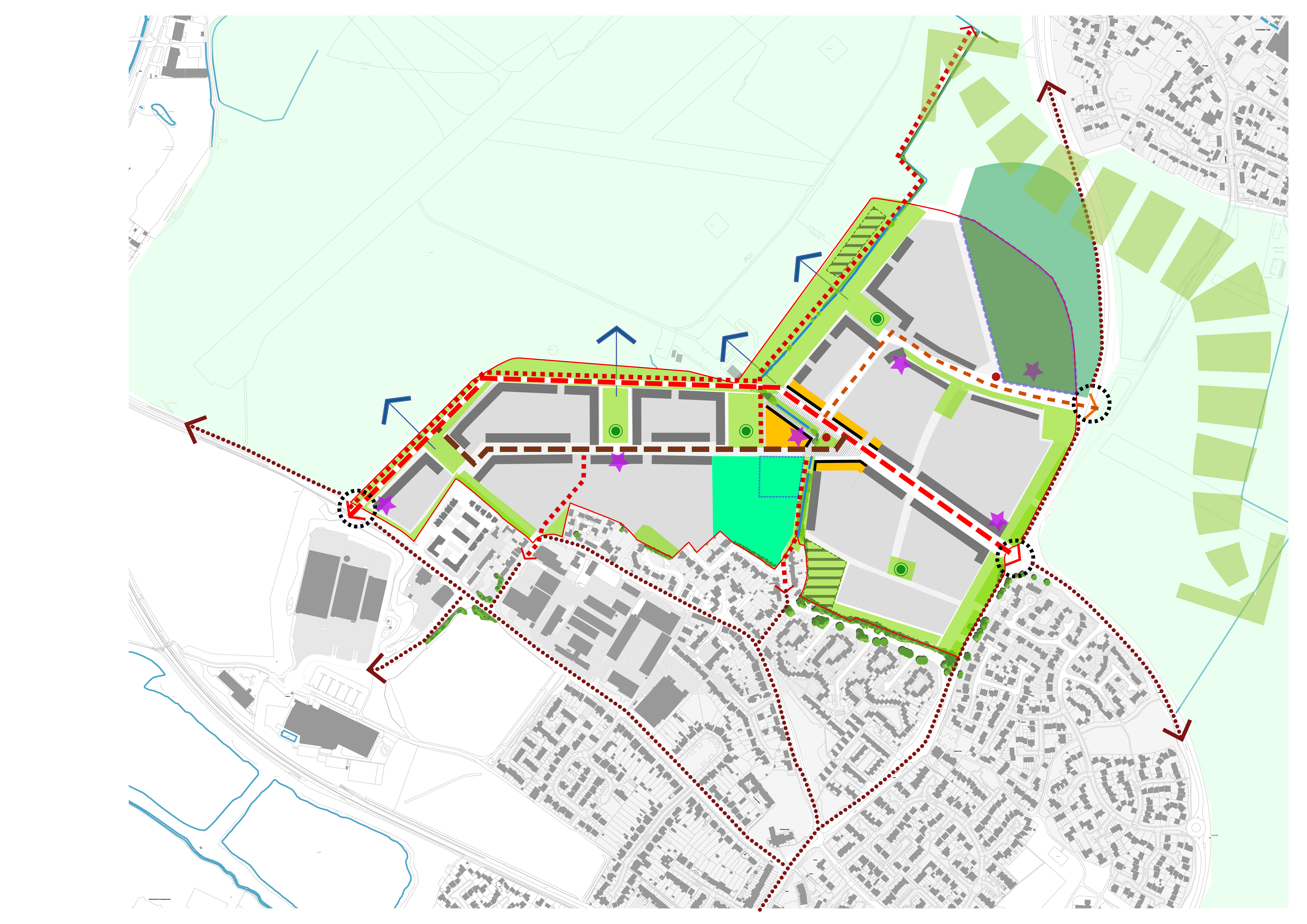
Figure 52 illustrates the key development principles. The plan establishes a robust framework for development of LNCH. Figure 52 is shown for indicative purposes only, with the final layout to be agreed through the outline planning application.
(1) Constraints and challenges
- Mitigating significant additional traffic congestion in the immediate locality
- Noise intrusion from airport and Cherry Hinton Road
- Gas main crossing the site could compromise the layout unless diverted
- Protecting existing habitats of value
- Mitigating surface water flooding
- Providing safe pedestrian and cycle connections to existing facilities
- Retaining distinct 'village' character of Cherry Hinton
- Maintaining soft green edge to Teversham
(2) Opportunities
- Create an attractive new urban edge and memorable gateway to Cherry Hinton
- Improve cycle and pedestrian connections between Cherry Hinton and Teversham
- Integrate with the existing village and support local facilities
- Celebrate views across the airport
- Built form should positively respond to the distinct topography of the Site
- Create new civic square in central location
- Secondary school to serve wider community and aid integration
- Provide a new dedicated cycle/pedestrian link between Cherry Hinton Road and Coldhams Lane
- Use of the existing water course as a basis of a SuDS system to mitigate surface water flooding
- and as a basis for green corridors through the
development
(2) Key development principles
- Provide safe and direct cycle routes between the settlements of Cherry Hinton and Teversham and between Coldhams Lane and Cherry Hinton Road
- A new, centrally located civic centre with local shops, community hall and primary school
- Incorporate a bus loop from Airport Way that passes through the local centre
- Celebrate views across the airport by designed vistas along greenways
- Play provision within the primary and secondary school should be available for community use outside of school hours
- Establish a strong green framework that includes greenways, formal and natural play, pocket parks and allotments
- Promote of low carbon principles and the integrate SuDS into the landscape
- Establish a linear nature park along the airport edge incorporating the existing countryside walk along the existing public footpath
- Create a clear hierarchy of streets which are attractive
and safe routes for pedestrians and cyclists.
Planning obligations
(2) This section provides a general overview on the planning obligations framework and requirements for the development. At the time of finalising this SPD for public consultation purposes, the joint Cambridge City Council/ South Cambridgeshire District Council Local Plan process is ongoing, aiming for adoption in spring 2018. At present, there is no date scheduled for the Community Infrastructure Levy (CIL) hearing and the programme for this is currently under discussion with the Local Plan Inspector. In addition, the evolution of the outline applications is at a very early stage of development and a number of principles relating to key infrastructure requirements are still under discussion with the district councils, Cambridgeshire County Council and other public service stakeholders. This section therefore provides a starting point for establishing the planning obligations requirements for the development but this will be an iterative process, which will be developed further, as the project progresses. Key documents that will inform the planning obligations requirements in more detail will include the outline planning application Environmental Statement and Transport Assessment; together with any work commissioned /carried out by the local authorities and other public service stakeholders and the outcomes of the public consultation on both the SPD and the outline application in due course. The schedule below is therefore not comprehensive or final but based upon the best information available at the present time.
(3) Given the likely timing of the submission of outline applications, towards the end of 2017, it is likely that this development will be considered under the S106 regime rather than the CIL regime but this will be formally confirmed by the district councils in due course. A particular consideration will be the extent of key on-site infrastructure such as the primary and secondary schools and community facilities which need a high level of certainty in terms of timing of delivery.
Planning Policy Framework
- CIL Regulations 2010 – introduced the three statutory tests against with which all planning obligations requirements must be compliant namely: necessary to make the development acceptable in planning terms; directly related to the development; fairly and reasonably related in scale and kind to the development.
- National Planning Policy Framework (NPPF) 2012
- Joint Cambridge East Area Action Plan (CEAAP) Adopted February 2008
- Cambridge Local Plan 2006
- SCDC Core Strategy 2007
- SCDC DC Policies DPD 2007
- Emerging Cambridge Local Plan 2014
- Emerging SCDC Local Plan 2014
- Cambridge City Council Affordable Housing SPD 2008
- Cambridge City Council Planning Obligations SPD 2010
- Cambridge City Council Sustainable Design and Construction SPD 2007
- Cambridgeshire Flood and Water adopted by SCDC in
November 2016/ City Council has yet to formally adopt –has
emerging SPD status 2016.
(4) Other topic-specific SPDs and guidance e.g. Public Art (2010), Open Space and Recreation Strategy 2010.CIL Regulations 2010 –introduced the three statutory tests against with which all planning obligations requirements must be compliant namely: necessary to make the development acceptable in planning terms; directly related to the development; fairly and reasonably related in scale and kind to the development.
Issues such as timing of delivery, triggers and amount of financial contributions where applicable will be considered as the pre-application process moves forward on the outline applications.
|
Category of Infrastructure |
Requirements |
|
Housing |
Affordable Housing –on-site provision of 40% or more subject to viability ; affordable housing tenure split to be agreed in detail but starting point will be the requirements set out in the City Council’s Affordable Housing SPD |
|
Education - secondary |
Land (8ha) for and financial contributions (equivalent to maximum of 2FE) towards provision of 8 FE secondary school. Shared community use encouraged subject to further discussions. School to be delivered in 2 phases. Specification similar to Trumpington Community College |
|
Education - primary |
Land (2.3ha with potential to expand to 3ha) for and financial contributions towards provision of 2 FE primary school with 2no. early years classes (with potential to expand to 3FE) . Shared community use (not playing pitches) encouraged subject to further discussions. Specification similar to Wing primary school |
|
Education - revenue |
Any school revenue support requirements to be confirmed |
|
Library / lifelong learning |
Financial contributions towards improvements /expansion of existing library facilities within the Cherry Hinton area |
|
Transport - strategic road network / capacity improvements |
To be confirmed through Transport Assessment process |
|
Transport –walking, cycling and equestrian |
To be confirmed through Transport Assessment process |
|
Transport –bus service and associated Passenger Transport strategy |
To be confirmed through Transport Assessment process |
|
Transport –travel plans |
To be confirmed through Transport Assessment process |
|
Highways –road junction, crossing and other local improvements |
To be confirmed through Transport Assessment process |
|
Community centre/hall |
Likely to include provision of a community centre/hall on site – further discussions ongoing to confirm requirements |
|
Faith provision |
Will need to be addressed through consideration of community facilities requirements |
|
Primary health care facilities |
Financial contributions towards new GP facilities or improvements to /expansion of existing GP facilities off-site within Cherry Hinton area |
|
Community development workers, youth and project workers, sports development worker |
Financial contributions for an initial fixed period to support the early residential community |
|
Community chest |
Financial contribution to provide start up grants for community projects |
|
Open space –outdoor sports facilities |
Provision for/contributions towards outdoor sports facilities including playing pitches and other outdoor sports facilities; changing facilities. Likely to be a mixture of on-site provision and off-site contributions. There is scope to consider co-location of community sports pitches with the secondary school subject to further discussion. To note CEAAP position that co-located shared grass pitch provision does not count towards the open space standards |
|
Open space –Indoor sports facilities |
Provision for/contributions towards indoor sports facilities including sports hall and swimming –could be a mixture of on-site and off-site provision or contributions to off-site provision within the Cherry Hinton area |
|
Open space –allotments |
On-site provision in accordance with the City Council’s open space standards |
|
Open space- informal open space |
On-site provision in accordance with the City Council’s open space standards |
|
Open space –provision for children and teenagers |
On-site provision in accordance with the City Council’s open space standards |
|
Open space maintenance |
Financial contributions will be sought for a 12 year maintenance period in the event that any open space facilities are agreed to be adopted by Cambridge City Council |
|
Public realm including street trees and associated maintenance |
Site-specific requirements to be identified through the outline pre-application process |
|
Archaeology |
Requirements to be identified through the EIA/outline pre-application process |
|
Ecological mitigation /biodiversity enhancement |
Requirements to be identified through the EIA/outline pre-application application process |
|
Renewable energy |
Strategy to be developed as part of the EIA/ outline pre-application process |
|
Waste –strategic household waste recycling centre |
Financial contributions towards new strategic facilities to be delivered off-site and procured by the County Council |
|
Waste –individual household waste and recycling receptacles |
Financial contributions or direct provision –to be confirmed as part of the outline application pre-application process |
|
Local recycling facility |
Requirements to be identified through the outline pre-application process |
|
Air quality mitigation |
Requirements to be identified through the EIA/outline planning application process |
|
Sustainability (including sustainable drainage ) |
Requirements to be identified through the EIA/outline planning application process. Any bespoke sustainable drainage elements agreed to be adopted by Cambridge City Council will require a 25 year maintenance contribution |
|
Utilities including electricity sub-stations , sewage pumping stations, Super-Fast Broadband installation, provision of sprinklers/fire hydrants |
Requirements to be identified through the outline pre-application process |
|
Public art |
A site-wide public art strategy will need to be submitted as part of the outline application documentation , setting out the principles for public art provision, funding and delivery |
|
S106 monitoring contributions |
Financial contributions to provide for the monitoring of planning obligations |
|
Local construction employment scheme/ apprenticeships |
Requirements to be identified through the EIA/outline pre-application process |
|
Other site specific requirements |
To be identified through the EIA/outline pre-application process |