Mill Road Depot Draft Planning and Development Brief SPD
2 SITE AND CONTEXT
2.1 SITE LOCATION
2.1.1 Mill Road Depot is located off Mill Road, situated to the south-east of Cambridge city centre. It is immediately adjacent to the railway line to the east, and Kingston Street to the west (see figure 5). The site borders Hooper Street to the north and is immediately adjacent to Mill Road east and west local centres.

2.1.2 Figure 6 illustrates a selection of views of the depot site as it currently exists.

2.2 SITE DESCRIPTION
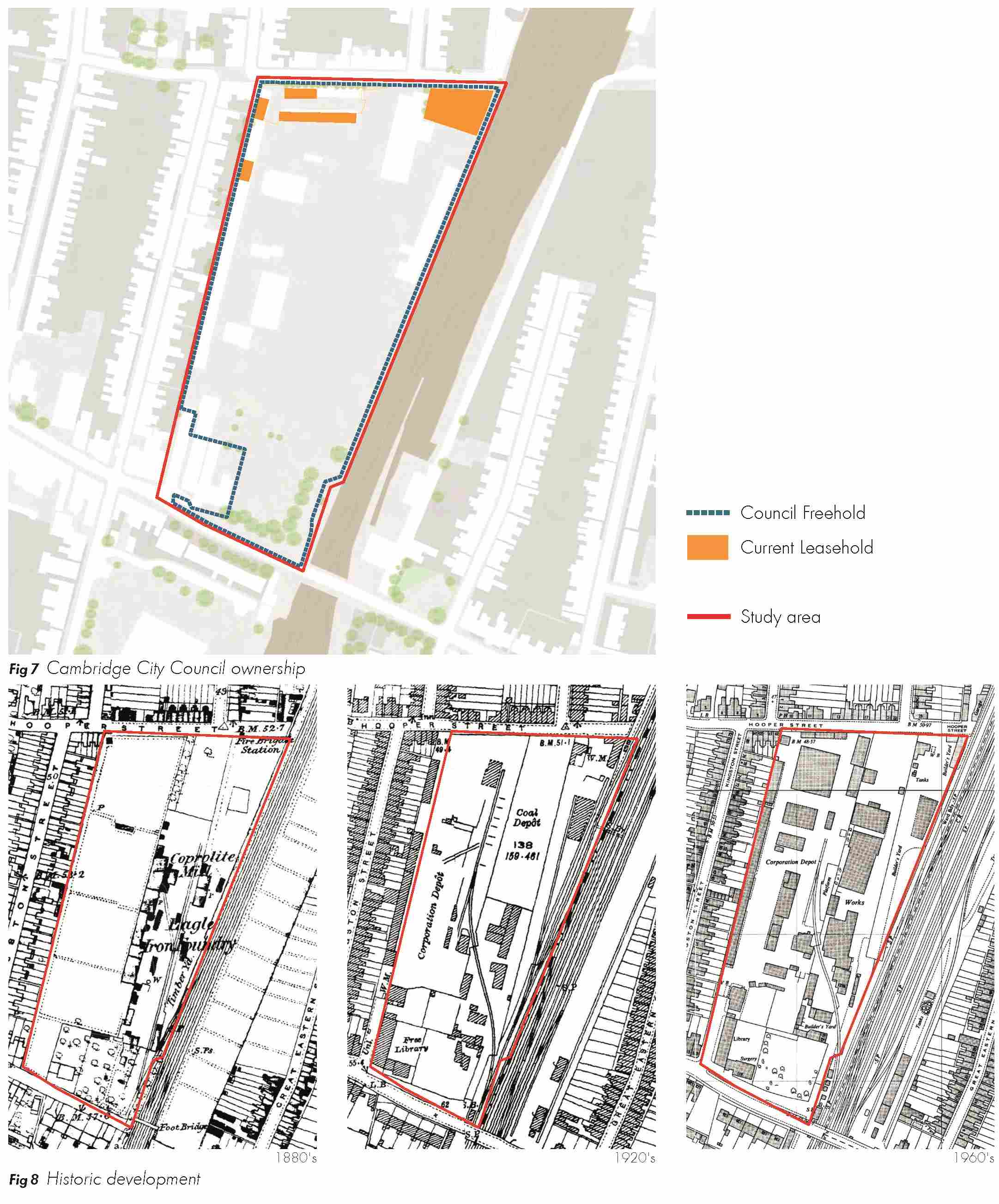
(2) Land ownership
2.2.1 The majority of the site is owned by Cambridge City Council but there are land holdings on the depot site which are occupied by the Regent Language School (see figure 7). Garages to the north-west of the site are the subject of long term leases. A lease ended in 2013 for The Wharf, situated to the north of the site, which is currently occupied by the Women’s Resource Centre. The library building is owned by the County Council.
Click here for Fig 7
(2) Historic development
2.2.2 The site has always been the location of a number of industrial activities (see figure 8). In the 1880s, the site formed a Coprolite Mill, Iron Foundry and Timber Yard. These buildings, located centrally and across the eastern areas of the site, were removed in the 1900s, and a library constructed in the south western corner. The former library has now been converted into a community centre. A Coal Depot was constructed in the 1930s, along with warehouse buildings, which together occupied a large area of the site. The garages to the north-west were constructed in the 1980s. The site became the Council Depot in the 1990s, and more recently, a number of warehouse buildings in the centre of the site were demolished to form a waste segregation area within the depot.
(2) Buildings on site and surroundings
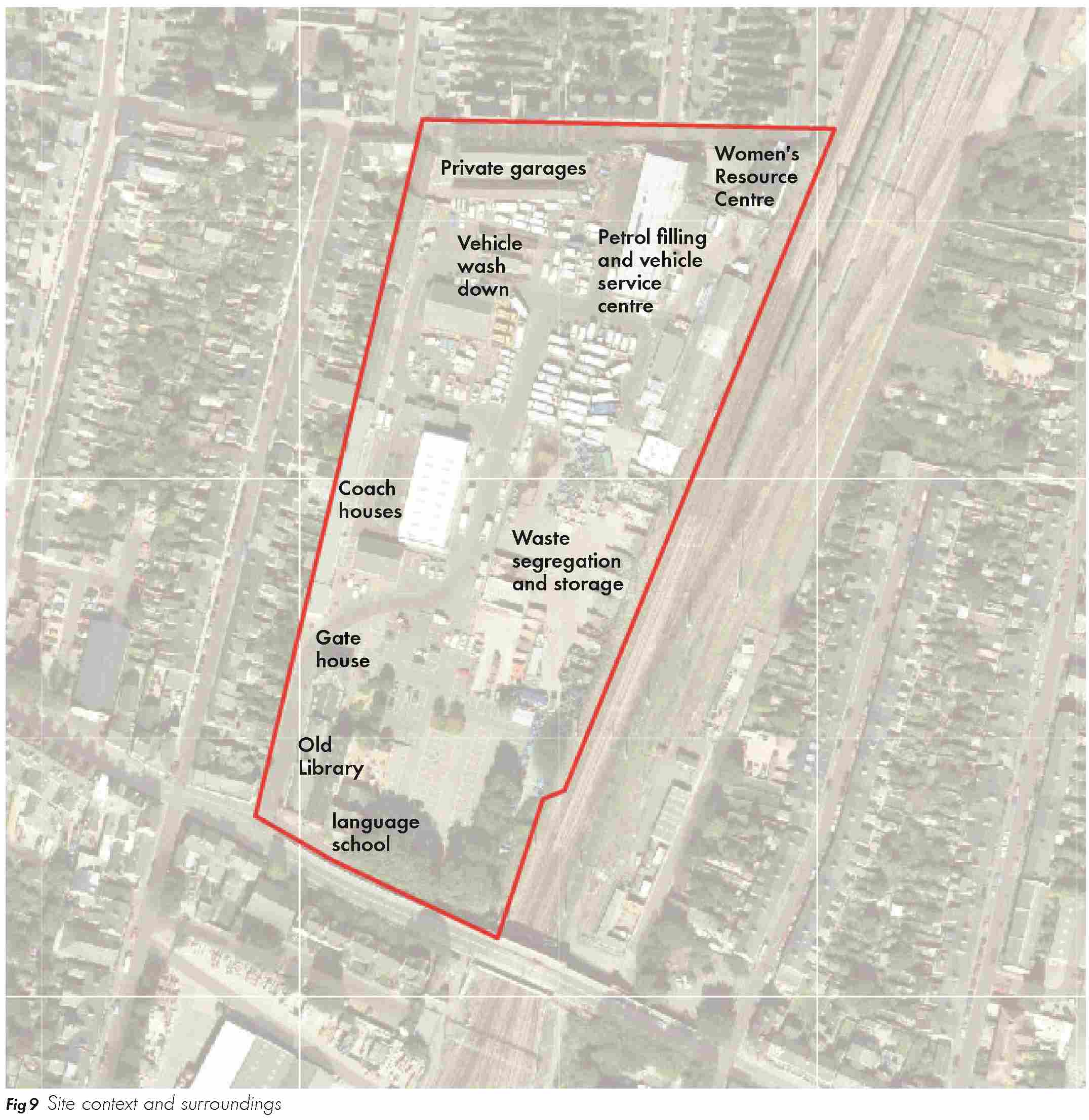
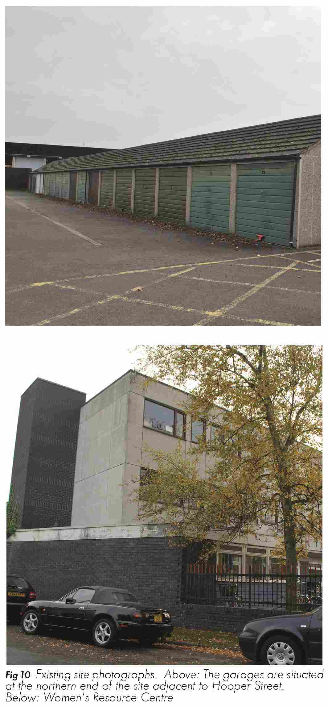
2.2.3 A garage/servicing centre for council vehicles and a filling station are located at the northern end of the site. A number of commercial units are also located here which are let out to private companies. In the centre are a number of warehouses and a vehicle wash down area. The central eastern area of the site has until recently been used as a waste transfer station and is currently used for waste segregation and storage. Private garages are located to the north-eastern corner.
(2) 2.2.4 Coach houses along the western boundary are used as an office space for the City Council. These have the potential to be retained for adaptive re-use to residential accommodation. The southern area is predominantly used for parking, along with a canteen and additional council offices located within the south western corner in the Gatehouse building. The Free Library, to the south-west of the site, is a Grade II Listed Building and will need to be retained. The building used as a language school is situated to the south of the site and, as already noted, is in separate ownership.
(1) 2.2.5 The site is adjacent to a predominantly residential area of Petersfield comprised of two-storey terraced housing, although a large warehouse and yard is located to the south of a row of shops / flats on the south side of Mill Road. There are also a number of independent shops, cafes, bars and public houses that are situated on Mill Road.
2.2.6 Some of these key features are illustrated in figures 9 and 10.
Movement context
Streets
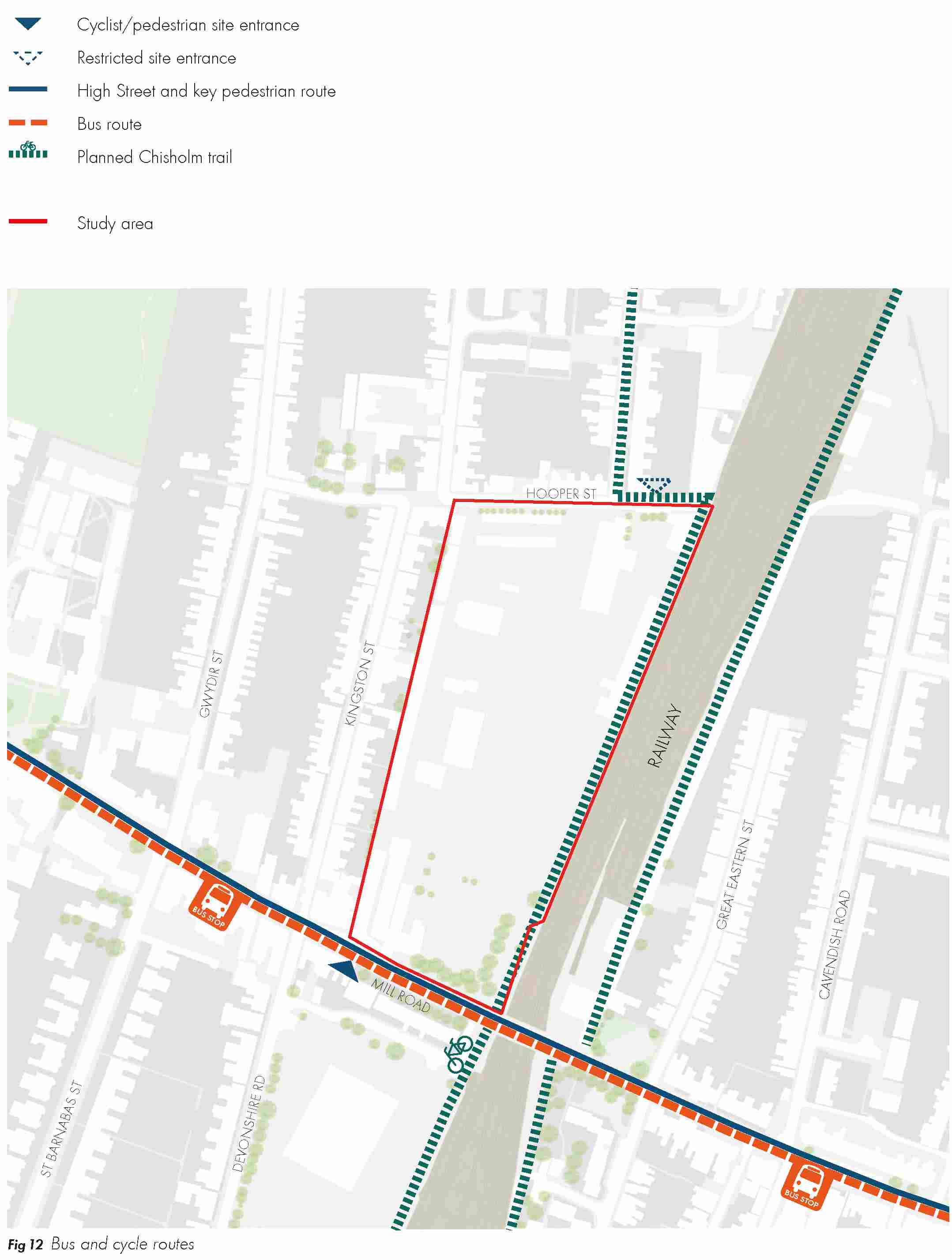
2.2.7 Key movement information is identified on figure 11.
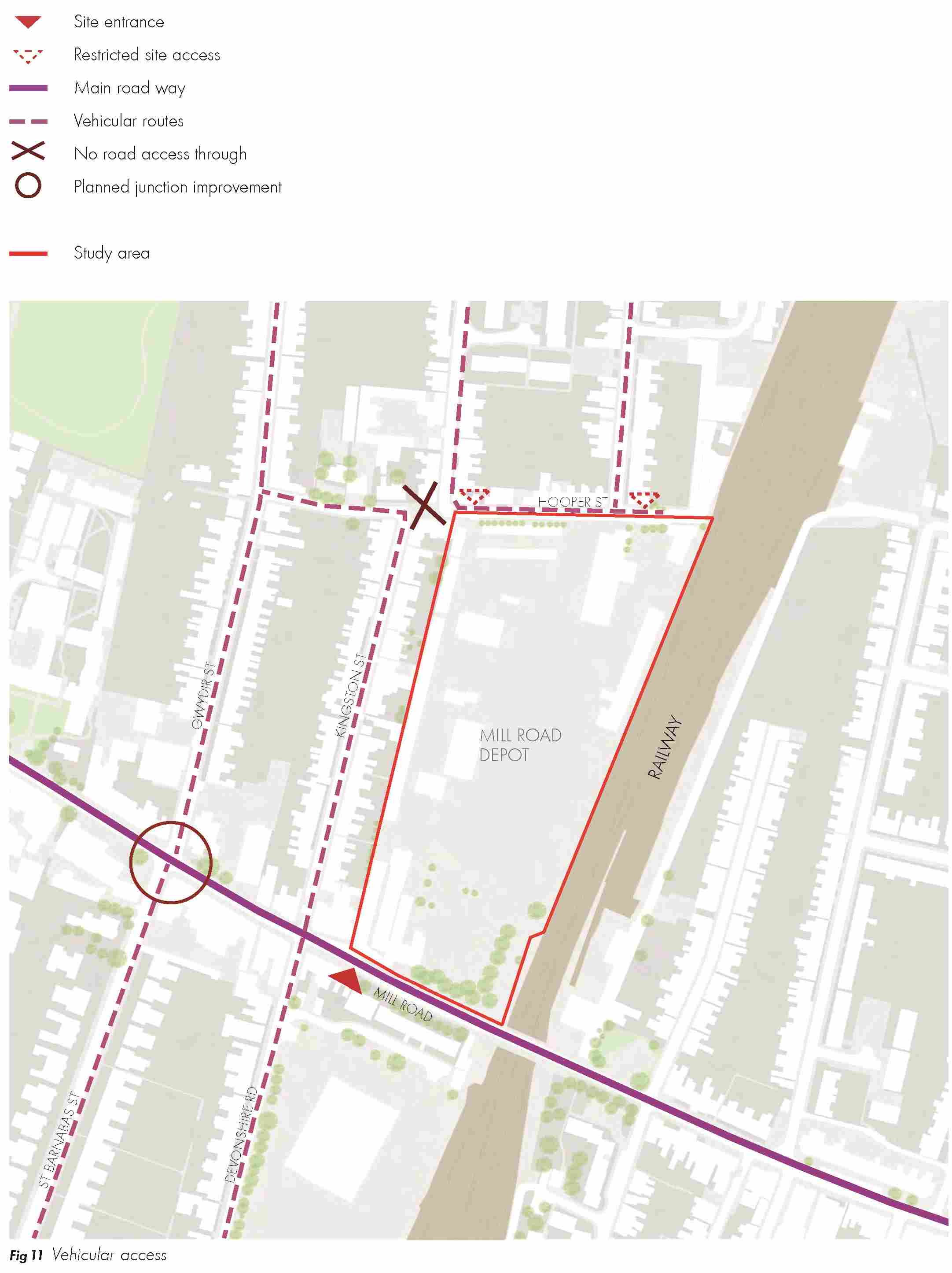
(3) 2.2.8 The residential streets to the west of the depot site are narrow and can be busy routes. These are important vehicular and pedestrian routes linking Mill Road to Newmarket Road and the north part of Petersfield ward. Kingston Street has parking on one side of the road which makes it difficult for cars to pass in both directions. Pavement widths are also restricted. There is a road block which prevents vehicular access onto Kingston Street from Hooper Street, restricting vehicular movement from re-joining Mill Road.
(2) Parking
2.2.9 The site is within a Controlled Parking Zone (CPZ) which means parking is restricted at certain times of day.
Rail and buses
2.2.10 There is excellent accessibility to Cambridge Railway Station, a short 5 minute walk in a southerly direction from the site. Bus links are also good with the Citi 2 bus route connecting Mill Road with Cambridge City Centre and Addenbrookes. The Beehive Centre, a 13 minute walk away, is serviced by the 114, 17 and 196 bus routes, linking the centre to locations including Waterbeach and Newmarket.
Click here for Fig 12
Cycle and pedestrian network
2.2.11 Mill Road is the main pedestrian route into Cambridge city centre. Footpaths are narrow, particularly on Mill Road Bridge, restricting pedestrian flow. On-road only cycling exists on Mill Road. Improvements to highway infrastructure may be necessary for the safety of cyclists and for improved accessibility to the site. There is a signed primary cycle network that crosses Mill Road from St. Barnabas Road to Gwydir Street, along Hooper Street and onto Ainsworth Street.
(3) 2.2.12 It is proposed that the Chisholm Trail will be a new north-south cycle route that will run along the railway line on the easterly side of the site. This will provide a high quality link to the station and to the planned Cambridge North station at its northerly end. It is currently proposed that the route will follow Ainsworth Street, and at Hooper Street, go diagonally across a section of the Women’s Resource Centre space. At its southerly end, it will follow the boundary of the railway and pass under a side arch to give a safe link to Mill Road via the existing connection adjacent to the Free Library building. This path will need to be incorporated into any potential plans for the site.
Open space
2.2.13 There is limited amount of protected open space in the area surrounding the Mill Road Depot site and the amount of informal open space in the ward is low given the very dense development form and the local population density. Figure 13 shows the amount of open space in the local area. Mill Road Cemetery (4ha) is the nearest protected natural green space, a 6 minute walk away. It is well used by the local community for recreation and is an important open space for wildlife. The other open spaces in the area are:
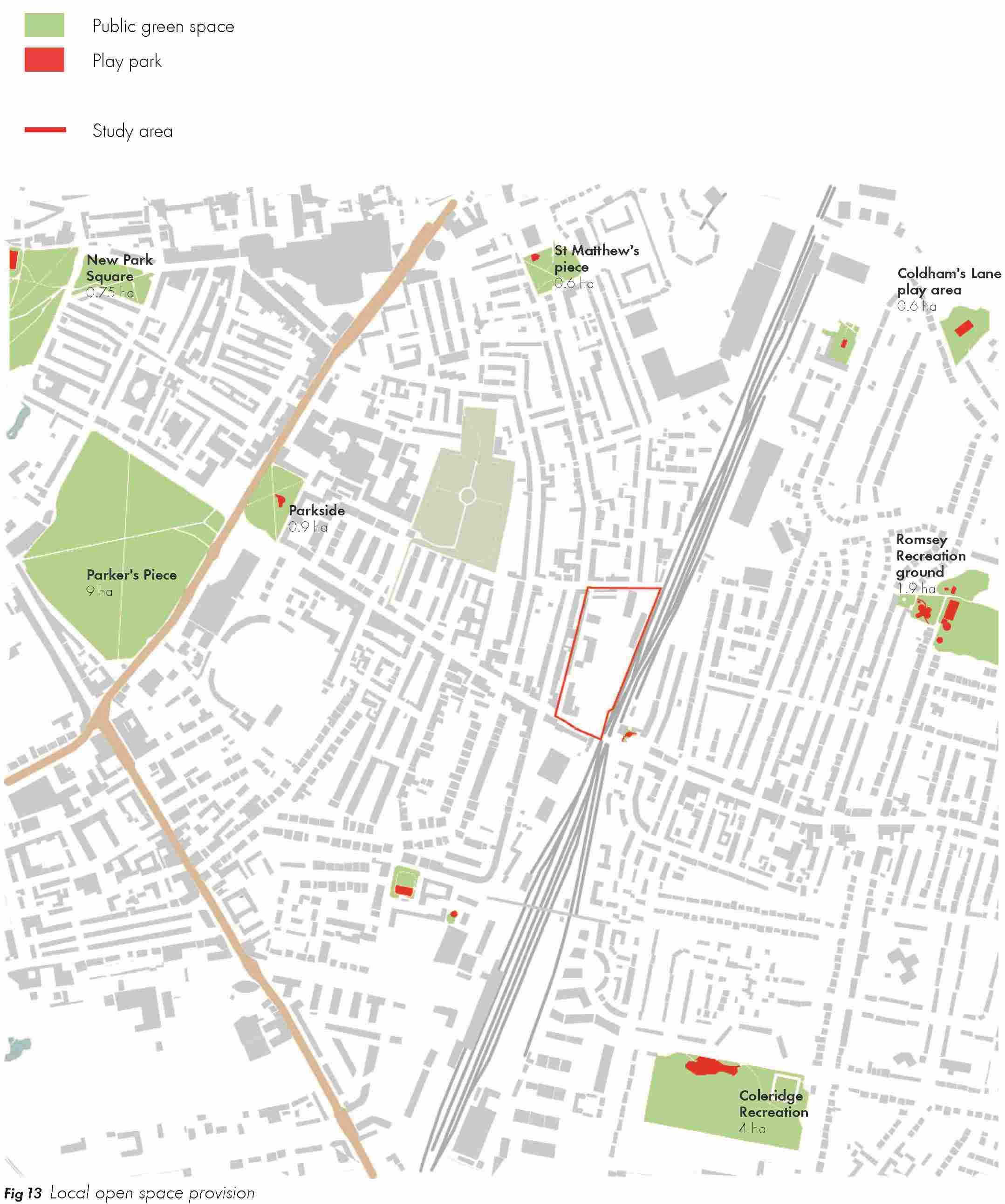
- St. Matthew’s Piece – 0.6ha (11 min walk), playground facilities for young and old children.
- Romsey Recreation – 1.9ha (15 min walk), public park with a children’s playground, green open space and mature trees.
- Coldhams Lane play area – 0.6ha (17 min walk)
- New Square Park – 0.75ha (16 min walk), green open space with planting.
- Parker’s Piece – 9ha (9 min walk), green common near the town centre for recreational activities such as football and cricket.
- Parkside – 0.9ha (9 min walk)
- Coleridge Recreation - 4ha (10 min walk), football field, tennis court, paddling pool and a newly refurbished children’s playground.
(1) 2.2.14 The development of the site is an opportunity to provide new open spaces for the local community.
Existing land uses
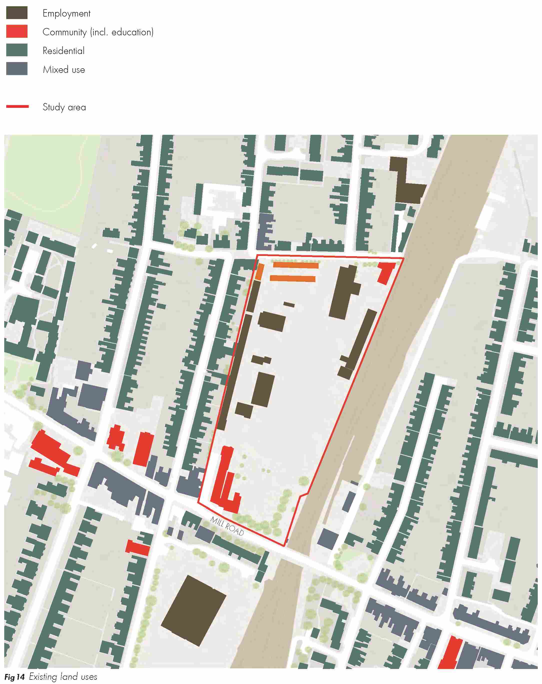
2.2.15 The majority of the site is currently used by the City Council as a Depot for many of its services, although some operations have recently re-located to a shared waste facility at Waterbeach with South Cambridgeshire District Council. There are two community buildings to the north-east and south-west of the site. These are currently occupied by the Women’s Resource Centre and Indian Community and Culture Association. The Regent Language School is located to the south of the site. The leased garages are to the north-west of the site. Figure 14 shows the existing land uses on site.
Site access
2.2.16 Main access to the site is gained via a roadway leading off Mill Road, as shown in figure 15. Mill Road is a major vehicular route into and out of the city centre. The consultation from the Local Plan process raised concerns about the safety of the junction between Devonshire Road and Mill Road.
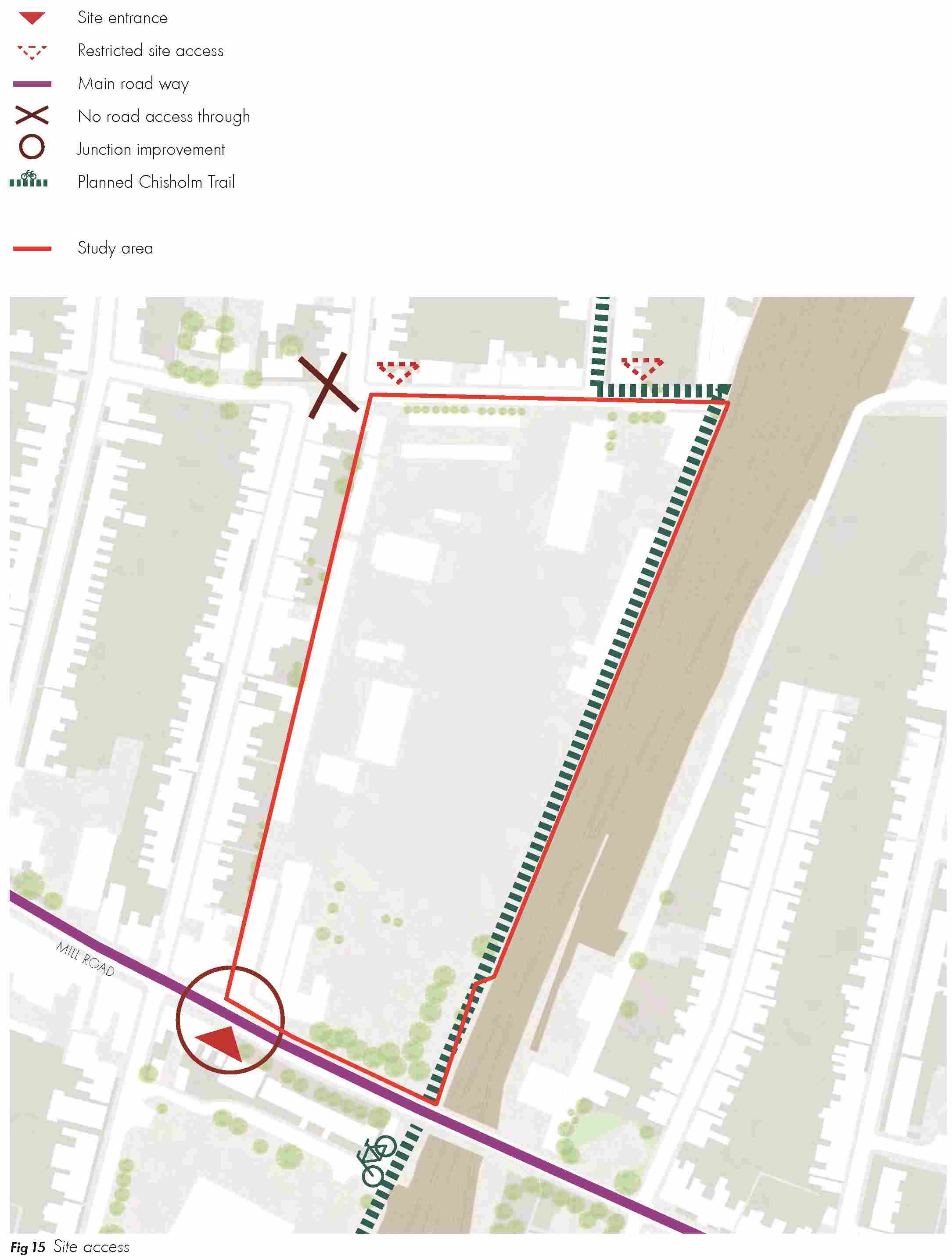
2.2.17 Mill Road is a very busy road and opportunities exist to improve access to the site. The junction currently suffers from poor visibility which is likely to be a constraint to be overcome as part of the scheme. Improvements to this junction will be necessary as part of any future re-development.
(2) 2.2.18 Vehicular access, both ingress and egress to the depot is restricted to the Mill Road entrance currently. The garages to the north-west off the site are accessed via Hooper Street.
2.2.19 The proposed Chisholm Trail will run through the site to the west of the railway line.
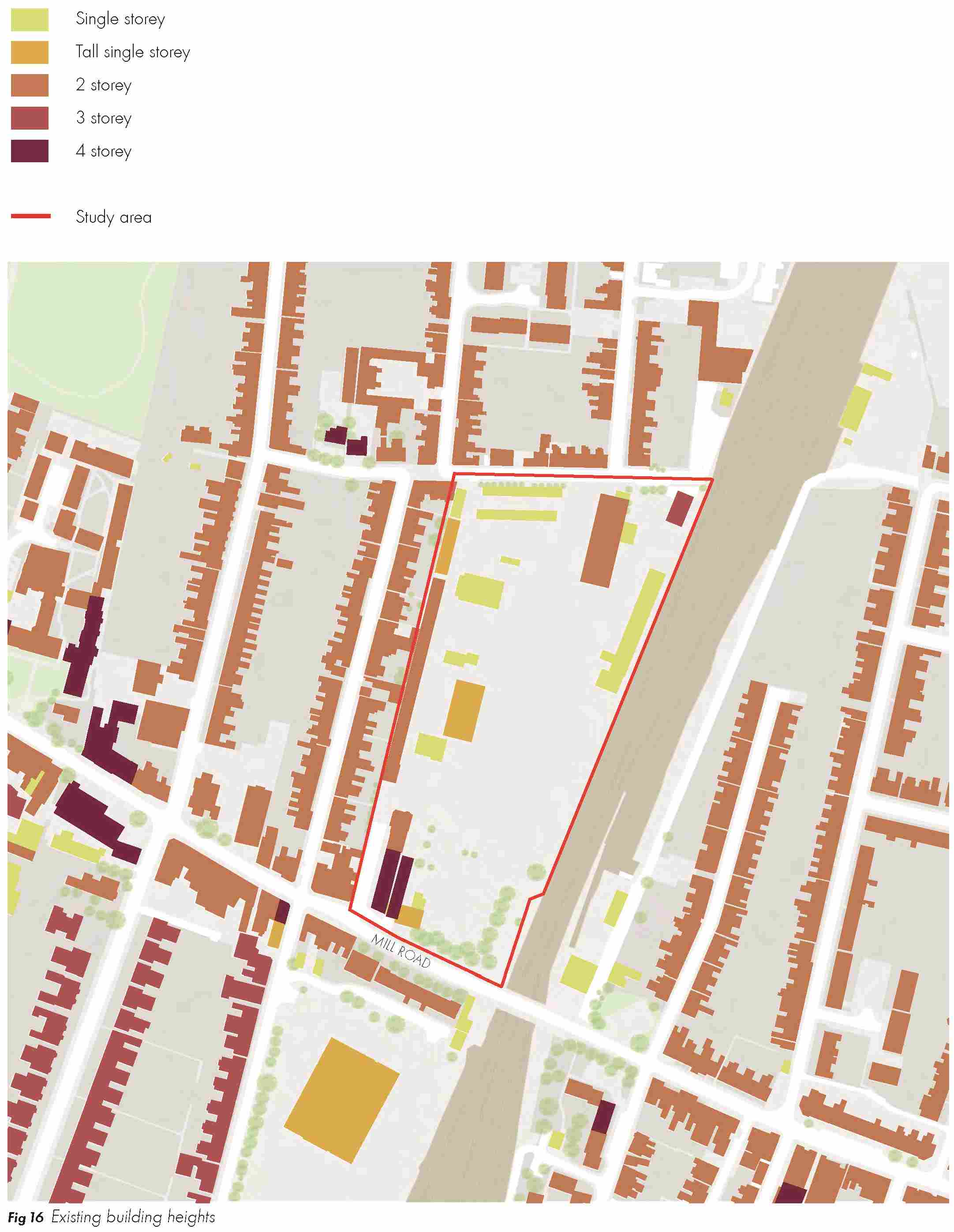
(1) Existing building heights
2.2.20 Building heights vary across the site, but predominantly comprise single-storey warehouses. The Free Library is also one- storey, although it is significantly taller and more striking than the one-storey warehouses. The servicing centre, Gatehouse building and the offices to the west are two-storey buildings. The Regent Language School, close to Mill Road to the south of the site, is a three-storey building.
(1) 2.2.21 The area surrounding the site is mainly comprised of residential two-storey housing, although there are a number of three-storey houses on Devonshire Road and St. Barnabas Road, to the other side of Mill Road. A few four- storey buildings form an exception to the average building heights in the area, and these tend to mark a specific use (e.g. churches and the brewery). Existing building heights are shown in figure 16.
Heritage assets
(2) Conservation Area
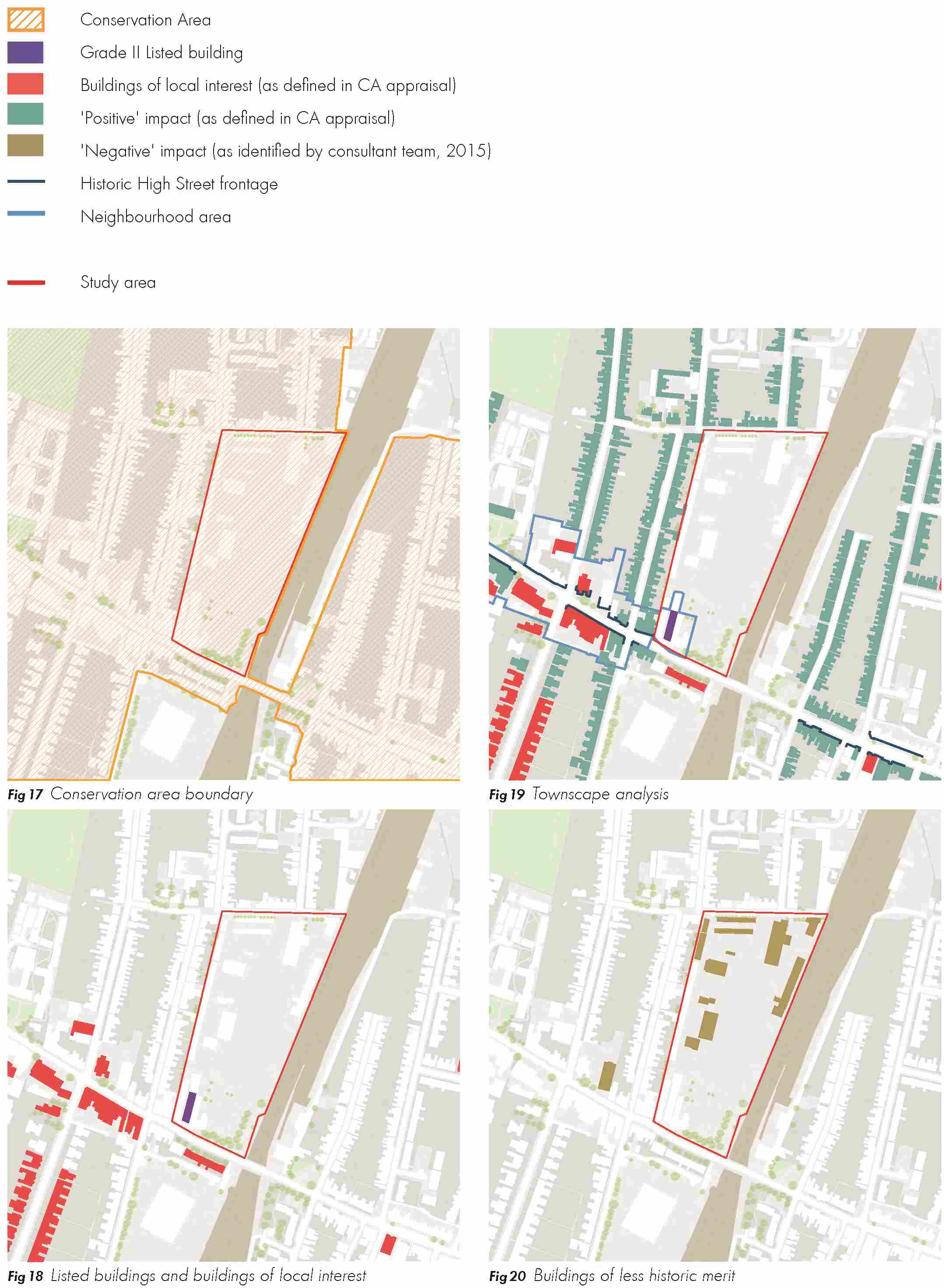
2.2.22 Mill Road Depot is located within the Mill Road Conservation Area, as defined in the Mill Road Conservation Area Appraisal (2011) prepared by Cambridge City Council and shown in figure 17. The area forms part of the ‘Cambridge Conservation Area No. 1 – Central’ which was originally designated in 1969, with the addition of Mill Road and St. Matthew’s area in 1993.
Click here for Fig 17
2.2.23 The main characteristic of the area are two- storey terraced houses, which directly address the pavement, and form long lines of continuous frontages. The streets are set out in a grid pattern at right angles to Mill Road. Another feature of the area are the preserved and well- detailed Victorian buildings surrounding Mill Road, with only a few examples of modern infill.
2.2.24 The area is home to a diverse multi-cultural community. It includes a number of mid to late 19th century buildings forming a mix of commercial, residential, religious and community uses. Mill Road itself has a number of two and three storey historic buildings with continuous frontages, contributing to the distinct character of the area. Some of these shopfronts have undergone replacement in recent years.
2.2.25 Under the Planning (Listed Buildings and Conservation Areas) Act 1990, the area is considered desirable to preserve or enhance for its ‘special architectural or historic interest’. Early consideration would need to be given to the impact of proposals on the setting and character of the Mill Road area for the redevelopment of the Mill Road Depot.
(2) 2.2.26 The main issues for the Mill Road Conservation Area, as identified in the Conversation Area Appraisal and of relevance to the depot site are:
- Preserving and enhancing the unique character of the Mill Road shopping area – improvements need to be made to some of the buildings and poor quality shopfronts.
- Public realm proposals – improvements need to be made to the poor quality public realm on Mill Road, including lighting, protection of historic street name plates, retention of historic street signs and pavement improvements.
(2) Listed Buildings
2.2.27 A Grade II Listed red brick and terracotta neo- Baroque building, constructed in 1897, is located in the south-western area of the site (see figure 18). Prior to its use as an Indian Cultural Centre, it was a library and was first listed in 1972. The building is of special architectural and historic interest and should be retained as part of any future re-development of the site. Consent must be sought to carry out alterations that would affect its character and setting.
Click here for Fig 18
2.2.28 There are three other listed buildings in the Conservation Area – St. Matthew’s Church, the Cemetery Lodge and Hughes Hall which are illustrated in the Conservation Area Appraisal (2011).
Buildings of Local Interest
2.2.29 There are a number of buildings in the area surrounding the depot site that are of local interest (see figure 18). These typically are terraced or semi-detached houses which vary in size and detail, but there are also a number of buildings in non-residential use, including a school, community buildings, several former warehouses, other industrial buildings, and a group of purpose-built shops in Mill Road. Buildings of Local Interest do not have the same statutory protection as graded buildings but are nevertheless considered heritage assets.
Click here for Fig 18
Positive and negative buildings
2.2.30 The Mill Road Conservation Area Appraisal (2011) gives details of a number of positive buildings of townscape merit, and shown in figure 19. These are buildings that have been relatively unaltered where their style, detailing and building materials provides the streetscape with interest and variety. Crucially, they make a positive contribution to the special interest of the Conservation Area. Most of the positive buildings in the area are mid to late 19th century terraced houses, and are mainly one bay wide.
Click here for Fig 19
(3) 2.2.31 There are a number of buildings on site that the Council has identified as negative buildings that have relatively less historic or design merit than other buildings in the area. These are shown in figure 20. These are not identified in the Area’s Conservation Appraisal document but, similar to the buildings identified in the Appraisal, make a negative contribution to the Mill Road Conservation Area. It is therefore deemed appropriate to remove these and replace them with buildings that will enhance the character and setting of the Mill Road conservation area.
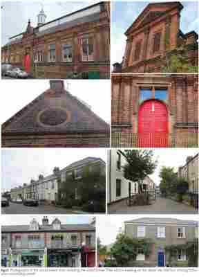
2.2.32 A selection of existing photographs of the Conservation Area are provided in figure 21.
(1) Trees and landscape
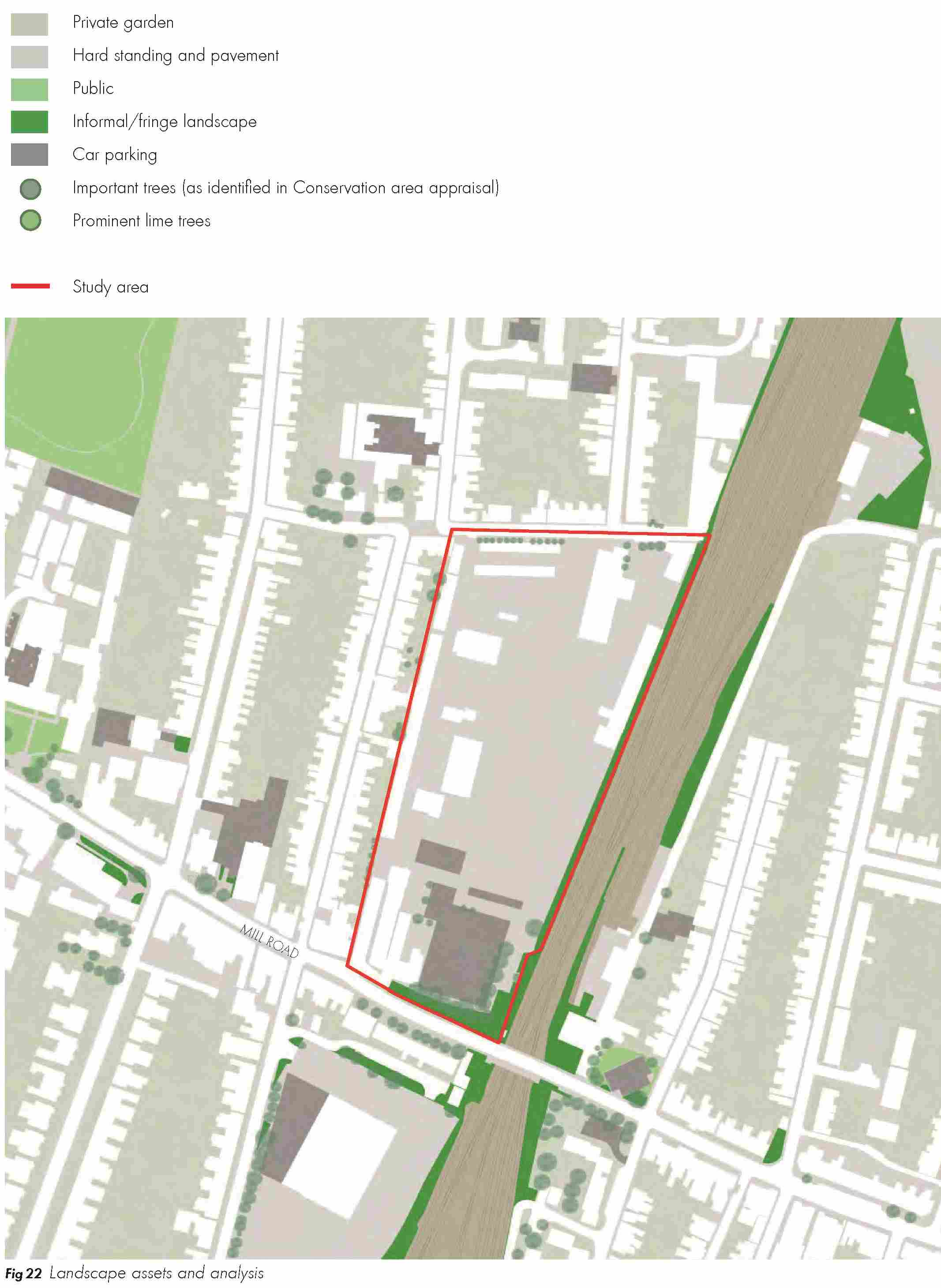
2.2.33 Mature trees make a significant contribution to the appearance and character of the Conservation Area. There is a row of mature trees to the north of the site to the south side of Hooper Street that are important to the streetscape and must be protected and enhanced under the Area’s Conservation Appraisal document. The trees at the southern end of the site adjacent to the bridge and language school are also important.
(1) 2.2.34 Due to the use of the site for industrial purposes, there is a deficiency in landscape features across the site. A cluster of mature trees are located to the south-east of the site which constitute a small amount of informal landscaping and are worthy of retention. Figure 22 illustrates existing landscape assets and analysis.
Environmental considerations
Noise
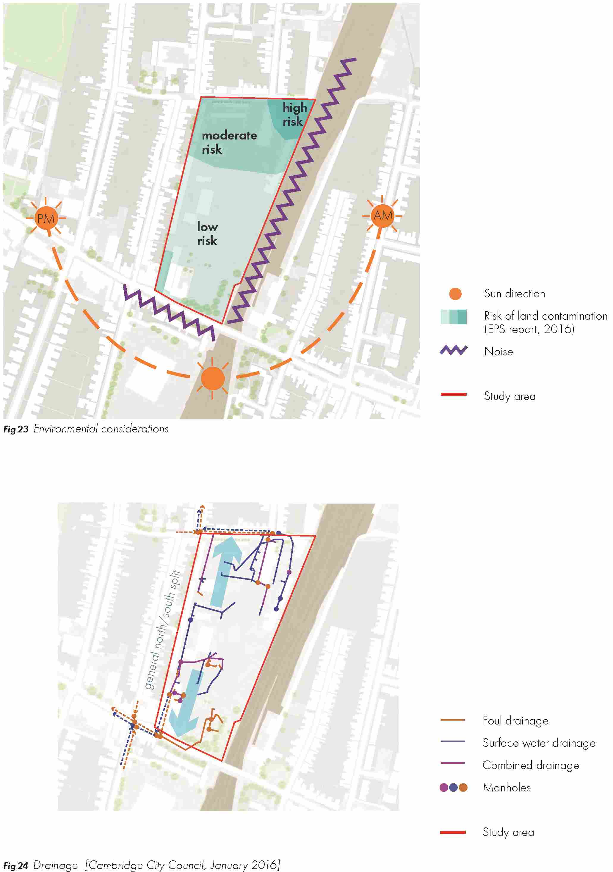
2.2.35 Key environmental considerations are identified on figure 23.
Click here for Fig 23
(1) 2.2.36 A noise assessment will be required to identify the potential impact of noise levels from the railway on the amenity of new residents of the Mill Road depot site. Attenuation measures may be necessary and innovative design solutions sought. A number of measures can be introduced to control the source of, or limit exposure to, noise and vibration as necessary.
(2) Land contamination
2.2.37 Given its present and historical industrial uses, there are pockets of contamination on- site. Cambridge City Council commissioned a survey in 2015 to identify the extent and impact of this on future development. The findings showed a general north-south split in terms of contamination across the site.
2.2.38 Elevated concentrations of various contaminants were identified associated with made ground across the site, which would not be suitable for use within proposed domestic garden or landscaped areas. More localised contamination was identified within the northern part of the site, especially surrounding the underground storage tanks (USTs). Impacts to soil and groundwater from fuels were identified within this area which will require further assessment.
Drainage and flooding
2.2.39 The site generally falls towards Hooper Street with levels around 15.0m A.O.D. adjacent to Hooper Street and levels of around 16.4m A.O.D in the south east corner and 15.8m A.O.D. outside of the gatehouse.
2.2.40 Current surface water drainage discharge is located in Hooper Street and in Mill Road. The surface water sewer in Hooper Street is 1.3m deep and the surface water sewer in Mill Road is 1.1m deep. Both of these are shallow and will mean that any drainage will have to be as high as possible to allow discharge under gravity.
2.2.41 The site lies within Flood Zone 1, defined by the National Planning Policy Framework (NPPF), and therefore has the lowest potential risk of fluvial or tidal flooding. There are minor surface water issues that can be mitigated against through good design. Opportunities exist to introduce sustainable urban drainage systems such as ditches, swales and ponds as part of future proposals.
2.2.42 Current foul drainage and surface water drainage is shown indicatively in figure 24.
2.3 SUMMARY OF OPPORTUNITIES AND CONSTRAINTS
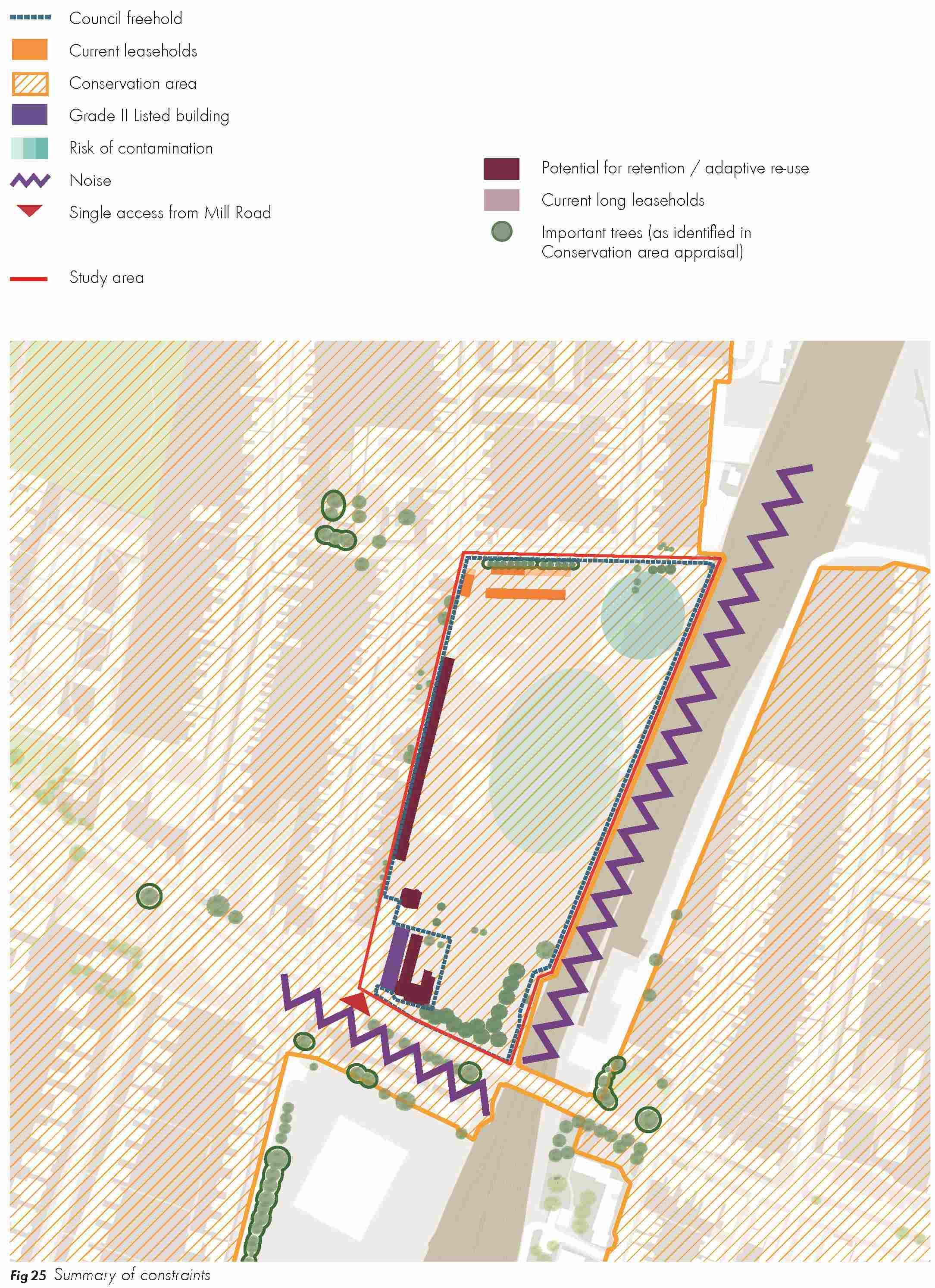
2.3.1 This chapter has highlighted a number of key constraints and opportunities that should be taken into consideration for future development of the Mill Road Depot site. These have been summarised below and are shown in figure 25.
(2) Constraints
2.3.2 The site has the following key constraints:
- The Language School site and buildings are not in City Council ownership;
- Vehicular access only from Mill Road and vehicular movement currently prevented re- joining Mill Road from Hooper Street;
- Poor cycling provision along Mill Road;
- The site is near a dangerous junction;
- Grade II listed library should be retained;
- The site lies within a Conservation Area;
- Potential impact of sound pollution from the railway on development; and
- Ground contamination is likely to require remediation and mitigation.
Opportunities
(2) 2.3.3 The opportunities of the site are:
- Integrate existing landscape and trees.
- Adapt and integrate Grade II Listed Building and coach house building on west side of site.
- Integrate existing garages in short term in such a way as to enable future housing fronting Hooper Street in the long-term.
- Re-integrate existing / invite new community uses to populate existing / new buildings.
- Create new edge to railway line.