Draft North East Cambridge Area Action Plan
5.5 North East Cambridge Centres
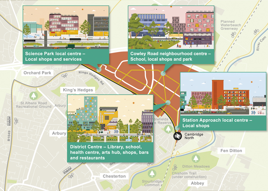
Figure 24: Location of new centres in North East Cambridge
There are four new centres for community services, retail, leisure and cultural activity within the North East Cambridge Area Action Plan area: District Centre, Science Park local centre, Station Approach local centre and Cowley Road neighbourhood centre. This section sets out the mix of uses that is envisaged in each centre, and principles for their design. It is also illustrated how this could be achieved in practice to make lively, welcoming and characterful places to visit, work and live.
- Broadly the comments received supported the Issues and Options Indicative Concept Plan. In particular, it was noted that there is support for encouraging people to travel by walking and cycling and that roads should be designed on the edges of the site to encourage quicker, easier and more sustainable ways of travelling.
- However it was also suggested that the district centre should be located around Cambridge North Station to create a 'destination' location containing retail and other town centre uses. However others suggested that the district centre be located within Cambridge Science Park at the planned Trinity College Hub.
- Generally most comments agreed that North East Cambridge should provide a range of supporting facilities, including shops, community facilities and socialising spaces, to create a place where people can enjoy living and working. These non-residential uses should be well integrated to help create vitality and vibrancy to this new city district.
- There was also support for some shopping provision in the vicinity of Cambridge Regional College as well as independent retail provision.
- You also told us that new services and facilities should be located close to existing residential areas in order for both new and existing residents to benefit.
How your comments and options have been taken into account
- The proposed policies provide further development requirements and design guidance for proposals that sit within the North East Cambridge centres. These policies, in combination with the other policies of the plan, identify how the centres should be designed around people rather than vehicle movements. The District Centre for example is 'access only', meaning that vehicle movements to Cambridge North Station and the Aggregates Railheads, are kept away from this important local hub of services and community facilities whilst ensuring pedestrians and cyclists are prioritised.
- The proposed approach to the location of the District Centre is for it to be located on Cowley Road between Cambridge North Station and Milton Road. This would place the centre at the intersection of important pedestrian and cycling routes, including new routes identified on the Area Action Plan Spatial Framework from the existing residential areas in East Chesterton. It is recognised that Cambridge North Station will be an important gateway location into the site and an important local transport hub. Therefore a local centre, referred to as Station Approach, is proposed for this location. The suggestion to locate the District Centre within Cambridge Science Park could undermine the potential for people to use this centre for day to day needs due to the physical separation of this area from the residential led development on the east side of Milton Road.
- The proposed policies within the plan identify that the centres should contain a mix of community, cultural and retail facilities and services to create areas of interest and vibrancy within the Area Action Plan area. Their locations, including the Cambridge Science Park local centre, mark the intersection of key routes for pedestrians and cyclists entering North East Cambridge from the residential communities to both the north and south in order for them to serve the daily needs of those living and working beyond the Area Action Plan boundary.
(7) Policy 10a: North East Cambridge Centres
The centres within North East Cambridge must be designed to create multi-functional, vibrant hubs for activity that build community and encourage a diversity of people to interact and dwell. Proposals must be designed to create a safe and active public realm which meets the needs of all parts of the community.
Development proposals within the identified district centres will be permitted where they are in accordance with the other policies of the Area Action Plan and address the following criteria:
- A mix of residential and employment (B1) uses should be provided above ground floor level, in accordance with Policy 12a: Business and Policy 13a: Housing;
- The provision of a range of retail units, varying in size between 50m2 and 110m2 which will serve the day to day needs of people living and working in this area, in accordance with Policy 15: Shops and local services;
- Community and cultural facilities, such as community centres, health facilities, libraries and multi-use cultural venues, should be provided within the identified centres as part of mixed-use buildings to make efficient use of land;
- Development should create a well-designed, high quality and inclusive public realm, providing spaces for movement, interaction, circulation, seating and biodiversity to enable public life to thrive. Streets and spaces should be designed to be multi-user, multi-generational, flexible, adaptable and climate change resilient;
- The storage of waste and recyclable materials, bicycles and utilities infrastructure should be integrated into the design of the building to avoid having a negative effect on the public realm;
- Proportionate on-site measures to support the creation, protection, enhancement and management of local biodiversity and Green Infrastructure;
- Due to the built-up nature of the centres, surface water flooding should be mitigated in the design of the development and public realm;
- Servicing should be accommodated 'on street'.
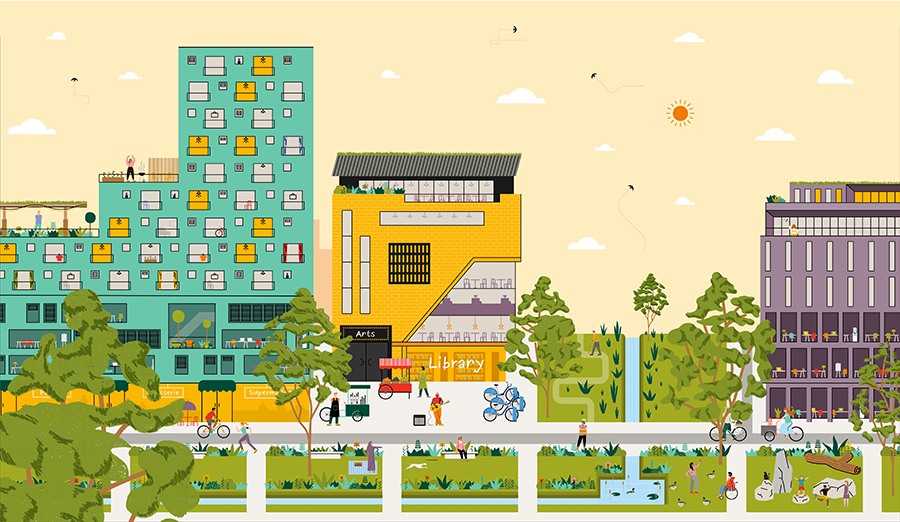
Figure 25: Illustration of the design vision for the District Centre
(6) Policy 10b: District Centre
|
Current/previous land uses
|
Veolia Waste Transfer Station Golf Driving Range Former Park and Ride facility Office buildings |
|
Acceptable land uses
|
Residential (see Policy 13a) Employment (B1a) (see policy 12a) Town Centre uses (see Policy 15) Community and cultural including primary school (see Policy 14) Health facilities (see Policy 14) |
|
Indicative development capacity
|
Residential uses: c.250 new homes Employment uses: c. 20,000m2 Retail uses: 5000m2 Community and cultural uses: 5,700m2 community and cultural uses, plus new primary school |
|
Ownership |
North – Cambridge City Council South – The Crown Estate |
|
Phasing |
2025-30 2030-35 2035-40 |
Development Requirements
Key enabling moves required to facilitate development include:
- The relocation of the Veolia Waste Transfer Station off-site, in accordance with the Cambridgeshire and Peterborough Minerals and Waste Core Strategy and Proposals Map (and future successor document: Minerals and Waste Local Plan);
- The off-site relocation of the Golf Driving range.
Appropriate uses
- A mix of retail, community, cultural and education provision to support day to day needs within North East Cambridge;
- Employment (B1) and residential development above ground floor level;
- Open space and amenity provision as part of First Public Drain and District Square.
Design requirements
- Development should improve the arrival experience to the District Centre from the surrounding areas;
- Development within Cambridge Business Park that falls within this centre will be required to form the southern half of the District Centre. Proposals will be required to reflect the grain, scale and form of development on the northern side to create a coherent and legible District Centre;
- The First Public Drain is a key asset that should be protected and enhanced as a biodiversity corridor and safe amenity space which is integrated into the District Centre;
-
A new District Square should be created at the intersection of the District Centre, diagonal link and Linear Park. The design of the District Square should:
- Support a range of creative local businesses in creating a sense of place in the District Square through the provision of flexible space for market stalls to operate;
- Provide opportunity for local businesses to trade, on a weekly basis. In addition, farmers markets and seasonal markets may operate throughout the year alongside other events and everyday life activities in this space;
- Promote a large public, high quality and lively gathering place which is mixed-use, for local residents and employees to use; while creating a distinctive sense of place, optimising the use of public space;
- Provide appropriate space for market and other event storage within adjacent public buildings or facilities;
- Provide the necessary infrastructure to support a range of activities including electricity for pitches and designated loading and unloading spaces.
- Be designed to complement rather than conflict with the neighbouring uses in terms of quality of life / amenity issues such as noise, odour and servicing.
- The public realm within the District Centre should provide spaces which are available for everyone to enjoy all year round, during the day and evening and that are safe. These spaces should invite people to spend time there to help foster social interaction.
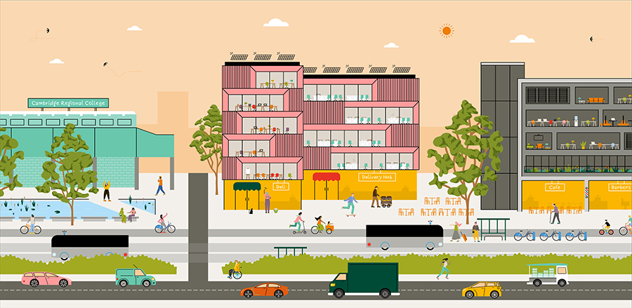
Figure 26: Illustration of the design vision for the Science Park Local Centre
(3) Policy 10c: Science Park Local Centre
|
Current/previous land uses |
Vacant land – extant planning permission for B1 building |
|
Acceptable land uses
|
Residential (see Policy 13a) Employment (B1) (see Policy 12a) Town Centre uses including retail (see Policy 15) Community and cultural (see Policy 14) Logistics Hub (see Policy 12b) Car Barn (see Policy 22) |
|
Indicative development capacity
|
Employment uses: c. 4,800m2 Logistics hub: 1,150m2 Retail uses: 1,000m2 Community and cultural uses: 100m2 |
|
Ownership |
Trinity College |
|
Phasing |
2030-35 |
Development Requirements
Appropriate uses
- Retail and community floorspace appropriate to the role and size of the Local Centre with employment (B1) floorspace above ground floor level;
- A small logistics hub to be located within Local Centre to consolidate last mile deliveries. Last mile deliveries should be by sustainable modes, including zero-carbon means.
Design requirements
- Development should improve the arrival experience to the Local Centre and Cambridge Science Park from Cambridge Regional College and the surrounding areas;
- A high quality amenity and biodiversity public open space should be provided to the east of the local centre to enhance the entrance to Cambridge Science Park in this location;
- An enhanced public space should be formed to encourage street activity and opportunities for people to dwell within an inviting public realm;
- Development should address King's Hedges Road/Cambridgeshire Guided Busway through active frontages where possible and by bringing the building line forward to create a strong urban character;
- There is an opportunity to enhance the junction with the Cambridgeshire Guided Busway and Kings Hedges Road through significant public realm improvements including tree planting and pedestrian and cycling crossings. This would need to be carried out in partnership between the Greater Cambridge Partnership, Cambridgeshire County Council, Cambridge Science Park and Cambridge Regional College. Proposals should be designed to encourage the through movement of people from the Guided Busway bus stop to Cambridge Regional College.
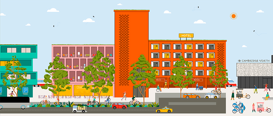
Figure 27: Illustration of the design vision for Station Approach local centre
(4) Policy 10d: Station Approach
|
Current/previous land uses |
Railway car park Former railway sidings Vacant land |
|
Acceptable land uses
|
Residential (see Policy 13a) Employment (B1a) (see Policy 12a) Town Centre uses including retail (see Policy 15) Community and Cultural Uses (see Policy 14) |
|
Indicative development capacity
|
Residential uses: c. 500 homes Employment uses: c. 15,000m2 Retail uses: 1,000m2 Community and cultural uses: 100m2 |
|
Ownership |
Chesterton Partnership (Formed of Network Rail / DB Schenker / Brookgate) |
|
Phasing |
2030-35 |
Development Requirements
Appropriate uses
- Retail and community floorspace appropriate to the role and size of the Local Centre with employment (B1) floorspace and residential above ground floor level.
Design Requirements
- The existing station car park should be re-provided in a more efficient multi-storey car barn as part of a mixed-use higher density development proposal;
- Development should improve the arrival experience from Cambridge North Station;
- Development should mitigate adverse impacts on residential amenity and public open spaces from the adjacent railway line, station, Cambridgeshire Guided Busway and any future CAM portal;
- This area contains land with potential high biodiversity value, therefore a detailed ecological assessment should be undertaken to identify the biodiversity value present and recommend a strategy for minimising loss and maximising biodiversity gain (see Policy 5: Biodiversity and Net Gain) Key routes and connections;
- Safeguard land to accommodate the CAM (Cambridge Autonomous Metro) (including interim construction site) adjacent to Cambridge North Station to facilitate a transport hub (in accordance with Policy 19: Safeguarding for Cambridge Autonomous Metro and Public Transport);
- Development proposals should consider taking the First Public Drain overflow out of its culvert which extends into 'the Knuckle' and flows through to Chesterton Fen;
- Station Approach should provide attractive, safe and generous pedestrian and cycling provision linking the Waterbeach Greenway and the Chisholm Trail;
- A new public open space (Station Place) along Station Approach should be provided to create an informal space which offers opportunities for people to dwell and interact;
- Due to wider landscape and townscape sensitivities, major development in this location should be informed by a Landscape Visual Impact Assessment and a Townscape Assessment/Appraisal.
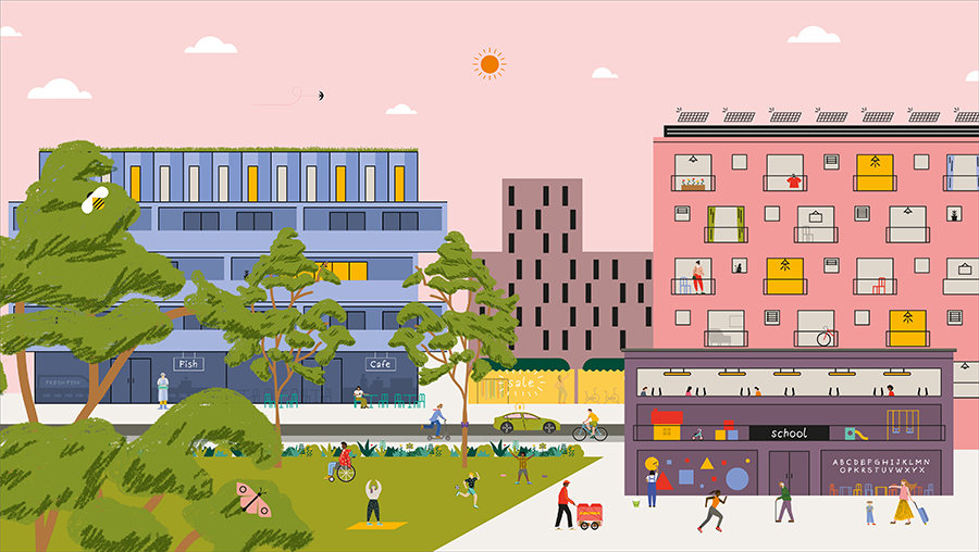
Figure 28: Illustration of the design vision for Cowley Road neighbourhood centre
(6) Policy 10e: Cowley Road Neighbourhood Centre
|
Current/previous land uses |
St Johns Innovation Park (Offices/R&D) Anglian Water Waste Water Treatment Plant |
|
Acceptable land uses
|
Residential (see Policy 13a) Employment (B1a) (see Policy 12a) Town Centre uses including retail (see Policy 15) School campus to include:
|
|
Indicative development capacity
|
Residential uses: c. 100 homes Employment uses: c. 3,000m2 Retail uses: 3,000m2 Community and cultural uses: primary school, secondary school (if required) |
|
Ownership |
West of Cowley Road: St Johns College East of Cowley Road: Anglian Water |
|
Phasing |
2030-35 2035-2040 |
Development Requirements
Appropriate uses:
- A primary and secondary school (if required) campus to form the anchor of the neighbourhood centre; mix of residential and employment (B1) should be provided above ground floor level, in accordance with Policy 13a and Policy 12a;
- The school campus should be integrated within the neighbourhood centre.
Design requirements
- Development should mitigate adverse impacts on residential amenity, education facilities and public open spaces from the A14 and Milton Road;
- The Cowley Road Hedgerow, a City Wildlife Site, should be protected and enhanced as part of development and public realm proposals;
- A new open space (Cowley Triangle) and square should be created at the intersection of the Cowley Road neighbourhood centre, diagonal link and new connection to Cambridge Science Park which can form the basis for informal open space and public events, providing opportunities for people to dwell and interact;
- Development should address the street along Cowley Road through active frontages where possible and by moving the building line closer to the street to introduce a new urban character;
- To allow for easy movement through the centre, circulation space should be provided outside of the school campus;
- Opportunities for schools to be delivered as part of mixed-use buildings/developments should be explored.
Relevant objectives: 1, 2, 3, 4, 5
There are a number of overarching principles which will apply to all development proposals within each North East Cambridge centre, as well as bespoke requirements and design guidance applicable to specific centres across the new city district. These policies set out how these new centres will create vibrant, multi-functional, community spaces for new and existing residents, workers, visitors and students.
The centres should be thought of as more than just transport or movement corridors. They should be considered and planned as the foundation for public life, public health, for social and cultural exchange and for the promotion of sustainable and liveable lifestyle. A multi-user and multi-generational approach to their design, programme and management will create the conditions for public life to thrive throughout the day and evening. This should include opportunities to dwell, meet family and friends, play and exercise.
District Centre
The North East Cambridge District Centre will be the focus of this new city district. It will provide a mix of land uses that will support the day to day needs of the people living, working and visiting North East Cambridge and the adjacent neighbourhoods. The District Centre will contain residential units in the form of apartments and employment floorspace. Ground floors will be activated through retail, community and cultural uses.
The District Centre will also prioritise pedestrians and cyclists, with limited and well managed servicing and delivery vehicle access. Located between the primary access route towards Cambridge North railway station and the Cambridgeshire Guided Busway, the district centre will be easily accessible by public transport.
The District Centre will be the key link between Cambridge North Station and Cambridge Science Park in terms of land use and activity. It will provide a significant amount of retail floorspace comprising a mixture of 'town centre uses' including comparison and convenience shopping as well as food and beverage. The retail offer in the District Centre will encourage independent retailers as much as possible, although high street chains could be accommodated within smaller units as typically found on local high streets.
The area will also be the community and cultural hub for the area, the location for much of the community spaces, venues and events space. Outdoor community events should be primarily located within the new District Square which lies at the intersection between key local and strategic pedestrian and cycle routes. This new District Square will also be anchored by a new primary school and community and cultural uses.
The First Public Drain is a key biodiversity asset of the site and will need to be well integrated with the new District Centre. Development either side of the watercourse should capitalize on this unique asset for both biodiversity enhancement as well as integration within the street as part of a new attractive public realm.
The District Centre will be the heart of this new community and the streets and public spaces should be designed around the needs of all, from the young to the old, residents, workers and visitors. Buildings should have a positive relationship with the street and open spaces to create a place where public life can thrive.
Beyond the District Centre, a new pedestrian and cycling bridge will connect over Milton Road to Cambridge Science Park. There will need to be a strong visual relationship between the district centre and the new bridge to create a seamless link that is well used by people and helps bring the two sides of Milton Road together as part of this new city district.
Science Park Local Centre
The Cambridge Science Park Local Centre is positioned at the southwestern corner of Cambridge Science Park and is adjacent to Cambridge Regional College and King's Hedges Road. The site has good existing accessibility to the Cambridgeshire Guided Busway and by foot and cycle to the adjacent residential areas of King's Hedges, Arbury and Orchard Park.
Development in this location should address King's Hedges Road to create a welcoming entrance into Cambridge Science Park. The provision of community and cultural space and retail units delivered as part of an employment led mixed-use development will also serve local residents, employees and students in this area.
To further enhance this entrance into Cambridge Science Park, there is an opportunity to create a new public open space to the east of the local centre which can form part of both the local amenity offer in this part of Cambridge Science Park but also connect into the wider green network. This space should be accessible and welcoming to all and encourage social interaction. This open space will also assist in this local centre achieving biodiversity and water management requirements.
The creation of this new centre provides the opportunity to enhance the existing junction of Cambridge Regional College and King's Hedges Road, which will further improve the area's accessibility by foot and cycle from the surrounding residential areas.
A small logistics hub has been identified for this site to facilitate last mile deliveries for Cambridge Science Park and potentially some of the wider North East Cambridge area. This facility would allow for deliveries to be consolidated close to the main road network before they are delivered to individual buildings by sustainable transport modes, preferably by zero-carbon means.
Station Approach
Station Approach will be a key transition place between Cambridge North Station and the District Centre. It will therefore be crucial that development is planned in a comprehensive manner to ensure that key issues such as land uses, active frontages and street activity are addressed whilst delivering well designed streets, spaces and wayfinding to create a place that is easy to find your way around.
This area is identified for mixed-use development, primarily comprising business space and apartments brought forward alongside a small amount of ground floor retail provision and community and cultural uses. Development in this area will need to respond to the constraints of the nearby railway and station in order to protect residential amenity.
Redevelopment of the long-stay Cambridge North station surface car park will need to ensure that this car parking is re-provided as part of a mixed-use development in order to maximise the efficient use of land. The exact amount of car parking to be re-provided for the station will need to consider its good current accessibility by walking, cycling and public transport, the improvements to accessibility, as well as the wider constraints on highway capacity. The current primary access route along the east-west section of Cowley Road to Cambridge North Station will be realigned further north so as to avoid HGV, bus and other vehicle movements through the District Centre (see Chapter 5 and Area Action Plan Spatial Framework).
The area around the bend in Cowley Road, known as 'The Knuckle', is a key point along the district spine and development in this location should be of exceptional design quality which aids legibility along this key route. Nevertheless, development in this area will be highly visible from the sensitive wider Fen landscape and from the River Cam, as set out in Policy 9.
Cowley Road Neighbourhood Centre
Cowley Road Neighbourhood Centre is positioned on the intersection of a number of key pedestrian and cycling routes within the North East Cambridge area. This includes the new underpass under Milton Road between Cambridge Science Park and St John's Innovation Park as well as the main pedestrian and cycle route between North Cambridge railway station and, via the Jane Coston Bridge, to Milton. This Neighbourhood Centre is anchored by a new primary and secondary school campus, (subject to the secondary school being required in accordance with Policy 14: Social, community and cultural Infrastructure), and supported by a number of small retail units that will serve the day to day needs of people living and working locally. It would also contain some commercial (B1) floorspace that would front Cowley Road.
The Cowley Road Neighbourhood Centre also extends into St John's Innovation Park, where a small amount of ancillary retail space would extend the local centre over Cowley Road and form part of the new underpass link to Cambridge Science Park.
The Cowley Triangle green space provides an opportunity to encourage social interaction between those living, working and studying in area. The space should be well designed and welcoming to all and include opportunities to dwell, socialise and relax.
- North East Cambridge Landscape Character & Visual Impact Appraisal (2020)
- Innovation District Paper (2019)
- Typologies and Development Capacity Assessment (2020)
- North East Cambridge Stakeholder Design Workshops 1-6 – event records (2019-2020)
- National Design Guide, Planning practice guidance for beautiful, enduring and successful places, MHCLG (2019)
- Super density – the sequel (2015) HTA, Levitt Bernstein, PTEa and PRP
- North East Cambridge Ecology Study (Biodiversity Assessment) (2020)
- Community Safety Topic Paper (2020)
- Anti-Poverty and Inequalities Topic Paper (2020)
- Employment floorspace consented and delivered per centre
- Residential units consented and delivered per centre
- Retail floorspace consented and delivered per centre
- Community and cultural floorspace consented and delivered per centre
- Policy 15: Cambridge Northern Fringe East and new railway Station Area of major Change
- Policy 37: Cambridge Airport Public Safety Zone and Air Safeguarding Zones
- Policy 40: Development and expansion of business space
- Policy 55: Responding to context
- Policy 56: Creating successful places
- Policy 57: Designing new buildings
- Policy 59: Designing landscape and the public realm
- Policy 60: Tall buildings and the skyline of Cambridge
- Appendix F: Tall Buildings and the Skyline
- Policy 65: Visual pollution
- Policy 67: Protection of open space
- Policy 68: Open space and recreation provision through new development
- Appendix I: Open Spaces and Recreation Standards
- Policy 69: Protection of sites of biodiversity and geodiversity importance
- Policy 70: Protection of priority species and habitats
- Policy 71: Trees
- Policy 80: Supporting sustainable access to development
South Cambridgeshire Local Plan 2018
- SS/4: Cambridge Northern Fringe East and Cambridge North railway station
- HQ/1: Design Principles
- NH/2: Protecting and Enhancing Landscape Character
- NH/4: Biodiversity
- NH/5: Sites of Biodiversity or Geological Importance
- NH/6: Green Infrastructure
- H/8: Housing Density
- SC/1: Allocation for Open Space
- TI/1: Chesterton Rail Station and Interchange
- TI/4: Rail Freight and Interchanges
- TI/6: Cambridge Airport Public Safety Zone
- TI/8: Infrastructure and New Developments
- TI/9: Education Facilities