Draft North East Cambridge Area Action Plan
5.4 Density, heights, scale and massing
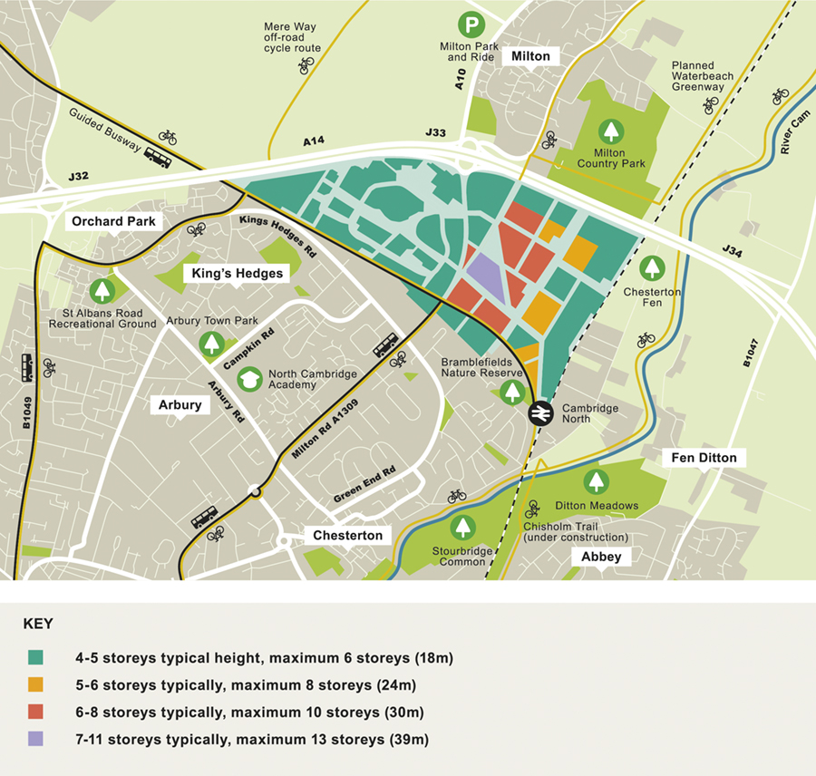
Figure 21: Building heights considered suitable for North East Cambridge
North East Cambridge should be a place which enables people to live, work and relax within walking distance of everything they need. Building to a higher density means land can be used more efficiently and it makes community services, shops and other facilities more viable. The Councils have undertaken evidence which shows that it is possible to build taller in some parts of the area without a negative impact on the wider landscape. This policy sets out expected building heights and densities across the area and how the scale and massing (shape) of buildings should consider its impact on the skyline.
- There was a mix of views provided regarding scale and massing at North East Cambridge. There was support for using higher densities where there is good accessibility around the transport hubs including Cambridge North Station and around key amenity spaces. Eddington at North West Cambridge was cited as an example of a good medium height and varied density development and accordingly high-quality design was considered key to ensuring the area could manage higher densities appropriately.
- Concern was expressed that taller buildings would have a negative impact on the rural settings of the River Cam, Fen Ditton and wider Cambridge Green Belt which are near the North East Cambridge area. Further concerns were expressed that taller buildings may impact on the historic core of Cambridge. A suggested 'cap' of 6-8 floors was suggested by some with a lower maximum of 2-4 storeys suggested by others.
- However, there were concerns raised about very high-density development, with a feeling that it should be low density with 'ample green space' provided. The impact of taller buildings often associated with higher density development, and the importance of assessing visual harm, was highlighted.
- Concern was raised about microclimatic issues created by tall buildings.
- The need to properly assess building heights and densities within development proposals was highlighted by several respondents. The use of Visual Impact Assessment methodologies to assess whether tall buildings will be harmful on the setting of Cambridge was highlighted. It was noted that a sound evidence base and understanding of what a higher density development at North East Cambridge will do in terms of impact were highlighted as important for informing the preferred policy approach. The need to consider aspects such as the airport safety zone were raised too.
- There was support for the idea of making development within North East Cambridge more visible from Milton Road. There was concern raised about the area feeling too urban and visually cluttered and that a rural character should be 'maintained' with the idea of adding commercial frontages onto a five-line highway considered 'appalling'. It was also raised that it would be important to consider the relationship between new development and Milton Road and how this could inform enhanced walking and cycling provision.
How your comments and options have been taken into account
- The proposed policy considers the importance of both density and good design together to ensure the delivery of a well-designed higher density new city district. The density of development is informed by its accessibility to sustainable transport modes such as key pedestrian and cycle links, the Cambridgeshire Guided Busway and the transport interchange associated with Cambridge North Station.
- To understand the potential impact of development, the Councils have undertaken a Landscape Character and Visual Impact Appraisal to inform the preferred policy but are also commissioning a Heritage Impact and Townscape Assessment to inform a wider Townscape Strategy for North East Cambridge. This will ensure that taller buildings as part of development at North East Cambridge will not impact on the Historic Core of Cambridge, the setting of the City and surrounding heritage assets, as well as nearby established residential neighbourhoods.
- With respect to the landscape assessment the potential impact of taller buildings has been considered and locations have been identified where taller buildings can be located to minimise harm on the wider Fen landscape. These locations have then informed the positioning of the district and local centres and the subsequent proximity to sustainable transport connections. Building heights can also help with wayfinding and district identity and so localised increases in height are being considered to promote this. Whilst overall heights are taller than the heights of 2-6 storeys suggested in comments, the strategy is to bring forward a range of building heights to create a varied and well-articulated skyline, the ambition of which is reflected in the policy.
- In response to concerns that the new District could be a windy and heavily shaded place, it is important that, when planning for tall buildings, a high-quality street level environment is created. It must be human in scale and resolve microclimatic issues to produce well designed, attractive and comfortable streets and spaces throughout the year. Cross-sections have been devised to show the scale of the street width to building heights as part of each of the centres throughout the North East Cambridge area. These demonstrate how large-scale trees, footways and other open spaces can be easily accommodated whilst delivering the scale of development required to make development at North East Cambridge viable and acceptable.
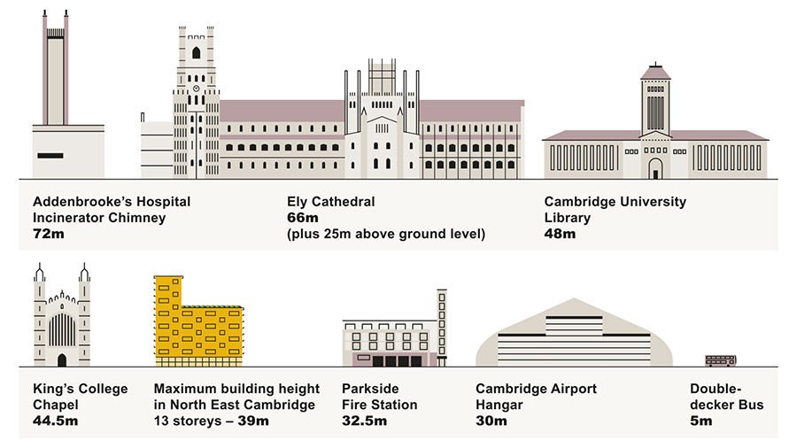
Figure 22: Comparison of proposed building heights within North East Cambridge, and existing taller buildings in the area.
(23) Policy 9: Density, heights, scale and massing
Development densities and building heights should not exceed those identified on Figure 21 and Figure 23. Densities and intensification of appropriate uses will increase around highly accessible parts of the Area Action Plan area taking into account wider development sensitives, and activity clusters such as the District Centre and Cambridge North Station.
The overall approach to building densities, heights, scale and massing for all development proposals at North East Cambridge will be expected to create a well-articulated and varied skyline throughout the area. Localised increases in height should be located to help define key centres of activity within the area and help with wayfinding.
Through appropriate landscape and visual impact assessment, heritage impact assessment and massing studies, proposals will be required to carefully assess and consider their impact on the historic and wider skyline and their relationships with the surrounding context, the setting of Cambridge and Fen Edge approaches, including their relationship to the Fen Ditton Conservation Area and other heritage assets. Proposals will be required to demonstrate how they will:
- Be of exemplary design which is proportional and elegant;
- Create a well-articulated and varied skyline;
- Make a positive contribution to the local and wider skyline;
- Optimise pedestrian comfort at street level as part of creating a human scale environment;
- Help contribute to making a place that is easy to find your way around;
- Ensure adequate separation between buildings to limit the cumulative impact of scale and massing;
- Ensure that microclimatic impacts are assessed and resolved as part of proposals including understanding cumulative impacts from nearby development;
- Ensure that servicing, management and maintenance are an integral part of the planning and design of new buildings;
- Where required, undertake an Airport Safeguarding Assessment to understand any implications of buildings over 15m (AOD) on the operational requirements of Cambridge Airport.
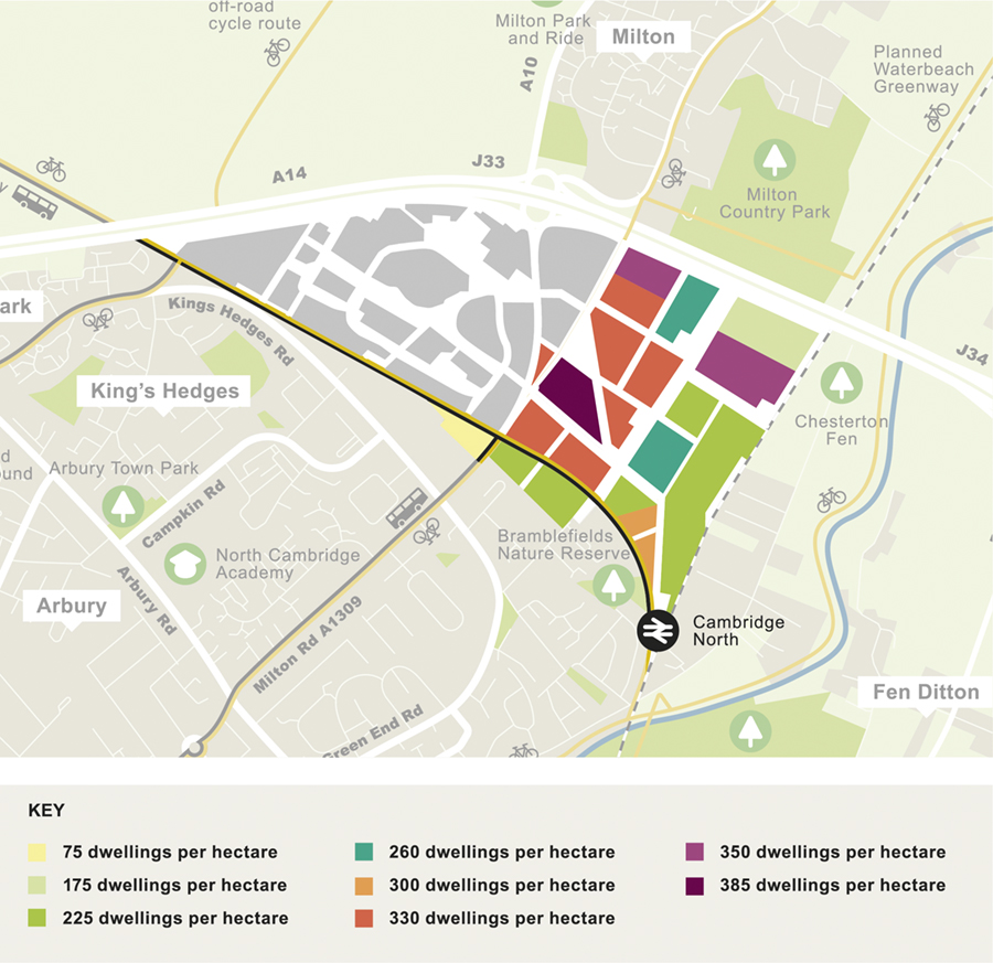
Figure 23: Residential densities considered suitable for North East Cambridge
Relevant objectives: 1, 2, 3, 4, 5
North East Cambridge will be of a size to create a self-sustaining place that provides homes, employment, leisure and other activities. To achieve such a place, the density of the area should support the range of activities and uses needed, along with making best and most efficient use of the land available, and the site's accessibility to Cambridge North Station and the associated transport interchange. Building heights and the density of development are closely related and in considering building heights, densities, scale and massing, a balance needs to be struck between safeguarding the setting of Cambridge, its key approach and historic core and providing sufficient development potential to create a strong and vibrant district.
Density
The density of development will play a significant role in determining the kind of place created. It helps to define the character of development through the urban form, building types utilised and the quality of open spaces and streets that form the structure of urban places.
National policy requires planning authorities to make the best and efficient use of such available land and to link the density of development to accessibility by public transport infrastructure. The MHCLG National Design Guide (2019) paragraph 63 advocates compact forms of development as a method of bringing people together and supports 'local public transport, facilities and local services' to 'reduce dependency upon the private car'. Such 'transport orientated development' is the model employed in major urban centres and recognises the benefits of low private car dependency when compact, walkable places are created that maximise opportunities to provide shops and services close to, and embedded into, mixed use districts that also provide homes and jobs. Density is also intrinsically linked to the ability to sustain services and facilities and provide what people need in their day to day lives.
The Area Action Plan will facilitate the delivery of a compact, higher density new city district that maximises walking and cycling connectivity and will deliver a radically different form of development which uses the benefits of density and mixed use high quality context driven design that responds to the established character of Cambridge and the surrounding established places.
In line with National Planning Policy Framework Paragraph 137, that advocates the uplifting of density 'in town centres and other locations well served by public transport', development at North East Cambridge will be expected to make efficient and effective use of brownfield land available to achieve a critical mass of population required to create a self-supporting new city district that internalises trips and takes advantage of existing and planned public transport that provides good accessibility on foot and by bicycle.
A range of development typologies and densities have been considered within the Typology and Development Capacity Study that have informed the understanding of site capacity and how different land uses can be compatible and land efficient. North East Cambridge will deliver a significant uplift in existing commercial floorspace within the Area Action Plan area along with greater housing densities established elsewhere in Greater Cambridge. Buildings will need to be innovative to provide a range of uses to deliver an appropriately dense predominantly mid-rise, attractive street based new city district.
Building heights
Building heights in Cambridge have long been a topic that has created heated discussion over the decades with people both for and against taller buildings. Cambridge has taken a cautious approach to managing tall buildings in the city with Local Plan Policy 60 Tall Buildings and the Skyline and supporting Appendix F advocating a case by case assessment based on a series of set criteria. Such an approach has recognised that even modest increases in height in certain areas of the city have potential to impact on surrounding established neighbourhoods and views from vantage points around and within the city. The prevailing scale of development in the city is currently between 2 and 5 storeys with other taller structures in prominent locations.
In 2009, Cambridge City Council organised a debate on the topic 'Is tall beautiful?'. This conversation revealed that there were concerns around planning for taller buildings and if tall buildings were going to be allowed in Cambridge, there was little support for taller buildings within the City's historic core. There was general agreement that any new taller buildings must be sympathetic to their context and position, that they should have a 'sense of place' and be of high quality both in respect of design and materials. It was considered that tall buildings must also be sustainable, environmentally friendly and connected to established infrastructure, particularly public transport. Finally, it was felt that a more proactive "strategy" was needed in order to avoid the potential for a piecemeal approach to the location of tall buildings across the City.
Approach to building heights in North East Cambridge
The North East Cambridge area lies approximately 2.5 miles (4kms) north east of the historic core of Cambridge and so the impact on the Historic Core needs to be considered in terms of the potential to impact on the setting of the City from approach routes, and from the various vantage points that allow the historic core in relation to the outlying areas to be understood.
The size of the North East Cambridge area means that a managed approach to scale, massing and the location of tall buildings is needed to help safeguard the setting of the City and to set out a clear strategy within the development area to tie in with a placemaking led approach that requires high quality streets and spaces with great architecture. Whilst Policy 60 and appendix F of the Cambridge Local Plan (2018) will be used for the detailed assessment of proposals for tall buildings coming forward at North East Cambridge, this policy, supporting diagrams and Spatial Framework will be used to manage and plan for where taller buildings can be suitably located.
Overall building heights have initially been tested through a Landscape Character and Visual Impact Appraisal. The Councils are undertaking further work in liaison with Historic England to consider the impact of taller buildings on heritage assets, the setting of the city and local townscape through a Heritage Impact and Townscape Assessment. These studies will inform a Townscape Strategy which will draw together the recommendations and conclusions from both reports to help define a tall building approach at North East Cambridge that maximises development capacity but does not harm the setting of Cambridge, its Historic core, the wider Fen landscape or other nearby heritage assets.
Assessments so far have concluded that there is capacity to accommodate some taller buildings in the District Centre without causing a detrimental impact on the wider Fen landscape around North East Cambridge. Development at North East Cambridge could be up to an equivalent of 13 residential storeys or 39m inclusive of roof top plant (residential floor to floor height of 3m) within the District Centre and this represents a significant increase from the predominant building heights in the City. However, buildings and groups of buildings will need to create a varied and well-articulated skyline, where taller buildings read as incidents and where each considers its impact on the immediate and wider context.
Elsewhere across North East Cambridge there may be local opportunities to increase heights of buildings above the prevailing scale of other new buildings where they have a role in wayfinding, defining key open spaces or maximising proximity and accessibility to sustainable transport infrastructure. Proposals for taller buildings will need to demonstrate that they do not harm the amenity of their surroundings, the setting of the City and the wider landscape character.
North East Cambridge falls within the Cambridge Airport Safeguarding Zone and therefore where taller buildings are proposed may have implications on the airport's operational requirements. Development proposals over 15m AOD will be required to prepare an Airport Safeguarding Assessment to demonstrate that it will not impact on Cambridge Airport in terms of aircraft and airport operational safety.
Figure 21 is based on an assumed floor to floor height for residential use of 3m and overall indicated heights are inclusive of plant and lift overruns. It is expected that ground floors will be 4m floor to floor to accommodate non-residential uses. While the plan shows typical height ranges, lower forms will also be acceptable and it is expected that a design led approach will be taken to achieve a human scale, plot-based approach to development.
- North East Cambridge Landscape Character & Visual Appraisal (2020)
- Innovation District Paper (2019)
- Typologies and Development Capacity Assessment (2020)
- North East Cambridge Stakeholder Design Workshops 1-6 – event records (2019-2020)
- 'Towards an Urban Renaissance' (1999) by The Urban Task Force
- National Planning Policy Framework (2019)
- National Design Guide, Planning practice guidance for beautiful, enduring and successful places, MHCLG (2019)
- Super density – the sequel (2015) HTA, Levitt Bernstein, PTEa and PRP
- Number of awards (shortlisted, finalist, winner) received
- Positive recommendations made to Planning Committee
- Floorspace approved
- Policy 15: Cambridge Northern Fringe East and new railway Station Area of major Change
- Policy 37: Cambridge Airport Public Safety Zone and Air Safeguarding Zones
- Policy 40: Development and expansion of business space
- Policy 50: Residential space standards
- Policy 51: Accessible homes
- Policy 55: Responding to context
- Policy 56: Creating successful places
- Policy 57: Designing new buildings
- Policy 59: Designing landscape and the public realm
- Policy 60: Tall buildings and the skyline of Cambridge
- Appendix F: Tall Buildings and the Skyline
- Policy 65: Visual pollution
- Policy 67: Protection of open space
- Policy 68: Open space and recreation provision through new development
- Appendix I: Open Spaces and Recreation Standards
- Policy 69: Protection of sites of biodiversity and geodiversity importance
- Policy 70: Protection of priority species and habitats
- Policy 71: Trees
- Policy 80: Supporting sustainable access to development
South Cambridgeshire Local Plan 2018
SS/4: Cambridge Northern Fringe East and Cambridge North railway station
HQ/1: Design Principles
NH/2: Protecting and Enhancing Landscape Character
NH/4: Biodiversity
NH/5: Sites of Biodiversity or Geological Importance
NH/6: Green Infrastructure
NH/8: Mitigating the Impact of Development in and adjoining the Green Belt
NH/14: Heritage Assets
H/8: Housing Density
H/12: Residential Space Standards
H/18: Working at Home
SC/1: Allocation for Open Space
TI/1: Chesterton Rail Station and Interchange
TI/4: Rail Freight and Interchanges
TI/6: Cambridge Airport Public Safety Zone
TI/8: Infrastructure and New Developments
TI/9: Education