Draft North East Cambridge Area Action Plan
(1) 8.9 Trajectories
This section of the Area Action Plan provides details about delivery of development across North East Cambridge including area specific data for each of the development areas over the plan period and beyond. It gives an indication of how much development will take place in each area and when.
The National Planning Policy Framework (NPPF) requires strategic policies to include a trajectory illustrating the expected rate of housing delivery over the Plan period. In preparing the trajectories for the Plan, the Councils have had regard to a number of factors:
- The anticipated date of adoption of the Area Action Plan;
- The relocation of the Waste Water Treatment Plant and decommission of existing site;
-
A higher than average but reasonable build rate for the development, informed by on-going engagement with the landowners/developers, based on:
- current expectations of the housing and employment market;
- efficient building processes such as modular housing;
- the housing types to be delivered; and
- housing tenures which support quick delivery (e.g. Build to Rent).
However, all these assumptions must be heavily caveated that, in the event of any changes, for example the economic impact of COVID-19 and/or further discussions with landowners and developers, the rate of delivery may not be achievable.
Engagement with landowners and developers in preparing the plan has suggested that they anticipate that 530 homes per year could be delivered at North East Cambridge over the plan period. The level of development assumed by the Councils on strategic sites is typically 250 dwellings per year. Given the nature of the proposed development at North East Cambridge, there is the potential for this to accelerated through some of the assumptions noted above. This will be kept under review and maybe refined as necessary drawing on evidence being prepared to support the emerging Greater Cambridge Local Plan and further engagement with landowners and developers.
The phasing of business floorspace is anticipated to be fairly continuous throughout the plan period. Engagement with landowners/developers and evidence base documents note that a significant amount of business floorspace can be delivered and absorbed by the market during the plan period. The re-provision of industrial floorspace is anticipated to come forward steadily across the plan period. This reflects that land within Chesterton sidings is within single ownership, whilst Cowley Road Industrial Estate is made up of fragmented land ownership where existing lease arrangements and some off-site relocations (i.e. Veolia Waste Transfer Station) are likely to mean that development will be delivered from the middle of the plan period in this area. The Councils will be preparing a Relocation Strategy to further inform these delivery assumptions for industrial floorspace. For both business and industrial floorspace delivery, this is also caveated that in the event of any changes, for example the economic impact of COVID-19 and/or further discussions with landowners and developers, the rate of delivery may not be achievable.
8.9.1 Residential
Figure 43 below provides a summary of the broad distribution of the housing provision set out in the plan. At this stage, the Councils are not advocating this programme but are inviting comment on the assumptions set out.
|
Residential - Net additional units |
2020/25 |
2025/30 |
2030/35 |
2035/40 |
Plan Period |
2040+ |
Total |
|
Anglian Water / Cambridge City Council Site |
- |
2,250 |
2,129 |
1,122 |
5,500 |
- |
5,500 |
|
Cambridge Business Park |
- | - |
500 |
- |
500 |
- |
500 |
|
Cambridge Science Park |
- | - | - | - | -
|
- |
0 |
|
Chesterton Sidings |
- |
365 |
365 |
- |
730 |
240 |
970 |
|
St John's Innovation Park |
- | - | - | - | -
|
- |
0 |
|
Trinity Hall Farm Industrial Estate |
- | - | - | - | -
|
- |
0 |
|
Nuffield Road |
- | - |
275 |
275 |
550 |
110 |
660 |
|
Cowley Road Industrial Estate |
- | - |
250 |
250 |
500 |
- |
500 |
|
Merlin Place |
- | - | - |
120 |
120 |
- |
120 |
|
Milton Road Car Garage |
- | - | - |
100 |
100 |
- |
100 |
|
Cambridge Regional College |
- | - | - | - | -
|
- |
0 |
| - |
- |
2,494 |
3,154 |
1,867 |
8,000 |
350 |
8,350 |
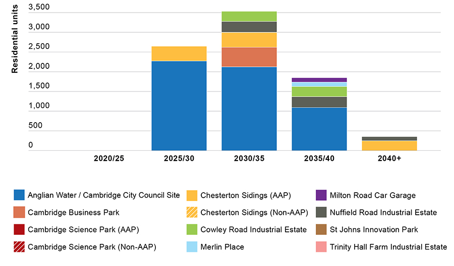
Figure 43: Indicative residential development trajectory
8.9.2 B1 development
Figure 44 below provides a summary of the broad distribution of the office development (B1) provision set out in the plan. At this stage, the Councils are not advocating this programme but are inviting comment on the assumptions set out.
|
B1 - Net additional (m2) |
2020/25 |
2025/30 |
2030/35 |
2035/40 |
Plan Period |
2040+ |
Total |
|
Anglian Water / Cambridge City Council Site |
3,536 |
4,715 |
7,073 |
8,176 |
23,500 |
- |
23,500 |
|
Cambridge Business Park |
22,400 |
22,800 |
22,800 |
- |
68,000 |
- |
68,000 |
|
Cambridge Science Park (AAP) |
7,993 |
17,552 |
16,654 |
27,801 |
70,000 |
13,057 |
83,057 |
|
Cambridge Science Park (Existing commitments) |
33,750 |
- | - | - |
33,750 |
- |
33,750 |
|
Chesterton Sidings (AAP) |
14,600 |
21,900 |
- | - |
36,500 |
- |
36,500 |
|
Chesterton Sidings (Existing commitments) |
9,700 |
- | - | - |
9,700 |
- |
9,700 |
|
St John's Innovation Park |
9,080 |
7,160 |
9,380 |
9,380 |
35,000 |
4,700 |
39,700 |
|
Trinity Hall Farm Industrial Estate |
1,500 |
- | - | - |
1,500 |
- |
1,500 |
|
Nuffield Road |
- | - | - | - | -
|
- | - |
|
Cowley Road Industrial Estate |
- | - | - | - | -
|
- | - |
|
Merlin Place |
- | - | - | - | -
|
- | - |
|
Milton Road Car Garage |
- | - | - | - | -
|
- | - |
|
Cambridge Regional College |
- | - | - | - | -
|
- | - |
| - |
102,559 |
74,127 |
55,907 |
45,357 |
277,950 |
17,757 |
295,707 |
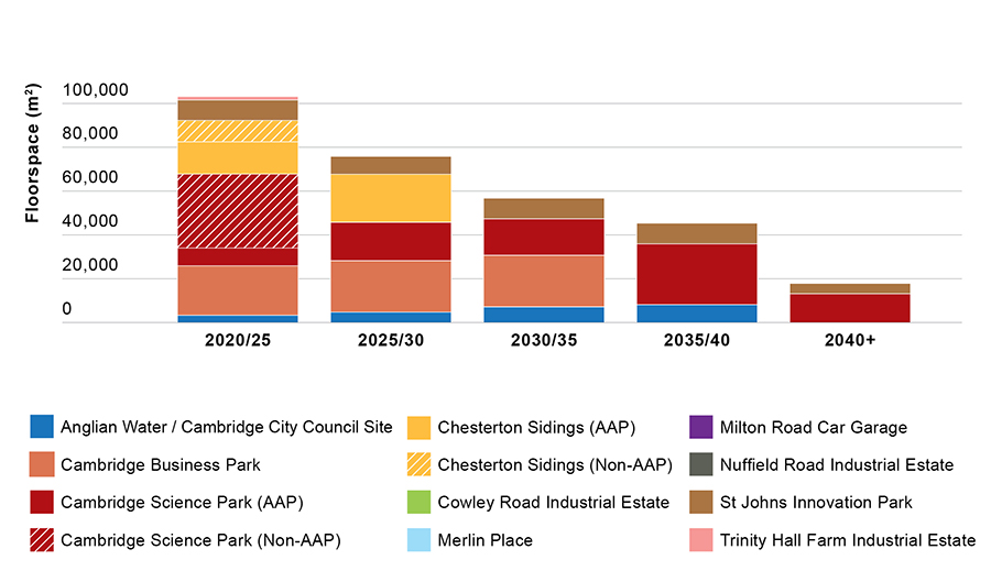
Figure 44: Indicative B1 development trajectory
8.9.3 B2/B8 development
Figure 45 below provides a summary of the broad distribution of the industrial development (B2 and B8) provision set out in the plan. At this stage, the Councils are not advocating this programme but are inviting comment on the assumptions set out.
|
B2/B8 - Net additional (m2) |
2020/25 |
2025/30 |
2030/35 |
2035/40 |
Plan Period |
2040+ |
Total |
|
Anglian Water / Cambridge City Council Site |
- | - | - | - | - | - | - |
|
Cambridge Business Park |
- | - | - | - | - | - | - |
|
Cambridge Science Park (AAP) |
- |
1,159 |
- | - |
1,159 |
- |
1,159 |
|
Cambridge Science Park (Existing commitments) |
5,060 |
- | - | - |
5,060 |
- |
5,060 |
|
Chesterton Sidings |
3,800 |
5,000 |
- | - |
8,800 |
- |
8,800 |
|
St John's Innovation Park |
- | - | - | - | -
|
- | - |
|
Trinity Hall Farm Industrial Estate |
- | - | - | - | -
|
- | - |
|
Nuffield Road |
- | - | - | - | -
|
- | - |
|
Cowley Road Industrial Estate |
- |
6,000 |
7,000 |
4,500 |
17,500 |
- |
17,500 |
|
Merlin Place |
- | - | - | - | -
|
- | - |
|
Milton Road Car Garage |
- | - | - | - | -
|
- | - |
|
Cambridge Regional College |
- | - | - | - | -
|
- | - |
|
Total |
8,860 |
12,159 |
7,000 |
4,500 |
32,519 |
- |
32,519 |
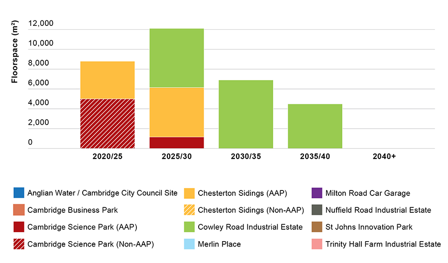
Figure 45: Indicative industrial development trajectory
8.9.4 Anticipated delivery programme
The anticipated delivery programme has been prepared based on engagement with landowners and developers, evidence base documents and a number of development assumptions. It will be informed at a later date by a Relocation Strategy, North East Cambridge Infrastructure Delivery Plan, other emerging evidence base documents and on-going engagement with stakeholders and partners. At this stage, the Councils are not advocating this programme but are inviting comment on the assumptions set out.
The table below outlines the delivery programme at North East Cambridge. The triggers for the delivery of the necessary infrastructure and community and cultural facilities will be set out in the Infrastructure Delivery Plan which is currently being prepared.
|
Development area |
2020 to 2025 |
|
Anglian Water / Cambridge City Council site |
Decommission of the Waste Water Treatment Plant 3,500m2 business floorspace completed |
|
Cambridge Business Park |
22,800m2 business floorspace completed |
|
Cambridge Science Park |
8,000m2 business floorspace completed Existing consented development completed, including Trinity Hub |
|
Chesterton Sidings |
14,500m2 business floorspace completed New industrial and storage/distribution development completed adjacent to Aggregates Railheads Completion of Station Place Open Space Shops to open with Station Approach Local Centre Existing consented development completed, including hotel and office scheme at Cambridge North Station |
|
St Johns Innovation Park |
9,300m2 business floorspace completed |
|
Trinity Hall Farm Industrial Estate |
1,500m2 business floorspace completed |
|
Nuffield Road Industrial Estate |
- |
|
Cowley Road Industrial Estate |
Existing consented development completed |
|
Merlin Place |
- |
|
Milton Rd Car Garage |
- |
|
Cambridge Regional College |
- |
|
Off-site |
Waterbeach Greenway complete (Phase 1) Chisholm Trail complete Mere Way Cycle Route complete |
|
Development area |
2025 to 2030 |
|
Anglian Water / Cambridge City Council site |
Removal of the Waste Water Treatment Plant 2,250 homes completed First shops to be completed in the District Centre (north) Green High Street Open Space (Phase 1) 4,700m2 business floorspace complete Community centre and library within District Centre opens District Centre primary school opens New Linear Park (Phase 1) Green Bridge over Milton Road at Cambridge Science Park junction |
|
Cambridge Business Park |
First shops to open within the District Centre (south) 22,800m2 business floorspace completed New Guided Busway stop complete |
|
Cambridge Science Park |
Cambridge Science Park Local Centre completed 17,500m2 business floorspace completed New last mile delivery hub completed within Local Centre 100m2 of community/cultural floorspace completed within Local Centre New access provided onto Guided Busway and Garry Drive and Science Park Brook/Open Space completed Green Bridge over Milton Road at Cambridge Science Park junction |
|
Chesterton Sidings |
Completion of Station Approach Local Centre 21,800m2 business floorspace completed Further industrial and storage/distribution development completed adjacent to Aggregates Railheads 365 homes completed 100m2 of community/cultural floorspace completed within Local Centre |
|
St Johns Innovation Park |
7,000m2 business floorspace completed |
|
Trinity Hall Farm Industrial Estate |
- |
|
Nuffield Road Industrial Estate |
- |
|
Cowley Road Industrial Estate |
6,000m2 new industrial and storage/distribution development completed |
|
Merlin Place |
- |
|
Milton Rd Car Garage |
- |
|
Cambridge Regional College |
- |
|
Off-site |
A14 underpass to Milton Country Park / Waterbeach Greenway (Phase 2) A14 noise barrier Milton Road Corridor complete Waterbeach Public Transport Corridor complete |
|
Development area |
2030 to 2035 |
|
Anglian Water / Cambridge City Council site |
Northern side of District Centre complete Green High Street Open Space (Phase 2) 2,129 homes completed 7,000m2 business floorspace completed Cultural facility within District Centre opens Cowley Road Neighbourhood Centre primary school opens New Linear Park (Phase 2) New Cowley Triangle Open Space |
|
Cambridge Business Park |
Southern side of District Centre complete 500 homes complete 22,800m2 business floorspace completed |
|
Cambridge Science Park |
16,500m2 business floorspace completed New Milton Road underpass complete |
|
Chesterton Sidings |
365 homes completed Cambridge Autonomous Metro to serve North East Cambridge |
|
St Johns Innovation Park |
9,400m2 business floorspace completed New Milton Road underpass complete |
|
Trinity Hall Farm Industrial Estate |
- |
|
Nuffield Road Industrial Estate |
275 homes completed |
|
Cowley Road Industrial Estate |
250 homes completed 6,000m2 new industrial and storage/distribution development completed |
|
Merlin Place |
- |
|
Milton Rd Car Garage |
- |
|
Cambridge Regional College |
- |
|
Off-site |
New bridge into Chesterton Fen Chesterton Fen Open Space Dualling of the A10 |
|
Development area |
2035 to 2040 |
|
Anglian Water / Cambridge City Council site |
1,122 homes completed 8,100m2 of business floorspace completed Third primary school opens Secondary school opens (if required) New Linear Park (Phase 3) |
|
Cambridge Business Park |
- |
|
Cambridge Science Park |
28,700m2 business floorspace completed |
|
Chesterton Sidings |
- |
|
St Johns Innovation Park |
9,400m2 business floorspace completed |
|
Trinity Hall Farm Industrial Estate |
- |
|
Nuffield Road Industrial Estate |
275 homes completed |
|
Cowley Road Industrial Estate |
250 homes completed 4,500m2 new industrial and storage/distribution development completed |
|
Merlin Place |
120 homes completed |
|
Milton Rd Car Garage |
100 homes completed |
|
Cambridge Regional College |
- |
|
Off-site |
- |
|
Development area |
Beyond the Plan period |
|
Anglian Water / Cambridge City Council site |
- |
|
Cambridge Business Park |
- |
|
Cambridge Science Park |
13,000m2 business floorspace completed |
|
Chesterton Sidings |
Off-site relocation and redevelopment of Aggregate Railheads 239 homes completed at former Aggregate Railheads site |
|
St Johns Innovation Park |
4,700m2 business floorspace completed |
|
Trinity Hall Farm Industrial Estate |
- |
|
Nuffield Road Industrial Estate |
110 homes completed |
|
Cowley Road Industrial Estate |
- |
|
Merlin Place |
- |
|
Milton Rd Car Garage |
- |
|
Cambridge Regional College |
- |
|
Off-site |
- |