Mitcham's Corner Development Framework SPD
4. PLANNING AND DESIGN GUIDANCE
4.1. Introduction
4.1.1. The previous chapter suggested a new movement framework, to create the public space that can to support the objectives for the Opportunity Area. This chapter sets out how buildings and new development can contribute to these objectives and realise the overall vision.
4.1.2. Specifically, this chapter of the Development Framework provides planning and design guidance on how the development principles will be used to guide future planning applications. In some cases the wording is more prescriptive, and this is reflected in the language with words such as “will” and “should”. In other cases the guidance is more discretionary and illustrative, providing a vision and aspirations for future development.
(2) 4.1.3. There are two parts to this chapter:
- Area based and general requirements for all new development within the Opportunity Area is set out within figure 44 and supplemented by general guidance on a variety of themes (refer to section 4.2).
- Site specific guidance for Henry Giles House and Staples forms the second part to this chapter and is set out within sections 4.3 and 4.4.
(1) 4.1.4. As well as complying with the planning and design guidance within this Development Framework any future planning application(s) will have to comply with the policies in the emerging Local Plan.
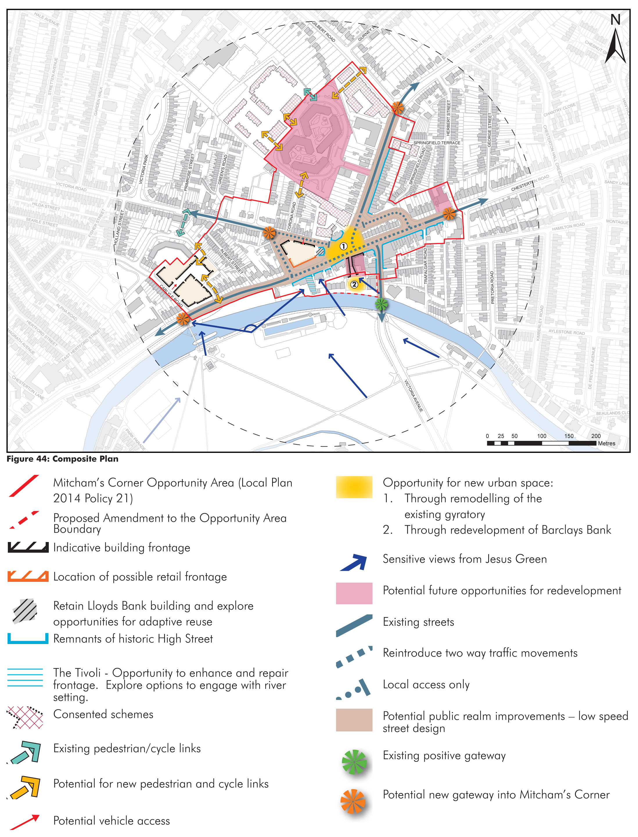
(10) Figure 44: Composite plan
4.2. Area wide guidance
(1) 4.2.1. This section, including figure 44, sets out the general requirements that will be required with all new development within the Mitcham’s Corner Opportunity Area. There are a number of sites that present potential opportunities for redevelopment (refer to Figure 44). These are not allocated within the emerging Local Plan, but if they were to come forward would be classed as windfall sites. The future redevelopment potential of these sites has been considered as part of this Development Framework, but not in the same detail as Henry Giles House and Staples.
Promoting creative and contextual design
(3) 4.2.2. Section seven of the emerging Local Plan sets out policies to protect and enhance the character of Cambridge. As such, proposals should provide a contextual approach to the design, scale and massing in response to the surrounding streets and edges of a site.
(3) 4.2.3. The guidance contained within this Development Framework should not be slavishly copied. Excellence in architecture is important - well considered, high quality architecture is promoted.
Supporting the mixed use high street
(2) 4.2.4. High streets have always been about much more than shopping. Whilst retail is an important part of the high street, people also visit for other reasons such as to visit cafes, pubs, hairdressers, doctors and dentists, banks and estate agents. They also perform an important social role too - often providing the setting where local people can come together to meet friends and participate in community activities.
(1) 4.2.5. Maintaining the vibrancy of the District Centre and reinforcing the local character and identity of the Opportunity Area as a whole, is therefore a key aspiration of Policy 21 in the emerging Local Plan.
(2) 4.2.6. Further detailed guidance on development within District Centres is set out in Policy 72 of the emerging Local Plan. Where redevelopment occurs, the following opportunities should be taken to reinforce the high street:
- Mixing complementary uses - opportunities should be taken to provide a mix of uses, including residential at upper floors. This can help to spread activity throughout the day and therefore vitality to the public realm.
- Well defined and transparent edges - for shop windows and cafes to allow activity to be visible from the street, making the public realm feel safer and more welcoming.
- ‘Spill out’ space - include opportunities for activity to ‘spill out’ into pavements such as outdoor seating. In the case of commercial buildings, this translates to externalising the more active uses.
(2) 4.2.7. It is important to note that the range of storey heights recommended within this guidance forms the starting point for the consideration of new development within the study area.
(1) 4.2.8. Applicants will be expected to produce accurate 3D computer models to inform an appropriate massing of the development on any key views and vistas. Further advice is available within appendix f of the emerging Local Plan.
4.2.9. Care should be taken over the design of roof-top plant and other equipment such as lift over-runs. These should be designed as an integral feature of the building and to be as unobtrusive as possible from surrounding streets and on any key views and vistas.
Sustainable design - overheating
(1) 4.2.10. Creating sustainable development should be a priority underpinning all new development within the Opportunity Area. Consideration should be given to the following issues:
- Health and well-being of future residents;
- Energy efficiency of new buildings;
- Design for climate change;
- Water use;
- Flood mitigation – Sustainable drainage;
- Use of materials and resources;
- Waste and recycling;
- Employment opportunities;
- Pollution
- Transport and mobility;
4.2.11. Development should comply with adopted policy related to sustainable design and construction, with reference to the most up to date guidance on sustainable design and construction.
(1) 4.2.12. As temperatures increase due to climate change, there is an increased risk of overheating in buildings. Development proposals should use architectural responses to overheating and ‘design-out’ this issue as far as practicable. Single aspect dwellings should be avoided and consideration given to the levels of glazing and orientation to ensure that new development does not overheat.
(1) 4.2.13. Future climate change as well as environmental health issues such as noise and air quality will also require early consideration as this may impact upon ventilation strategies for development proposals. Where natural ventilation is not possible, developers should prioritise low carbon approaches rather than resorting to mechanical cooling systems.
Built Form - Achieving fine grain development
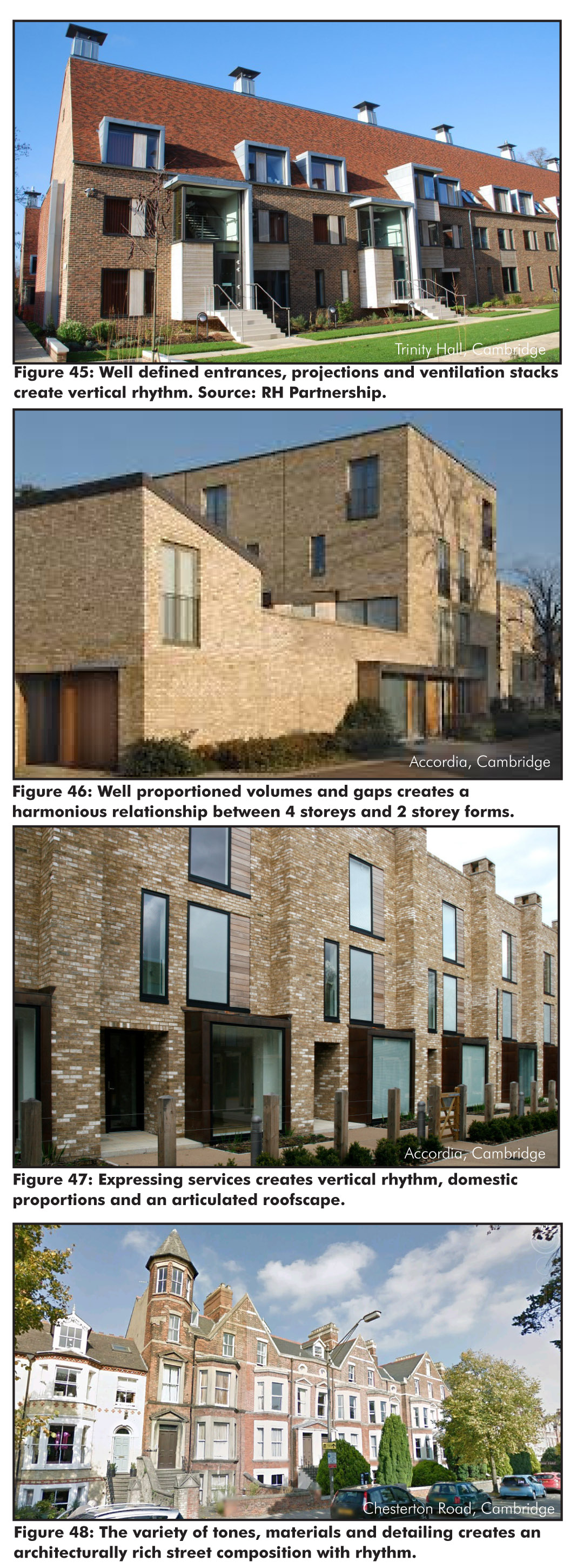
(3) 4.2.14. In the case of the Opportunity Area, architects must ensure that developments are compatible with the finer urban grain setting of the area. This can be achieved in a number of ways. Examples are illustrated in Figures 45 to 48. The ingredients of finer grain development are summarised below; architects are encouraged to think G.R.A.I.N
- Gaps and voids - breathing space between forms creates well proportioned volumes. Voids at upper floors modulate form and roofs of lower blocks offer opportunities for roof terraces and potential to increase sunlight penetration into amenity areas;
- Rhythm - vertical expression of services and function can help create human scale. Variation of heights creates rhythm. Expression of base, middle and top provides visual order and richness;
- Articulation - well proportioned projections enliven facades and add human resonance to streets. Modulation at upper floor creates articulated rooflines. Appropriate detailing and richness to elevations;
- Interactions and thresholds - Doors and windows from the street encourages activity. Well defined, layered thresholds mediate between public and private spaces, and create urban rhythm;
- Notches and Niches - Notches at upper floors can exploit views and create new glimpsed views into sites. Stepping frontages back from boundaries can create niches for spill out space.
Figures 45 to 48: Examples of built form
4.2.15. Making frontages ‘active’ adds life, vitality and interest to the public realm. To achieve this aim, development proposals will:
- Create well-designed entrances orientated on to the street to encourage activity within the public realm;
- Maximise the number of windows to increase natural surveillance; and
- Use features such balconies, winter gardens, bay windows to enliven the frontages and articulate façades.
(1) 4.2.16. Development should ensure that all residential units have access to private amenity space in the form of roof gardens, balconies and/or winter gardens. It is essential that these amenity spaces are well designed and integral to the character of the development, are located so that they are comfortable to use and are of sufficient size. It is expected that private roof gardens, balconies and winter gardens should:
- Be large enough to accommodate a table and chairs;
- Receive direct sunlight for part of the day;
- Be positioned away from or designed to mitigate sources of noise and poor air quality.
(4) 4.2.17. When considering the appropriate car parking solutions on site, applicants should consider a variety of car parking solutions to achieve a balance between functionality and placemaking. On tighter sites, podium parking solutions may be appropriate as well as incorporating dwelling typologies that integrate the parked car for example flats over garages (FOGs) to create mews style streets and spaces. Any car park access will need to be well resolved to reduce the possibility of it negatively impacting on the quality and character of the street.
(4) 4.2.18. Given the proximity of the area to the City Centre, low car ownership or even car free development may be considered appropriate, especially when supplemented through the provision of Car Clubs.
Drainage and surface water flood risk
(1) 4.2.19. Developers must pay close attention to drainage and surface water flood risk issues. Architects are encouraged to employ water sensitive urban design to the process of integrating water cycle management within their schemes. Refer to figures 49-51. Policies 31 and 32 in the emerging Local Plan provide detailed guidance on integrated water management and flood risk.
(3) 4.2.20. Applicants should refer to the Cambridge City Council Cycle Parking Guide for New Residential Developments (February 2010). Cycle parking should be secure, well integrated and convenient to use and make provision for ‘off gauge’ or non-standard bicycles and trailers. Cycle parking for businesses should be as close to the main entrance as possible.
(4) 4.2.21. There will be many opportunities for enhancing the local biodiversity through development. Initiatives that could be considered are:
- Tree and other planting where appropriate;
- Water resources in association with SUDs and other landscape features;
- Nesting opportunities for a variety of bird and bat species. Habitats for insects;
- Brown or green roofs(refer to appendix J of the emerging Local Plan for further detail).
Figures 49 to 51: Sustainable drainage
Recycling and waste facilities
4.2.22. It is expected that any development which comes forward on the site will successfully integrate refuse and recycling facilities and clearly separate commercial and residential waste streams.
(2) 4.2.23. Public art is encouraged as part of development proposals in accordance with emerging Local Plan Policy 56. The engagement of an artist should be undertaken at an early stage of the design process to ensure that it is well integrated into proposals.
4.2.24. The development of sites within the Opportunity Area is likely to result in increased demands for community infrastructure such as public open space, sports health and community facilities. Some of these demands may be met on site but others will be secured through commuted sums to provide new or enhanced infrastructure off site. Planning Obligations via a Section 106 agreement will be needed to deliver this infrastructure. The full list and scope of these Planning Obligations will be defined through the consideration of the planning application(s) for the site(s).
(1) 4.2.25. The delivery of the new street layout and large areas of new public realm is complex and requires significant funding. It is likely that funding will need to be found from more than one source which, for example, could include (amongst others) future tranches of the Greater Cambridge City Deal, site specific section 106 agreements (planning obligations), Community Infrastructure Levy (CIL) payments, or special capital project budgets held by either the City or County Councils or other authorities.
4.3. Site guidance - Henry Giles House
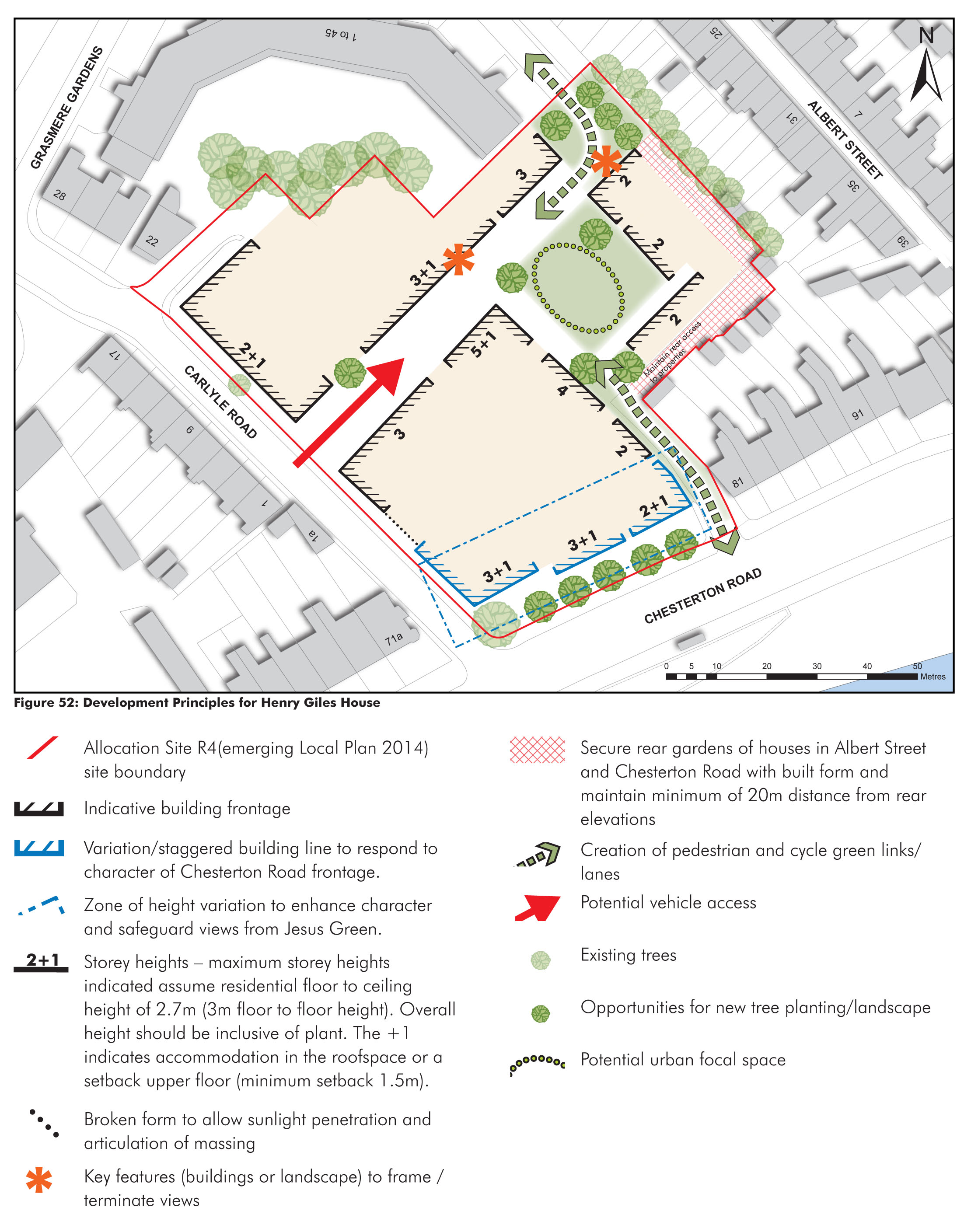
(1) 4.3.1. The site is located on the corner of Chesterton Road and Carlyle Road and is approximately 0.6 miles from the City Centre.
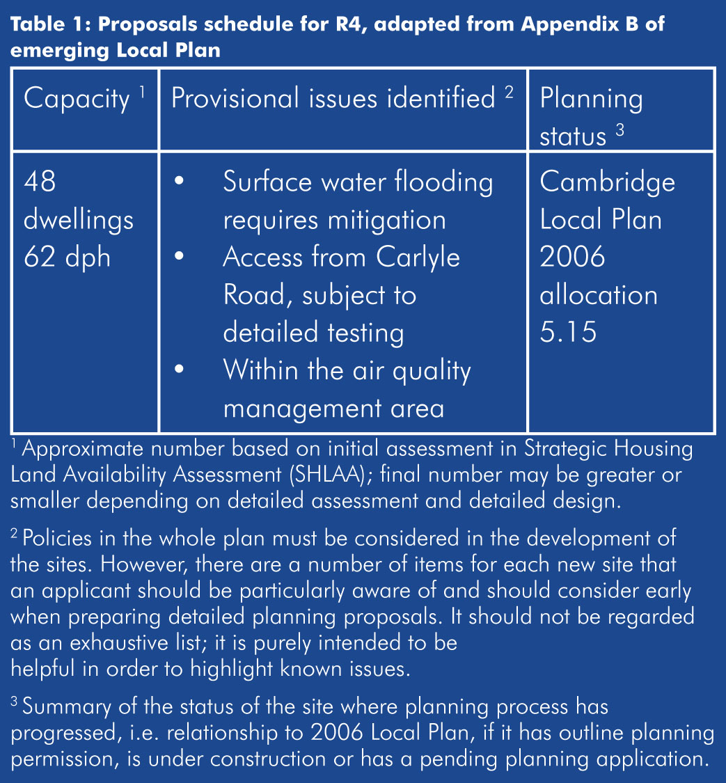
4.3.3. Allocated site (R4) within the emerging Local Plan for housing. Site falls within Castle and Victoria Conservation Area.
Table 1
4.3.5. Offices (B1) and parking.
4.3.6. Key development principles are summarised in Figure 52. These will need to be considered when developing proposals for the site. In addition, further principles are established below.
(10) Figure 52: Development principles for Henry Giles House
Responding to a variety of edge conditions
(2) 4.3.7. There are a number of varied edges to the site, each with a different character, which development is expected to respond to.
- Southern Edge / Chesterton road frontage - Building heights along the Chesterton Road frontage east and west of the site vary between 2-3.5 storeys creating stepped rooflines. Staggered building lines to the east of the site, reveal gables and create a character of well expressed vertical roofline elements. Buildings to the West of the site, are architecturally rich in detail both in terms of elevations and roofscape. Gable frontages feature and bay windows are common place.
- Western Edge / Carlyle Road frontage - The scale of the street is more intimate and uniform in comparison to Chesterton Road. Terraces immediately adjacent to the west of the site are of 2.5 storeys (+ basement). The repeating forms, creates façades and rooflines that are well articulated with bay windows and chimneys. The topography of the street rises towards Alexandra Gardens.
- Northern edge - bounded predominantly by the Protected Open Space of Grasmere Gardens, a 3 storey late 1970s housing scheme.
- Eastern edges -bounded mainly by the rear garden fences/walls of residential terraces of Chesterton Road and Albert Street. Vehicle access to the rear of 81-91 Chesterton Road currently exists. The status of this access is unknown.
(3) 4.3.8. An urban design led approach should be adopted to inform the appropriate scale and massing of redevelopment proposals for the site. This should result in a well-designed scheme that fits into its context, helps to define key entrances and routes and responds to key views and vistas including views into and out of the site into the Conservation Area.
4.3.9. Building heights shown in Figure 57 are expressed as storey heights. Residential floors are assumed to have 2.7m floor to ceiling height (3m floor to floor height). Floor to floor heights assumes a 300-400mm construction depth for floors.
4.3.10. There will be some differences in floor to ceiling heights between buildings. These small changes are acceptable and indeed help to create greater variation in roofscape and overall massing.
4.3.11. Building heights shown are intended to promote development that responds to the sites key contextual factors and placemaking opportunities. There maybe the opportunity for an increase in height (5+1 storeys) to occur within the site , subject to an acceptable design. Building heights should be stepped down around the eastern edges to respond to existing properties. Along the Chesterton Road frontage the heights expressed are intended to reflect the prevailing character and respond to sensitive views from Jesus Green the character of the Castle and Victoria Conservation Area. Building heights along the north western edge of the site should reflect those of the adjacent terrace of 1-17 Carlyle Road.
4.3.12. Proposals will be expected to incorporate architectural modulation and variety to generate a varied roofscape and streetscape. Contemporary forms of massing should be considered along more traditional forms. Innovative use of roofscape for accommodation and the use of setback upper floors can be an effective way of moderating the overall scale and massing of the redeveloped site whilst creating well-articulated forms.
(1) 4.3.13. Applicants will be expected to produce accurate 3D computer models to inform an appropriate massing of the development on any key views and vistas. Refer to appendix F of the emerging plan for further advice.
A series of individual buildings
(1) 4.3.14. Key to creating an appropriate scale and massing for the site is the principle of creating a series of individual buildings. Staggering the approach to massing both in plan and in height will help development achieve a diversity of scale that is appropriate to the sites variety of edges, create a finer grain of development and make for a more interesting streetscape.
4.3.15. Blocks should be expressed as individual buildings, with individual entrances and doors. Arrangements which create vertical circulation (rather than horizontal corridors) are encouraged.
4.3.16. Further guidance relating to finer grain development can be found on page 45.
(1) 4.3.17. Henry Giles House is very prominent from views across Jesus Green a Protected Open Space that lies within the Historic Core of the Central Conservation Area. This is a sensitive location and therefore the form of developments and positioning of buildings form should respond to these views. Creating a finer grain of development along Chesterton Road will be critical to this.
(1) 4.3.18. The development principles summarised in figure 57 are intended to generate a variety of building heights across the site and achieve a varied skyline and roofscape, as this is an important feature of the existing streetscape along Chesterton Road.
4.3.19. Existing vehicle access is from Carlyle Road will be subject to detailed testing. Details will need to be agreed with Cambridgeshire County Council as highway authority.
Reconnecting streets and spaces
(2) 4.3.20. Development should reconnect where feasible with existing streets and spaces. Any new development should provide links from Chesterton Road into the site and reconnect through to Grasmere Gardens. These new linkages should provide through access for cycles and pedestrians only and could posses a more intimate green ‘lane’ character, where space is shared.
4.3.21. The status of the existing access to the rear of Chesterton Road will need to be established and may need to be incorporated into redevelopment proposals.
Integrated water management - a dynamic new focal space
(1) 4.3.22. Surface water flooding requires mitigation on the site. Smaller, more resilient features distributed throughout the development should be used, instead of one large management feature. Figure 49 provides examples of how to successfully integrate SuDs into developments.
4.3.23. There is an opportunity to create dynamic focal space within the site that deals with water.
4.3.24. Above ground multi-functional storage would be the first choice, together with a combination of sustainable drainage source control features such as rain gardens, permeable paving, swales, rills and green/brown roofs.
4.3.25. When the site is redeveloped, it will be expected that attenuation will be required on site and given the proximity to the River Cam, such measures will be required to safeguard or improve the water quality leaving the site.
4.3.26. The redevelopment of site should improve the quality of the public realm adjacent to the site boundaries. The opportunity to make streetscape improvements at the new access into the site along Carlyle Road should be explored. A consistent material such as blockwork, across the entrance and the road perhaps with a raised table, could be used to break down the linearity of the highway and reinforce low vehicle speeds.
4.3.27. The existing Silver Birch tree along Carlyle Road should be retained subject to feasibility and condition assessment.
(1) 4.3.28. Street trees should be introduced along Chesterton Road frontage as part of any public realm improvements.
4.4. Site guidance - Staples
4.4.1. The site is located on the corner of and is approximately 0.38 miles from the City Centre.
4.4.2. 0.38ha (site boundary as shown on Figure 53).
4.4.3. The site is not allocated within the emerging Local Plan. However, the site falls within the Castle and Victoria Conservation Area and also occupies a very prominent location within the Opportunity Area. The site, therefore presents considerable future redevelopment potential that could contribute to the vision and objectives of the Development Framework. As such, it is considered appropriate to provide further detailed guidance for this site.
4.4.4. The site is occupied by two retail uses (Staples and Evans Cycles) with associated car parking provided above. A third retail unit located next to the existing Lloyds Bank has been let and is expected to be open September 2016. A fourth unit is currently being fitted out above Evans Cycles and is currently being marketed for a variety of uses including offices, gym and educational. The first floor of the existing Lloyds Bank is currently being converted into two flats.
(1) 4.4.5. Key development principles are summarised in Figure 53. These will need to be considered when developing proposals for the site. In addition, further principles are established below.
Figure 53: Development principles
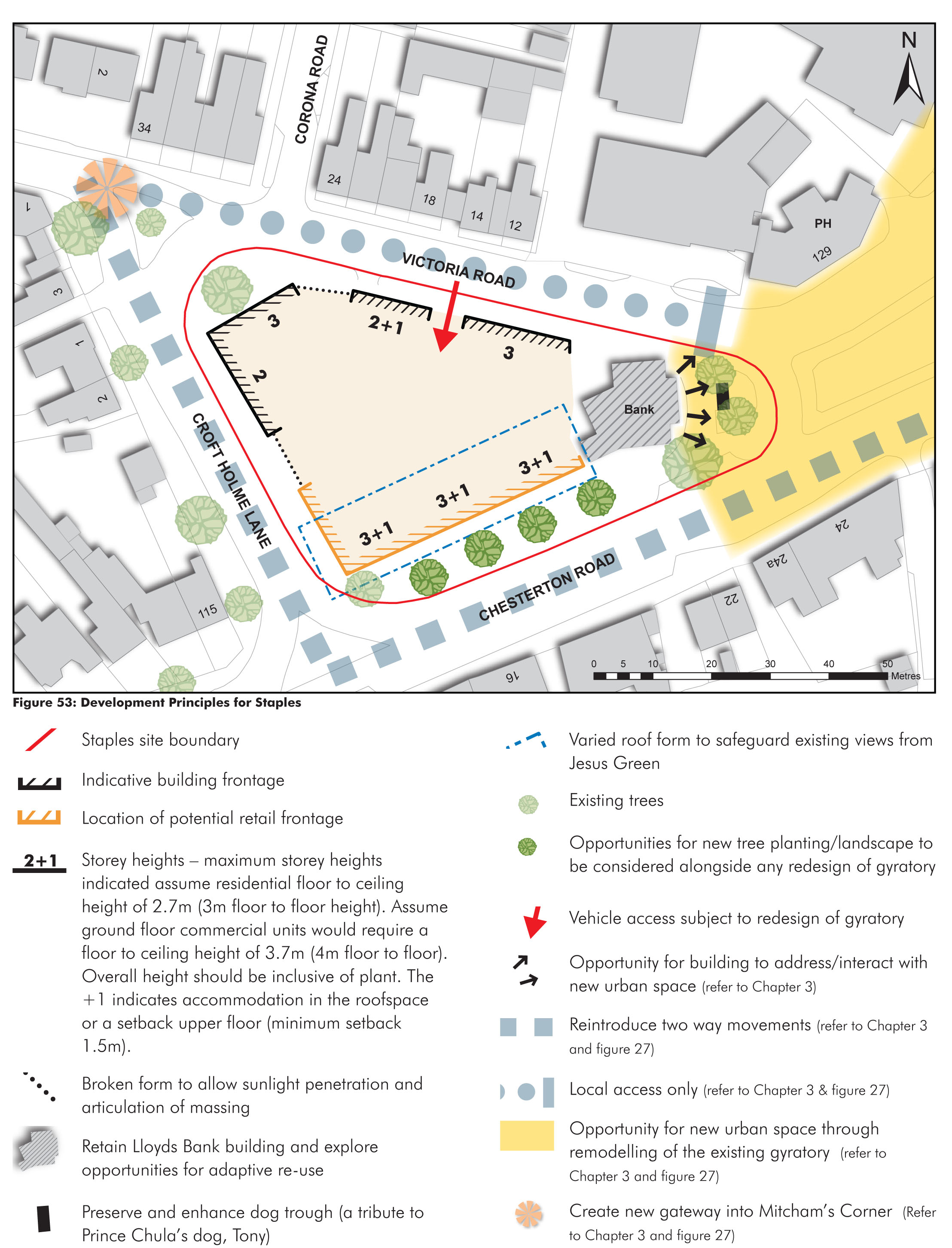
4.4.6. The change in road layout and street design promoted within chapter 3 could help to unlock the redevelopment potential of the existing Staples site.
4.4.7. It is therefore essential that development proposals for the site should respond to any future options for the remodelling of the gyratory. This could include: exploring a new retail built frontage along Chesterton Road to help reduce the street width of Victoria Road; considering the form of development at the north western corner of the site to help create a new gateway into Mitcham’s Corner; and exploring adaptive reuse opportunities for the existing Lloyds Bank building which address/interact with the potential new public space that is promoted within Chapter 3.
Responding to a variety of edge conditions
4.4.8. There are a number of varied edges to the site, each with a different character, which development is expected to respond to.
- Southern Edge / Chesterton Road frontage - This edge fronts the principal street of Chesterton Road and forms the start of the high street when approaching from the West. Heights adjacent to this frontage and east of the site vary between 2-3.5 storey. Building lines feel more continuous; terraces to the east and adjacent to the site contribute to this. The 2 storey Lloyds Bank occupies the eastern apex of the southern frontage. Chimneys punctuate rooflines, frequent and more orderly arrangement of windows/entrances create vertical rhythm. Retail units create a clearly expressed ground floor.
- Western Edge / Croft Holme Lane - The scale of the street is more intimate in comparison to Chesterton Road with building heights predominately 2 storeys. Shallow landscaped set backs contribute to this. The topography of the street rises towards Victoria Road. Gaps between forms created by rear gardens and access points, are more evident.
- Northern edge / Victoria Road - Terraces immediately adjacent to the north of the site are between 2-2.5 storeys (+ basement). The combination of a subtle staggering of building lines, street topography and chimneys creates a varied and interesting roofscape. Facades are well ordered with projecting bay windows at ground floor. Set backs are clearly defined, with low brick walls and railings.
(3) 4.4.9. An urban design led approach should be adopted to inform the appropriate scale and massing of redevelopment proposals for the site. This should result in a well-designed scheme that fits into its context, helps to define key entrances and routes and responds to key views and vistas including views into and out of the site into the Conservation Area.
4.4.10. Building heights shown in Figure 53 are expressed as storey heights. It assumes that where commercial ground floor uses are proposed, the floor to ceiling height will typically be around 3.7m (floor to floor height 4m). Residential floors are assumed to have 2.7m floor to ceiling height (3m floor to floor height). Floor to floor heights assumes a 300-400mm construction depth for floors.
4.4.11. There will be some differences in floor to ceiling heights between buildings. These small changes are acceptable and indeed help to create greater variation in roofscape and overall massing.
4.4.12. Building heights shown (figure 53) are intended to promote development that responds to the sites key contextual factors and placemaking opportunities. Along Chesterton Road, the heights expressed (3+1 storeys) are intended to reinforce the character of the district centre, and respond to the principal nature of the street which it fronts onto. Heights along this frontage are also intended to reduce the visual impact on longer distance sensitive views across Jesus Green. Building heights should step down along the northern edges to respond to adjacent existing properties. A reduction in scale and a more broken form of development is promoted along Croft Holme Lane to not only respond to the character of this street, but to also provide greater opportunities for daylight into the site.
4.4.13. Proposals will be expected to incorporate architectural modulation and variety to generate a varied roofscape and streetscape. Innovative use of roofscape for accommodation and the use of setback upper floors and stacks. The use of set back upper floors and stacks will allow for a scale of development more suited to the finer grain character of the surrounding area whilst epitomising the land available.
4.4.14. Applicants will be expected to produce accurate 3D computer models to inform an appropriate massing of the development on any key views and vistas. Refer to appendix F of the emerging Local Plan for further advice.
A series of individual buildings
(1) 4.4.15. Key to creating an appropriate scale and massing for the site is the principle of creating a series of individual buildings. Staggering the approach to massing both in plan and in height will help development achieve a diversity of scale that is appropriate to the sites varied context, create a finer grain of development and make for a more interesting streetscape. Blocks should be expressed as individual buildings, with individual entrances and doors. Arrangements which create vertical circulation (rather than horizontal corridors) are encouraged.
4.4.16. Further guidance relating to finer grain development can be found on pages 45.
Retention and adaptation of Lloyds Bank
4.4.17. The key development principles promotes the retention and adaptation of the existing Lloyds Bank as part of any redevelopment proposals for the site.
4.4.18. The bank, despite its alteration over the years, is considered to have a certain style which is appropriate to the local area and it has a visual relationship with the Portland Arms (which is a Building of Local Interest) over the road, built of similar materials.
4.4.19. The potential re-use and adaptation of the existing bank should be considered in the context of any new urban space that could be created as part of the remodelling of the existing gyratory system. (Refer to chapter 3)
4.4.20. Any commercial use should be located on Chesterton Road frontage and the eastern corner, to support the function and future vitality of the ‘high street’. It is envisaged that servicing for retail uses will be from the street.
4.4.21. Existing vehicle access is from Chesterton Road. Details will need to be agreed with Cambridgeshire County Council as highway authority.
4.4.22. Surface water flooding requires mitigation on the site. Smaller, more resilient features distributed throughout the development should be used, instead of one large management feature. Figure 49 provides examples of how to successfully integrate SuDs into developments.
4.4.23. Above ground multi-functional storage would be the first choice, together with a combination sustainable drainage source control features such as rain gardens, permeable paving, swales, rills and green/brown roofs.
4.4.24. When the site is redeveloped, it will be expected that significant below ground attenuation will be required on site and given the proximity to the River Cam, such measures will be required to safeguard or improve the water quality leaving the site.
(2) 4.4.25. The redevelopment of the site should improve the quality of the public realm adjacent to the site boundaries.
4.4.26. The existing Lime tree adjacent to Lloyds Bank should be retained subject to a condition assessment.
4.4.27. Street trees should be introduced where possible, and in particular along Chesterton Road frontage as part of any public realm improvements. The presence of underground services within this area requires careful consideration.
4.4.28. The provision of trees improves air quality, reduces dust, muffles noise and offers shade and shelter. It also reduces the heat island effect.